• Hello, please take a minute to check out our awesome content, contributed by the wonderful members of our community. We hope you'll add your own thoughts and opinions by making a free account!

Pattern Marvelous March

888287fb1021e1a064859ddddde60b7f.jpg


Sent from my iPhone using Tapatalk
 
Need euro to have a stronger high pressure to the north. It has it at 1036 mb need to be more like 1040mb.
 
At least we all get cold after this. The COLD will be board hopefully just in time to end winter.
Need something to kill these mosquitoes. Hasn’t been cold enough this year. Maybe all this rain will have washed away some of their breeding nest. (Stagnant Water)
 
Most folks are not going to like the EPS for the crucial period 3/3-4 as it like the operational is warmer with a further NW storm track. :(
 
Most folks will like that once it does finally get cold on the EPS, it stays for awhile/winter will be back in control til 3/10.
 
Really not surprising to see the NW trend in light of how much weaker the SE Canada vortex has become in later runs of the Euro and the GFS.

Oth, worth mentioning the Indian Ocean is lighting up w/ convection as a Kelvin Wave passes over, it's really just a matter of time now before our pattern snaps into spring &/or early summer. By the time this convection becomes centered over Indonesia and the rest of the Maritime Continent, we usually turn blowtorch warm, which for late March standards in a warming world can be borderline summer-like.

Screen Shot 2019-02-26 at 3.28.44 AM.png
 
Really not surprising to see the NW trend in light of how much weaker the SE Canada vortex has become in later runs of the Euro and the GFS.

Oth, worth mentioning the Indian Ocean is lighting up w/ convection as a Kelvin Wave passes over, it's really just a matter of time now before our pattern snaps into spring &/or early summer. By the time this convection becomes centered over Indonesia and the rest of the Maritime Continent, we usually turn blowtorch warm, which for late March standards in a warming world can be borderline summer-like.

View attachment 16623

Sounds nice, no more dry cold or cold during trashy snow climo later March
 
I actually have a question myself, even tho the SE Canada lobe was not good this run of the gfs, this strong trough on the GLs is another way to actually help us out as long as the SW is timed nicely right ?, (6z gfs)
95FBE544-0C86-423B-AAC1-AA2CE0848C50.gif
 
Profiles support a simple rain/snow
split based on sfc temp early Sunday, but for the second wave a
mixed bag of p-types results given the gradient of thicknesses
across the area. Once again, PoPs are still very low overall,
reflecting our low confidence, but we feel it is worth mentioning
in the fcst.
GSP does mention the possibility in their long range forecast...
 
06z GEFS looks like we increased snow means a lot in NC .. NC still in the best position here ... most of the gefs see at least two systems hitting one being a big hitter the other being moderate scattered snow showers after
 
Please stop whining and calling fail when we are still a week out and NC still has a chance. especially when you already made your mind up yesterday that you were not going to get anything from this storm because you are too far south. Just because you were never really in the game to begin with doesn't mean you have to come on here and crap on other folks who have a chance because the overnight runs were not as good. You already made your mind up that it's not happening for you, so why keep following the storm? It's the same two or three posters with the same snarky comments all the time.
 
Please stop whining and calling fail when we are still a week out and NC still has a chance. especially when you already made your mind up yesterday that you were not going to get anything from this storm because you are too far south. Just because you were never really in the game to begin with doesn't mean you have to come on here and crap on other folks who have a chance because the overnight runs were not as good. You already made your mind up that it's not happening for you, so why keep following the storm? It's the same two or three posters with the same snarky comments all the time.
EXACTLY that’s what I’m trying to say .. if ur out of the game and wanna complain gooooooo to banter ?
 
If the first “event” can lay the snow cover down for western NC northward it could open a small window for the second “event” to undercut further south under snow cover and possibly bring some light snow from north Georgia up through Charlotte NC. However, a more likely scenario favors Kentucky to DC which would place North Carolina in a favored position for the second event. No changes from me...summer will hit in a hurry for late March. CAD will repear some with cool air/rain after June 1st. Snow totals for March could exceed 6” for the NC mountains with less than 6” totals near Raleigh to Wilkesboro. Northern areas will be favored over southern areas in a pattern like this (Winston > Asheville). No significant ice will exist in this new snowy pattern with cold rain being the other precipitation type.
 
We're just gonna ignore this?
gfs_mslp_pcpn_frzn_us_32.png

gfs_mslp_pcpn_frzn_us_33.png

snku_acc.us_ma.png
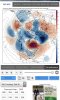
Yes a lot of GEFS members this morning also had this secondary piece .. some show it as the Gfs operational did and some show just a bigger storm in general.. this would be interesting either way because we have colder temps do ratios would be high
 
Come on baby let’s get some mid March action with this look ... -NAO finally ?
 

Attachments

  • 5633E248-8A6A-48D5-B2A7-EED815D2F24A.jpeg
    5633E248-8A6A-48D5-B2A7-EED815D2F24A.jpeg
    769.1 KB · Views: 48
  • Like
Reactions: ajr
GAWx Thanks for all your midnight tracking past week. Really enjoy your post and its so quick n easy to wake up, log in and get overnight update in 20 seconds without having to go dig on model sites.

One thing we've wised up to , is to never trust models until inside 120 hr mark this winter. I'd be cautious even with this second wave/opportunity for middle next week. Euro past few years is notorious for showing the goods day 6-7 and come day 5, pulling the rug out. Just happened again with yesterday 12z run and look what happened last night 0z. However it was no surprise to anyone/self.
 
We went from a storm looking extremely suppressed on the 3-4th to now a MA/NC storm, incredible

No blocking. what is keeping this suppressed besides the ridging and confluence and general s/w evolution? Nothing... this was my concern from the get go, we really need the cold and high to not trend the other direction. This is why I mentioned I wrote off March 1-5 (even though the models actually differ on the second wave and make it March 5), the second wave on March 5-6 looks much better to me and has the most potential for N.C. at least. But I think the first wave has the most potential for the SE as a whole so I see why people aren’t necessarily excited for wave 2. I just feel like we are lacking the substantial deep cold needed for wave 1 to work...but there’s still time for models to change so I wouldn’t give up yet..


Sent from my iPhone using Tapatalk
 
Last edited:
I don't think its all that crazy to say the euro could come back south at 12z. Unless I'm horribly mistaken, that's what it did from 0z to 12z yesterday
 
Back
Top