-
Hello, please take a minute to check out our awesome content, contributed by the wonderful members of our community. We hope you'll add your own thoughts and opinions by making a free account!
You are using an out of date browser. It may not display this or other websites correctly.
You should upgrade or use an alternative browser.
You should upgrade or use an alternative browser.
Wintry Dec 8-10th Winter Storm
- Thread starter SimeonNC
- Start date
BlueRidgeFolklore
Member
Is Charleston considered the Midlands ? That's where you are correct ?
Charleston is the low country. Midlands is central SC.
Kylo
Member
For central NC we need to cash in as much in the initial overrunning, once SLP moves to atlantic we are screwed.
Storm5
Member
The Huntsville AFD from early am was far more excited than I thought it would be https://forecast.weather.gov/product.php?site=NWS&product=AFD&issuedby=HUN&glossary=1
Sent from my iPhone using Tapatalk
Sent from my iPhone using Tapatalk
BlueRidgeFolklore
Member
“Euro is the outlier”
-CJ
I'm telling you man, that 2014 debacle has him rattled for making bold predictions like the Euro is showing. He'll make bold predictions about the mountains but not the Upstate. Can't blame him really.
WeatherAddiction
Member
Any one have the most recent EPS members?
ECMWF sleet, ZR, and snow (with at least some of the sleet removed)...but you know how I feel about the sleet forecast ")


Kylo
Member
Come out in about 45 mins.Any one have the most recent EPS members?
RollTide18
Member
The backside rain gets us heavy. The 850 line just stays in Chatham county the whole time...pain.
Verbatim it's 33F rain
View attachment 8488
View attachment 8487
850s below freezing across all of Alabama but no snow, why?
B
Brick Tamland
Guest
All the models showing a high impact event for most of NC, Raleigh and to the west. Still have three days to go, though.
bud006
Member
Never underestimate the wedge in NE GA. I don't see the city of ATL getting much of anything but as always Gwinnett, Forsyth, etc tend to hold on to the cold air longer.
Living in NE Forsyth County, I’ve seen the wedge stay entrenched more than the models depict on several occasions .Feb. 2015, (I think it was 15), our cold rain turned to 0.4 ZR and knocked out our power.
I’m very interested to see the DP and the upper-air temps as the precip starts. Just my amateur two cents.
—30—
Sent from my iPhone using Tapatalk
Kylo
Member
Guessing the precip its showing is very light.850s below freezing across all of Alabama but no snow, why?
The surface map is not translating to the snowfall accumulation map on the Euro. Its showing rain on the surface map but the backside gives me an additional 3" of frozen precip. Not sure what's going on between the two.For central NC we need to cash in as much in the initial overrunning, once SLP moves to atlantic we are screwed.
 The best example of 85 and N, I have ever seen on a model output!
B
Brick Tamland
Guest
Living in NE Forsyth County, I’ve seen the wedge stay entrenched more than the models depict on several occasions .Feb. 2015, (I think it was 15), our cold rain turned to 0.4 ZR and knocked out our power.
I’m very interested to see the DP and the upper-air temps as the precip starts. Just my amateur two cents.
—30—
Sent from my iPhone using Tapatalk
I remember the ice storm here around this same time in December 2002. We were just supposed to have cold rain that night.
North and West of I-85 in NC for sure will have a high impact event.All the models showing a high impact event for most of NC, Raleigh and to the west. Still have three days to go, though.
DadOfJax
Member
Anybody?Any thoughts on Gatlinburg for those people who understand the geography and its effects in these situations?
NBAcentel
Member
Just got a appetizer here in salisbury, got a very quick gusty burst of snow,
B
Brick Tamland
Guest
The only question here appears to be what will the temps be during the event. I think the CAD could end up being stronger than modeled here, which would give us more frozen precip. I don't think it will be all snow, but will mix at times with sleet and freezing rain, but I could see it end up being more frozen precip than rain. A degree or two can make all the difference, as well as where exactly you are located when it comes to Wake County.
snowlover91
Member
I like this run of the Euro, great classic 850 low track from Dallas to central Mississippi to just south of Wilmington. I expect things will trend a bit colder if that holds. A lot of complex things to figure out in regards to phasing and the backside snow on this system. The initial front end snow looks legit and quite heavy.
Lots of rain. They are on the wrong side of the mountains.Any thoughts on Gatlinburg for those people who understand the geography and its effects in these situations?
NBAcentel
Member
Is anyone else having server issues again?
snowlover91
Member
I'm seeing a few RGEM members now with a 1042-1043 HP, strongest I've seen from any model.

Sandstorm94
Member
I'm seeing a few RGEM members now with a 1042-1043 HP, strongest I've seen from any model.
1043? Let's go!
Storm5
Member
I turned the live thread off while we work on some issues . Thanks
wannabwm
Member
Yes it does seem to be lagging
Is anyone else having server issues again?
RollTide18
Member
Guessing the precip its showing is very light.
I guess because this map shows snow down into @deltadog03 neck of the woods
Storm5
Member
That’s not snow .... well in the upper levels it might be but it’s very light rain at the surface
Nomanslandva
Member
There is a good phone screenshot above that makes it look not so good if you want lots of snow. Wrong side of the big mountains. But that's one run of one model.Anybody?
NBAcentel
Member
The reason why it's showing rain in some of those areas in al with the ull is probably Becuase the snow growth region is not supportive of developing snow flakes
snowlover91
Member
Didn't see it mentioned but the NAVGEM adjusted south and also has the finger of precip faster than any other model I've seen.

B
Brick Tamland
Guest
Wow, 156 users on now. Those 67 guests need to sign up, too. Word must be getting out how big of a storm this could possibly be.
Too bad the Panthers are not at home this weekend. That would be fun to watch!
B
Brick Tamland
Guest
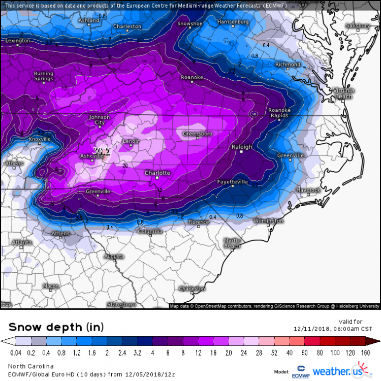
And another pretty map to look at.
NBAcentel
Member
Actually it is.Wow, 156 users on now. Those 67 guests need to sign up, too. Word must be getting out how big of a storm this could possibly be.
Round Oak Weather
Member
Has the eps came out?
Kylo
Member
12z EPS
5” mean to 95.

5” mean to 95.
Control is pretty lit too, albeit a lot of this S/E of the mountains is mixed precip
.png")
Kylo
Member
Members

