Wow! This is easily the worst thunderstorm I’ve experienced in many months. Lead by very strong winds, torrential rains with CTG lightning followed quickly. I was trying to get home to beat the storm but too many others had the same idea and thus the traffic was so heavy it delayed me. Fortunately I got home safely but there’s no power. Waiting it out in the car til the rain slackens, which it’s starting to do.
BULLETIN - IMMEDIATE BROADCAST REQUESTED
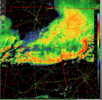
SEVERE THUNDERSTORM WARNING
NATIONAL WEATHER SERVICE CHARLESTON SC
337 PM EDT THU MAY 9 2024
THE NATIONAL WEATHER SERVICE IN CHARLESTON HAS ISSUED A
* SEVERE THUNDERSTORM WARNING FOR PORTIONS OF...
BRYAN COUNTY IN SOUTHEASTERN GEORGIA...
CHATHAM COUNTY IN SOUTHEASTERN GEORGIA...
* UNTIL 430 PM EDT.
* AT 337 PM EDT, SEVERE THUNDERSTORMS WERE LOCATED ALONG A LINE
EXTENDING FROM NEAR HUTCHINSON ISLAND TO BELFAST, MOVING SOUTHEAST
AT 45 MPH.
HAZARD...60 MPH WIND GUSTS.
SOURCE...RADAR INDICATED.
IMPACT...EXPECT DAMAGE TO TREES AND POWERLINES.
* LOCATIONS IMPACTED INCLUDE:
TYBEE ISLAND, WILMINGTON ISLAND, FORT PULASKI NATIONAL MONUMENT,
MIDTOWN SAVANNAH, DOWNTOWN SAVANNAH, COFFEE BLUFF, HUNTER ARMY
AIRFIELD, MONTGOMERY, THUNDERBOLT, VERNONBURG, FORT MCALLISTER,
SANDFLY, SAVANNAH HISTORIC DISTRICT, WINDSOR FOREST, AND ISLE OF
HOPE.
*Edit: Power finally came back after 4 hour outage!

Measured a much appreciated ~0.8”.