Built to withstand the harsh elements of the area, not for opulence in easy living places.That is just plain ugly, those houses, WTF>?
-
Hello, please take a minute to check out our awesome content, contributed by the wonderful members of our community. We hope you'll add your own thoughts and opinions by making a free account!
You are using an out of date browser. It may not display this or other websites correctly.
You should upgrade or use an alternative browser.
You should upgrade or use an alternative browser.
Wintry Winter Discussion 2023/24
- Thread starter Rain Cold
- Start date
I’ve been up there when I was in the army. They’re ugly as hell, but they have the best damn insulation during that long bitterly cold night that is winter up there.That is just plain ugly, those houses, WTF>?
The JMA Seasonal has a product to forecast daily for the next few months. Not a bad look if you ask me. There's probably little accuracy, but I'll post it here.
November:
December:
January:
November:
December:
January:
The JMA Seasonal has a product to forecast daily for the next few months. Not a bad look if you ask me. There's probably little accuracy, but I'll post it here.
November:
December:
January:
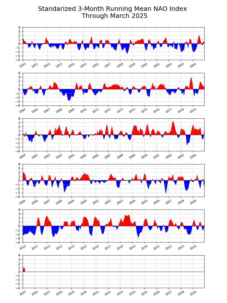
Interesting…. That does follow along fairly closely with 2009-2010 which is one of the big analogs for this year.
severestorm
Member
Temperature profiles don't match to that year thus far.Interesting…. That does follow along fairly closely with 2009-2010 which is one of the big analogs for this year.
severestorm
Member
Temperature profiles don't match to that year thus far.

NCSNOW
Member
- Joined
- Dec 2, 2016
- Messages
- 9,203
- Reaction score
- 18,075
Super El Nino is still the rumor mill / hype I'm hearing.
09-10 was a perfect placed / location El Niño. Don't believe it was considered what we term a super el Niño year. I could be wrong. I do know it was positioned just right out there in the pacific to where we where not just firehosed with pacific origin air. Always the fear when you get high end el Niño .
09-10 was a perfect placed / location El Niño. Don't believe it was considered what we term a super el Niño year. I could be wrong. I do know it was positioned just right out there in the pacific to where we where not just firehosed with pacific origin air. Always the fear when you get high end el Niño .
severestorm
Member
The reason those years were amazing was because of the NAO. We haven't had solid NAO support since then. I remember going out in summer with my jacket because of the deep trough.Super El Nino is still the rumor mill / hype I'm hearing.
09-10 was a perfect placed / location El Niño. Don't believe it was considered what we term a super el Niño year. I could be wrong. I do know it was positioned just right out there in the pacific to where we where not just firehosed with pacific origin air. Always the fear when you get high end el Niño .
The CANSIP Seasonal is coming in hot! Fairly canonical El Nino pattern after New Year's..gif")
.gif")

LovingGulfLows
Member
- Joined
- Jan 5, 2017
- Messages
- 1,291
- Reaction score
- 3,251
The CANSIP Seasonal is coming in hot! Fairly canonical El Nino pattern after New Year's.View attachment 135960
View attachment 135959View attachment 135961
Look at that warmer than avg air in Canada. That would imply quite a bit of blocking near the arctic and bouts of arctic air being sent down south into the CONUS in the new year. Large parts of the South are well overdue for a memorable snow event...maybe this will be the winter....can't be worse than last winter which was among the worst of the last 50 years. I'm just looking forward to a regime change that El Nino will provide after three years of La Nina.
Itryatgolf
Member
Like I've alluded to, the key will be the base of the niño. Central based is ideal. Also if we can manage a -nao at some point this coming winter.
iGRXY
Member
Well we have shown to actually get a -NAO these past couple of winters so hopefully that trend continues. Looks like we could finally have some Pacific support with an active subtropical jet. But as always it almost 100% comes down to one thing and one thing only and that's timing.
Wash rinse repeat

Avalanche
Member
Curious if Gulf and Atlantic water temps recede back to normal as we approach winter. Wonder if that could be a player in any Miller A nor’easter types we see
I have a feeling that these higher than average SSTs could really be a big player in what types of storms we see. Stronger warm nose in storms that would lead to mixing issues. I know this has been said for a few years now, but the southern NC Piedmont and eastern SC upstate is overdue, way overdue, for a major ice storm.Curious if Gulf and Atlantic water temps recede back to normal as we approach winter. Wonder if that could be a player in any Miller A nor’easter types we see
Avalanche
Member
The Sandhills of NC use to get nailed by ice storms. Now it’s year ‘round golfI have a feeling that these higher than average SSTs could really be a big player in what types of storms we see. Stronger warm nose in storms that would lead to mixing issues. I know this has been said for a few years now, but the southern NC Piedmont and eastern SC upstate is overdue, way overdue, for a major ice storm.
")
NoSnowATL
Member
So something good?The Sandhills of NC use to get nailed by ice storms. Now it’s year ‘round golf
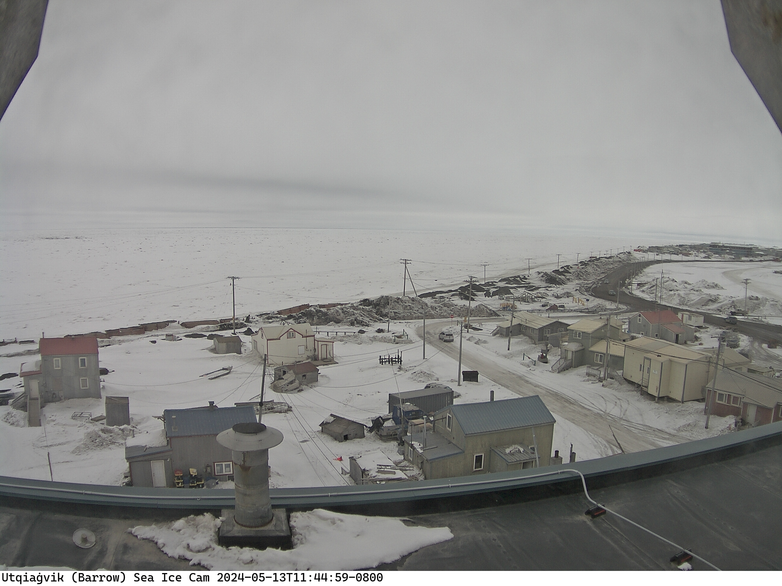
The seven day isn’t looking so hot for Barrow. Or actually it is, but not in the way we’d like. Note the average high in August is 44.Some sea ice at Pt. Barrow coming in?

Because if permafrost they can’t build like we do here with foundations, etc.That is just plain ugly, those houses, WTF>?
The good news going into this winter is that it literally can’t get any worse than the last one. 0” and scorching temperatures nearly throughout seems like the worst we can possibly do, right? Right? ?