-
Hello, please take a minute to check out our awesome content, contributed by the wonderful members of our community. We hope you'll add your own thoughts and opinions by making a free account!
You are using an out of date browser. It may not display this or other websites correctly.
You should upgrade or use an alternative browser.
You should upgrade or use an alternative browser.
Tropical Tropical Storm Barry
- Thread starter accu35
- Start date
pcbjr
Member
So long as "it" gets no name, everyone wins ...Alright guys, here we go. Euro west GFS east, who will win? Let the games begin.
Alright guys, here we go. Euro west GFS east, who will win? Let the games begin.
Also, Euro/EPS mean much stronger than GFS/GEFS mean and CDN GEPS mean. This will tell us a fair bit about the current version of the Euro.
pcbjr
Member
Can we get this thread on the main page?
Brent
Member
Huge EPS spread to say the least Texas to SC lol
Hopefully it doesn't get too organized, but some of us in the Deep South could use a little break from the endless scorching heat we've had the last week or so.
Tarheel1
I TOLD YALL IT WASN’T GOING TO SNOW
Member
2024 Supporter
2017-2023 Supporter
2025 Supporter
Should go right around the Bermuda high, into SE , and move NE, based on this mapHuge EPS spread to say the least Texas to SC lolView attachment 20861
GFS trended west.
Brent
Member
GFS trended west.
Definitely closer to the Euro now though still weaker

pcbjr
Member
looks like a ragged summer thunder line ... just hope in reality and not in cartoon models, that's what "it" ends up being ...
Last edited:
As a result of the further west 18Z GFS track as well as very slow movement, the AL, far SE MS, and W FL panhandle rainfall is ominously high. Even N GA gets 3-5". So, a big flood threat, especially for AL, IF this were to verify. Make sure your boats are ready just in case! But this is a Happy Hour run. So, you, of course, have SouthernWx's permission to toss as always.
pcbjr
Member
Bama Ravens
Member
I’m watching more days of my beach trip get washed away. I’m sure the rain lovers around here who want rain every day during the summer will be happy, though.
The dichotomy between the EPS and GEFS/GEPS continues as the Happy Hour GEFS is still another one with zero members (out of ~21) with SLP of 1003 mb or lower!
Edit: I actually now see one sub 1003 member (hits TX) on the Tidbits source that my source showing sub 1004s doesn't have...maybe that's because it is a control run that my source ignores. Still, there's a big contrast to the EPS though this GEFS run was slightly stronger vs earler runs and and also is further west.
Edit: I actually now see one sub 1003 member (hits TX) on the Tidbits source that my source showing sub 1004s doesn't have...maybe that's because it is a control run that my source ignores. Still, there's a big contrast to the EPS though this GEFS run was slightly stronger vs earler runs and and also is further west.
Last edited:
Brent
Member
Tropical Weather Outlook
NWS National Hurricane Center Miami FL
800 PM EDT Sun Jul 7 2019
For the North Atlantic...Caribbean Sea and the Gulf of Mexico:
A trough of low pressure located over the southeastern United States
is forecast to move southward toward the northeastern Gulf of
Mexico, where a broad area of low pressure will likely form in a few
days. Some gradual development is possible thereafter and a tropical
depression could form by the end of the week while the low meanders
near the northern Gulf Coast. Regardless of development, this system
has the potential to produce heavy rainfall along portions of the
central and eastern U.S. Gulf Coast later this week. For more
information about the rainfall threat, please see products issued by
your local weather forecast office and the Weather Prediction
Center. Interests along the northern Gulf Coast and Florida
peninsula should monitor the progress of this system.
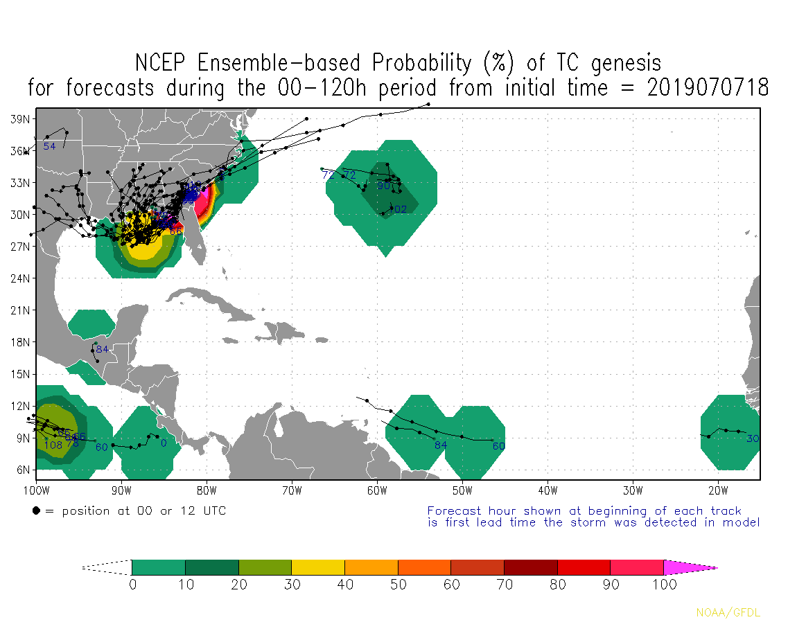
* Formation chance through 48 hours...low...near 0 percent.
* Formation chance through 5 days...medium...60 percent.
NWS National Hurricane Center Miami FL
800 PM EDT Sun Jul 7 2019
For the North Atlantic...Caribbean Sea and the Gulf of Mexico:
A trough of low pressure located over the southeastern United States
is forecast to move southward toward the northeastern Gulf of
Mexico, where a broad area of low pressure will likely form in a few
days. Some gradual development is possible thereafter and a tropical
depression could form by the end of the week while the low meanders
near the northern Gulf Coast. Regardless of development, this system
has the potential to produce heavy rainfall along portions of the
central and eastern U.S. Gulf Coast later this week. For more
information about the rainfall threat, please see products issued by
your local weather forecast office and the Weather Prediction
Center. Interests along the northern Gulf Coast and Florida
peninsula should monitor the progress of this system.
* Formation chance through 48 hours...low...near 0 percent.
* Formation chance through 5 days...medium...60 percent.
pcbjr
Member
Very time sensitive and it's far too big to attach the run, but you can see what "it" is looking like on one model ...
http://wxmaps.org/pix/precip_anim_subdomain.gif
http://wxmaps.org/pix/precip_anim_subdomain.gif
The NHC seems to like the idea of an eastern track with this system
They obviously haven't seen the Wilkesboro model yet.The NHC seems to like the idea of an eastern track with this system
Brent
Member
The NHC seems to like the idea of an eastern track with this system
maybe not, this from the WPC discussion
Elsewhere, the Pacific NW continues to be well agreed upon for a
general model blend. As for the Southeast, the 12z ECMWF trended a
bit faster rotating around the ridge and further southwest into
the Gulf by 84hrs compared to the 00z run; it remains well south
of the NAM but accompanied by the CMC/UKMET with the GFS still
splitting the difference between the NAM/ECMWF. WPC/NHC
preferences are more toward the southern solutions and away from
the NAM, but overall the spread is small to support a general
model blend with lower weight to the NAM.
The circle is so far east probably because if it did go west it'd be beyond day 5(which is as far as their outlook goes)
I would say west is more likely. These types of early GOM systems tend to take much longer to organize than the models predict. Dont be surprised if Houston isnt the target.
They also are very east side heavy, so actual landfall point is mostly moot.
They also are very east side heavy, so actual landfall point is mostly moot.
Storm5
Member

Sent from my iPhone using Tapatalk
pcbjr
Member
If counting correct, that's 13 in 43 years ... sounds like snow in Wake ... or rain at Shetly's ...
Sent from my iPhone using Tapatalk

pcbjr
Member
Like the analysis, not the maps ...
NAM is just crazy in hurricane season.FWIW 0z Nam little stronger than 18z, but it's the long range Nam and doesn't it suck at tropical systems?
Also, The ICON has trended south and stronger through 96.
NWMSGuy
Member
The Rainfall totals on the EURO look pretty impressive. I see a 23" total for a portion of southern MS.
ICON strengthens it into a hurricane and hits Louisana through 135.
Brent
Member
GFS is extremely weak, basically nothing again lol
It is SOUTH of Louisiana at 96 and looks Texas bound???
It is SOUTH of Louisiana at 96 and looks Texas bound???
Snowflowxxl
Member
Didn’t the old GFS have a problem of making storms WAY too strong? Like it used to through out 900mb storms on the usual?
Brent
Member
Didn’t the old GFS have a problem of making storms WAY too strong? Like it used to through out 900mb storms on the usual?
yeah now it seems to have the opposite problem of ignoring them...
UKMET into Mobile as a hurricane it appears
Last edited:
This all depends on this col type pattern, whether there’s more interaction from lower mslp from a front, or more high pressure above/around it slowing it down allowing it to sit in gulf a lot longer and having less interaction from the front, which would give it more tropical characteristics and a much more organized storm, only thing it would battle would be upwelling and shallow water, icon does not have much frontal interaction and lets this thing sit out there and strengthen, been noticing on models They keep it strengthening around/on the coast, even tho there’s shallow water, it’s warm 
Brent
Member
GFS going to Corpus Christi

This is a sensitive ass pattern, one change with the fropa and it could weaken the storm, or not much interaction and it would strengthen, it’s not much in between
GFS trended west to the Texas coast.
Brent
Member
Code Red!.png")
Brent
Member
The Euro is Texas bound! its so far west it hits me lmao
.png")
.png")
Last edited:
That kind of track, and slow storm forward speed, could spell flooding troubles all along the northern Gulf coast.
Sent from my SM-G950U using Tapatalk
This is now Invest 92L.