-
Hello, please take a minute to check out our awesome content, contributed by the wonderful members of our community. We hope you'll add your own thoughts and opinions by making a free account!
You are using an out of date browser. It may not display this or other websites correctly.
You should upgrade or use an alternative browser.
You should upgrade or use an alternative browser.
Tropical Subtropical Storm Alberto
- Thread starter stormcentral
- Start date
LetItSnow
Member
BPATL
Member
Alberto looks to be drifting NNE
Ok this was funny...
Sent from my SM-G920V using Tapatalk
Sent from my SM-G920V using Tapatalk
000
WTNT31 KNHC 281151
TCPAT1
BULLETIN
Subtropical Storm Alberto Intermediate Advisory Number 13A
NWS National Hurricane Center Miami FL AL012018
700 AM CDT Mon May 28 2018
...ALBERTO MOVING SLOWLY NORTHWARD TOWARD THE COAST OF THE
FLORIDA PANHANDLE...
SUMMARY OF 700 AM CDT...1200 UTC...INFORMATION
----------------------------------------------
LOCATION...29.0N 86.0W
ABOUT 100 MI...165 KM SSE OF DESTIN FLORIDA
MAXIMUM SUSTAINED WINDS...65 MPH...100 KM/H
PRESENT MOVEMENT...N OR 360 DEGREES AT 6 MPH...9 KM/H
MINIMUM CENTRAL PRESSURE...991 MB...29.26 INCHES
WATCHES AND WARNINGS
--------------------
CHANGES WITH THIS ADVISORY:
None
SUMMARY OF WATCHES AND WARNINGS IN EFFECT:
A Storm Surge Watch is in effect for...
* Suwannee River to Navarre Florida
A Tropical Storm Warning is in effect for...
* Suwannee River to the Mississippi/Alabama border
A Storm Surge Watch means there is a possibility of life-
threatening inundation, from rising water moving inland from the
coastline, in the indicated locations. For a depiction of areas at
risk, please see the National Weather Service Storm Surge
Watch/Warning Graphic, available at hurricanes.gov.
A Tropical Storm Warning means that tropical storm conditions are
expected somewhere within the warning area.
For storm information specific to your area, including possible
inland watches and warnings, please monitor products issued by your
local National Weather Service forecast office.
DISCUSSION AND OUTLOOK
----------------------
At 700 AM CDT (1200 UTC), the center of Subtropical Storm Alberto
was located near latitude 29.0 North, longitude 86.0 West. Alberto
is moving northward near 6 mph (9 km/h). A faster northward or
north-northwestward motion is expected during the next few days. On
the forecast track, the center of Alberto will cross the northern
Gulf Coast in the warning area this afternoon or evening. After
landfall, the system is forecast to move well inland into the
Tennessee Valley on Tuesday and into the Ohio Valley and Great Lakes
region on Wednesday and Thursday.
Maximum sustained winds are near 65 mph (100 km/h) with higher
gusts. Little change in strength is expected before Alberto reaches
the northern Gulf Coast later today. Steady weakening is forecast
after landfall, and Alberto will likely become a subtropical
depression tonight or early Tuesday and degenerate into a remnant
low by Tuesday afternoon.
Winds of 40 mph extend outward up to 105 miles (165 km) from the
center. An elevated observing station located about 15 miles (25
km) south of Apalachicola, Florida, has recently reported sustained
winds of 46 mph (74 km/h). A wind gust to 39 mph (63 km/h) was
recently observed at Apalachicola, Florida.
The estimated minimum central pressure from reconnaissance aircraft
data is 991 mb (29.26 inches).
HAZARDS AFFECTING LAND
----------------------
RAINFALL: Alberto is expected to produce the following rain
accumulations through Tuesday:
Central Cuba...Additional 5 to 10 inches, isolated storm-totals of
20 to 25 inches.
The Florida panhandle into much of Alabama and western Georgia...4
to 8 inches, isolated 12 inches.
The Florida Keys and Florida peninsula...Additional 1 to 4 inches,
isolated 10 inches.
Rest of the Southeast and Tennessee Valley into the lower mid
Atlantic from Tennessee east through the Carolinas...2 to 6 inches.
Rains in Cuba could produce life-threatening flash floods and
mudslides. Flooding and flash flooding are possible in the
southeast United States, including Florida.
WIND: Tropical storm conditions will spread across the warning area
throughout the day.
STORM SURGE: The combination of storm surge and the tide will cause
normally dry areas near the coast to be flooded by rising waters
moving inland from the shoreline. The water could reach the
following heights above ground somewhere in the indicated
areas if the peak surge occurs at the time of high tide...
Suwannee River to Navarre Florida...2 to 4 ft
The deepest water will occur along the immediate coast. Surge-
related flooding depends on the relative timing of the surge
and the tidal cycle, and can vary greatly over short distances. For
information specific to your area, please see products issued by
your local National Weather Service forecast office.
TORNADOES: A couple of brief tornadoes are possible today from
northern Florida into central and southern Georgia, southern South
Carolina, and southeastern Alabama.
SURF: Swells generated by Alberto will continue to affect the
eastern and northern Gulf Coast through Tuesday. These swells are
likely to cause life-threatening surf and rip current conditions.
For more information, consult products from your local weather
office.
NEXT ADVISORY
-------------
Next complete advisory at 1000 AM CDT.
$$
Forecaster Brown
ForsythSnow
Moderator
Alberto is definitely still going NE. Hurricane hunters just passed the center again and it has inched NE since the previous one.
I doubt any huge rainfall totals verify inland . This thing is gonna start speeding up once inland and will almost be in Tennesse by tomorrow night . Far cry from when the models were trying to stall it over the southeast
Sent from my SM-J327VPP using Tapatalk
Sent from my SM-J327VPP using Tapatalk
Lol JB ......

Sent from my SM-J327VPP using Tapatalk

Sent from my SM-J327VPP using Tapatalk
ForsythSnow
Moderator
Lol he thinks 5pm?! What a joke. This storm should make landfall around 1 or 3 I would say at the latest. He busted horribly.Lol JB ......
Sent from my SM-J327VPP using Tapatalk
jaymackd3
Member


BPATL
Member
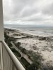
View attachment 5322 View attachment 5323 In gulf shores this morning down by fort Morgan. Light breeze about 10mph. Surf is up some but otherwise no big deal here. Sun is trying to peak out at times.
On the west side of the storm is usually the most tame,,,you know that. But this Alberto is really a kitten...
What a weird storm. Lol but definitely one to learn from. Sun trying to pop out.
RollTide18
Member
I agree, the inland storm totals will be impressive, but not nearly as much as models had forecast IMHO
NoSnowJoe
Member
I noticed on the last update at 11:00 it is now moving North instead of NNW. If it continues that motion it would bring it much closer to Georgia. Do you guys think it’s going to curve back NNW as the forecast is calling for?What a weird storm. Lol but definitely one to learn from. Sun trying to pop out.
GeorgiaGirl
Member
So odd that the core hasn't really gotten going but the bands of Alberto are gone. But that's a subtropical storm for you, I guess. May have picked up 0.5-1" last night but we've already had a lot of rain lately.
2.02" last night. So I was wrong.
2.02" last night. So I was wrong.
Last edited:
DadOfJax
Member
I noticed on the last update at 11:00 it is now moving North instead of NNW. If it continues that motion it would bring it much closer to Georgia. Do you guys think it’s going to curve back NNW as the forecast is calling for?
Yes...it will turn.
BPATL
Member
NNE
BPATL
Member
Bands rapidly increasing in GA, not AL????
https://radar.weather.gov/ridge/radar.php?rid=FFC&product=N0R&overlay=01101111&loop=yes
https://radar.weather.gov/ridge/radar.php?rid=FFC&product=N0R&overlay=01101111&loop=yes
Brent
Member
definitely a weird start to the season
now what's next
now what's next