• Hello, please take a minute to check out our awesome content, contributed by the wonderful members of our community. We hope you'll add your own thoughts and opinions by making a free account!

Tropical Subtropical Storm Alberto

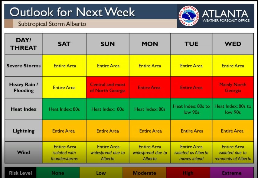
Going waayyyy out on a limb here, but until we have a couple runs and a bit more data, the "landfall" spot is still up for grabs; relying on a 1st advisory is not good poker; one thing's for certain though, "landfall" is not the key -- it's east and north-east of there that will get the worst weather.
 
Last edited:
Let's try not to spam up the thread with recon info. Only post it once if there is something significant.

The efforts are appreciated but I agree with this because too many of these will clog up the thread with data that many likely aren't knowledgeable enough about to decipher. If this were almost exclusively a tropical wx bb with several threads on each storm and if there were a dedicated thread to recon obs, that would be a totally different story. But we have only one Alberto thread.

However, this brings up a question: Do we want to have multiple Alberto threads now, including one for general discussion, one for just recon, one for just models, a later one for obs if there's landfall, etc?
I think we should stick to 1 for pre landfall, and one for obs and impacts. For now, it's mixed with the wet period thread, but could be split if it's best.
 
I personally like seeing the recon data . Maybe we can start recon obs thread

Sent from my SM-J327VPP using Tapatalk
 
I personally like seeing the recon data . Maybe we can start recon obs thread

Sent from my SM-J327VPP using Tapatalk

Agreed. I don't know what the issue is as you have to expand it to see it all, other wise it's the same size as the post I'm making.
 
Agreed. I don't know what the issue is as you have to expand it to see it all, other wise it's the same size as the post I'm making.

Yes but there could be dozens of these type posts covering just one flight. If that many are going to be posted, I think a separate recon thread would be best. Or limit it to just a vortex data message, which would often mean just one per flight. Example:

https://www.nhc.noaa.gov/text/MIAREPNT2.shtml


000
URNT12 KNHC 252028
VORTEX DATA MESSAGE AL012018
A. 25/19:50:50Z
B. 18 deg 46 min N
086 deg 17 min W
C. 925 mb 745 m
D. 22 kt
E. 043 deg 105 nm
F. 244 deg 14 kt
G. 043 deg 105 nm
H. EXTRAP 1006 mb
I. 17 C / 1525 m
J. 22 C / 746 m
K. 22 C / NA
L. NA
M. NA
N. 1345 / 9
O. 0.02 / 3 nm
P. AF307 0101A ALBERTO OB 06
MAX OUTBOUND AND MAX FL WIND 23 KT 222 / 56 NM 20:11:00Z
SLP EXTRAP FROM 925 MB
MAX FL TEMP 23 C 200 / 12 NM FROM FL CNTR
;
 
Last edited:
Yes but there could be dozens of these type posts covering just one flight. If that many are going to be posted, I think a separate recon thread would be best. Or limit it to just a vortex report.

If the thread is fast flowing I could understand, but if we are in the frame of a few posts an hour in the thread, why not have the data? To me it's much easier to keep it in the same thread and scroll by the posts than have to keep up with two or three threads on the same topic.
 
If the thread is fast flowing I could understand, but if we are in the frame of a few posts an hour in the thread, why not have the data? To me it's much easier to keep it in the same thread and scroll by the posts than have to keep up with two or three threads on the same topic.
Agree, but please folks, don't post quadruplicates of the exact same thing ... it's Friday afternoon and the eyes and brain get a bit glazed from the week already ... o_O

But for those with 20/20 and no headache (LOL) ... Here's 2 more really good links to follow for this (or any) tropical storm ...

http://www.atmos.albany.edu/facstaff/abrammer/maps/genesis/

http://flhurricane.com/cyclone/stormspotlight.php?year=2018&storm=1

PS - These are also in our little Wiki ...
 
Last edited:
If the thread is fast flowing I could understand, but if we are in the frame of a few posts an hour in the thread, why not have the data? To me it's much easier to keep it in the same thread and scroll by the posts than have to keep up with two or three threads on the same topic.

Over at another BB that I follow, they posted 25 recon obs posts before the vortex report over just a couple of hours but it is all contained in a dedicated recon obs thread. If that many were to be posted here, I'd think a dedicated thread would be better. If only a few, maybe not. That BB actually has two dedicated recon threads, recon obs and recon discussion, and 5 Alberto threads overall. But it is a much busier BB for tropical because it is almost purely tropical and more than a regional BB.

Edit: Remember, folks, that some people like to look back at these threads.
 
Last edited:
While we were discussing recon info, advisory 2 came out and the cone is east a bit. Now just a bit west of mobile and up a bit east of the MS AL border.
152536_5day_cone_no_line_and_wind.png
 
While we were discussing recon info, advisory 2 came out and the cone is east a bit. Now just a bit west of mobile and up a bit east of the MS AL border.
152536_5day_cone_no_line_and_wind.png
Also in our little Wiki, but a very good tool to judge trends ... https://www.nhc.noaa.gov/archive/ and to study later ...
You can watch all of the advisories and see if, how and where the cone shifts.

For this particular little storm ... https://www.nhc.noaa.gov/archive/2018/ALBERTO_graphics.php?product=5day_cone_with_line
 
ATLANTA

For our area, Alberto will bring heavy rainfall and the potential
for flooding. Although winds should not be a major issue with
Alberto, with already wet soils it will be relatively easy for
trees to fall. Current QPF associated with Alberto is about 3-6
inches with locally higher amounts possible, especially in
northeast GA and east central GA. Flash flooding will also become
a problem as well as river flooding. With the above-normal
rainfall that most areas have seen over the past few days, soils
are already saturated and additional precip would be expected to
cause problems. Make sure to be aware of any forecast
changes/watches/warnings, as well as updates from NHC, as there is
still uncertainty within the track of Alberto. The need for any
flood-related watches will continue to be monitored.
 
This has the potential to be another repeat of 1994 as far as rainfall. Alberto again...
Tropical Storm Alberto was the costliest storm of the 1994 Atlantic hurricane season. The storm was the first named storm of the season. It hit Florida across the Southeast United States in July, causing a massive flooding disaster while stalling over Georgia and Alabama. Alberto caused $1.03 billion in damage (1994 USD)[1] and 32 deaths.

Still have no answer as to why this name was not retired???
 
ATLANTA

For our area, Alberto will bring heavy rainfall and the potential
for flooding. Although winds should not be a major issue with
Alberto, with already wet soils it will be relatively easy for
trees to fall. Current QPF associated with Alberto is about 3-6
inches with locally higher amounts possible, especially in
northeast GA and east central GA. Flash flooding will also become
a problem as well as river flooding. With the above-normal
rainfall that most areas have seen over the past few days, soils
are already saturated and additional precip would be expected to
cause problems. Make sure to be aware of any forecast
changes/watches/warnings, as well as updates from NHC, as there is
still uncertainty within the track of Alberto. The need for any
flood-related watches will continue to be monitored.

Sounds reasonable, as the WPC has us up to 5 inches the next week. Also, the east shift will bring even more rain, so up to half a foot is possible. Need it after a few days of nothing. This will probably put the local lakes way higher again, as it's already a foot above. They may even have to do more frequent and longer releases as they did a few years ago when they let it get 4 feet above.
 
Looks like remnants going right over MBY, on about Wednesday, acording to the GFS! That’ll be good over the 1-2” I get between now and then!
 
Back
Top