There are some wind speeds approaching 90 mph above Person/Durham/Granville Counties, man the potential is there
-
Hello, please take a minute to check out our awesome content, contributed by the wonderful members of our community. We hope you'll add your own thoughts and opinions by making a free account!
You are using an out of date browser. It may not display this or other websites correctly.
You should upgrade or use an alternative browser.
You should upgrade or use an alternative browser.
Tropical Major Hurricane Michael
- Thread starter ForsythSnow
- Start date
Just had a gust to around 50 and that was it. Now just breezy.
That was solid
Sent from my SM-G955U using Tapatalk
Sent from my SM-G955U using Tapatalk
packfan98
Moderator
Lost power for two hours. Sun is out now. Bring on fall!
Blue_Ridge_Escarpment
Member
Sun is out and clearing has begun. Worst flooding here since 2004 when Frances and Ivan got us back to back. Now to how low can we go tonight. Low to mid 40s will feel perfect.
Webberweather53
Meteorologist
Rah just throwing out blanket severe t-storm warning to cover this quick hitting band of wind..... I know this is associated with a TC transitioning to extra-tropical but this is like a derecho
Derechos are usually driven by strong rear inflow jets from very deep, very long-lived convective complexes. This seems to be more along the lines of what you'd anticipate w/ a sting jet which I mentioned earlier this morning. The winds were definitely influenced by similar derecho-esque processes in areas closer to the VA border though where deep convection persisted earlier today but the strong winds are also occurring in areas almost completely devoid of any deep convection, which implies another culprit is largely at work. The sudden drop in dew points as the wind gusts moved thru many places in central NC is a signature of a sting jet as the low-levels try to dry out and hydrometeor loading superimposes onto evaporative cooling to create large-scale downdrafts that mix stronger winds down from aloft. You often see a deformation/"hook-like" appendage orientated from south-north on the back end of an area of rather intense (& often rapidly deepening) area of low pressure. Here, this rapidly deepening low we often see in sting jets may be compensated for by isallobaric processes as local pressure gradients tightened on the NW side of Michael, often more akin to what you'd see in an extratropical cyclone of course.
On the other hand, I still believe while there's definitely thermal advection across Michael atm and the +PV anomalies are becoming zonally extensive wrt the tropopause (potentially indicative of extratropical transition), there's still a pretty decent low-level, diabatic PV tower leftover in Michael so it's still a warm core, tropical system to a large extent. This is definitely starting to get into the gray area generally speaking.

Max gust on the front side was 33, 45 on the backside.
Sent from my SM-G955U using Tapatalk
Sent from my SM-G955U using Tapatalk
All the big stuff missed to the north of us. Your power ever come back on?Max gust on the front side was 33, 45 on the backside.
Sent from my SM-G955U using Tapatalk
It was on when I got home thankfully, been struggling though over the past 10 minutesAll the big stuff missed to the north of us. Your power ever come back on?
But yeah im happy the strong stuff missed to the north. I'm not sure we would get power back as quickly as we did with florence if it was taken out
Sent from my SM-G955U using Tapatalk
100 over granville now at 2300 ftVery high winds just a few thousand feet aloft above Durham County moving into Wake. Was able to find a few 100+ returns from the radar in Clayton at .5 ele.
Sent from my SM-G955U using Tapatalk
Webberweather53
Meteorologist
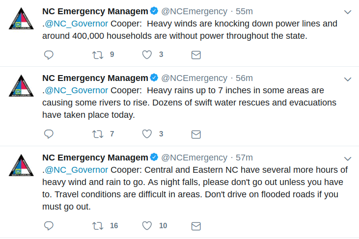
Nearly half a million people are w/o power now in NC.
We gusted to around 55 mph I would estimate
Yellow Snow
Member
I'm just in awe of the thrashing that Michael was able to give to NC today, after spending so many hours traversing over land...
I kept hearing an airplane and decided to see why. This has to suck for anyone flying and certainly for the pilots. Check out a few planes just hanging out


Sent from my SM-G955U using Tapatalk


Sent from my SM-G955U using Tapatalk
B
Brick Tamland
Guest
The big wind is here now.
Calm here right now, biggest gust so far........ 26 mphMax gust on the front side was 33, 45 on the backside.
Sent from my SM-G955U using Tapatalk
and the death band is weakening it would appear, not complaining just sayin
There are still some ripping winds just off the surface. That line just east of warrenton may be a problem for youCalm here right now, biggest gust so far........ 26 mph
and the death band is weakening it would appear, not complaining just sayin
Sent from my SM-G955U using Tapatalk
Yeah I see that, it does have me a tad concerned..... I'd actually like to keep my power on. Picked up 1.8 so far too, first rains since FlorenceThere are still some ripping winds just off the surface. That line just east of warrenton may be a problem for you
Sent from my SM-G955U using Tapatalk
Webberweather53
Meteorologist
About to cross the 600k mark for power outages in NC, unreal.