• Hello, please take a minute to check out our awesome content, contributed by the wonderful members of our community. We hope you'll add your own thoughts and opinions by making a free account!

Pattern Jarring January

40 of those frames have snow here, and it's the correct time frame as well! I'm going to jump aboard this train, but I have a fear that those models with a sharp cutoff around here is a possibility. Those warm noses are pains.

I second this. This makes me very uncomfortable for my area.


Sent from my iPhone using Tapatalk
 
I second this. This makes me very uncomfortable for my area.


Sent from my iPhone using Tapatalk
Yeah, at this point, I'm hoping this winter could go down as the one in which (almost) every member got snow. We only have a few places in which it hasn't snowed at all, and that's central SC though the upstate, and then west into Texas and AR.
 
Yeah, at this point, I'm hoping this winter could go down as the one in which (almost) every member got snow. We only have a few places in which it hasn't snowed at all, and that's central SC though the upstate, and then west into Texas and AR.

Phil got a tiny bit of ZR but no SN or IP I think.
 
Lol RDU is on the SE side of the EPS at day 5, we know how this story usually ends...
Yeah. It doesn't matter how it starts out for central NC it seems to almost always end as climo. I'll be surprised if I get more that the 1/2" of snow I got last week.
 
So it seems right now as if GFS/Euro/NAVGEM are in the camp of showing a system but CMC/UKMET aren't. Haven't the CMC and UKMET been more reliable this winter?
 
Tony,
Very little damage but it was headed there. I roughly estimate that there was as much as 0.25" of ice buildup on some limbs from the up to 0.50" of ZR. Power was starting to go in a few areas when it finally transitioned to sleet.
Glad it wasn't full accretion like in 73. Still, a quarter can get scary, so I'm glad you dodged the bullet, and got the sleet....the good stuff, lol. I hope, at least, you got someone to pull you behind the car attached to a rope....and on a sled, or pizza pan. Just tying a rope to yourself, and getting some one to pull you on ice, won't work as well, lol. T
 
Well this is not like a typical scenario where the mix line is cutting through Wake County. Sure, I guess we could get the shaft yet again on the precip, but I'll take my chances with this setup if it verifies.
And if the GFS is more correct with the wider field of higher totals, it doesn't matter anyway.
 
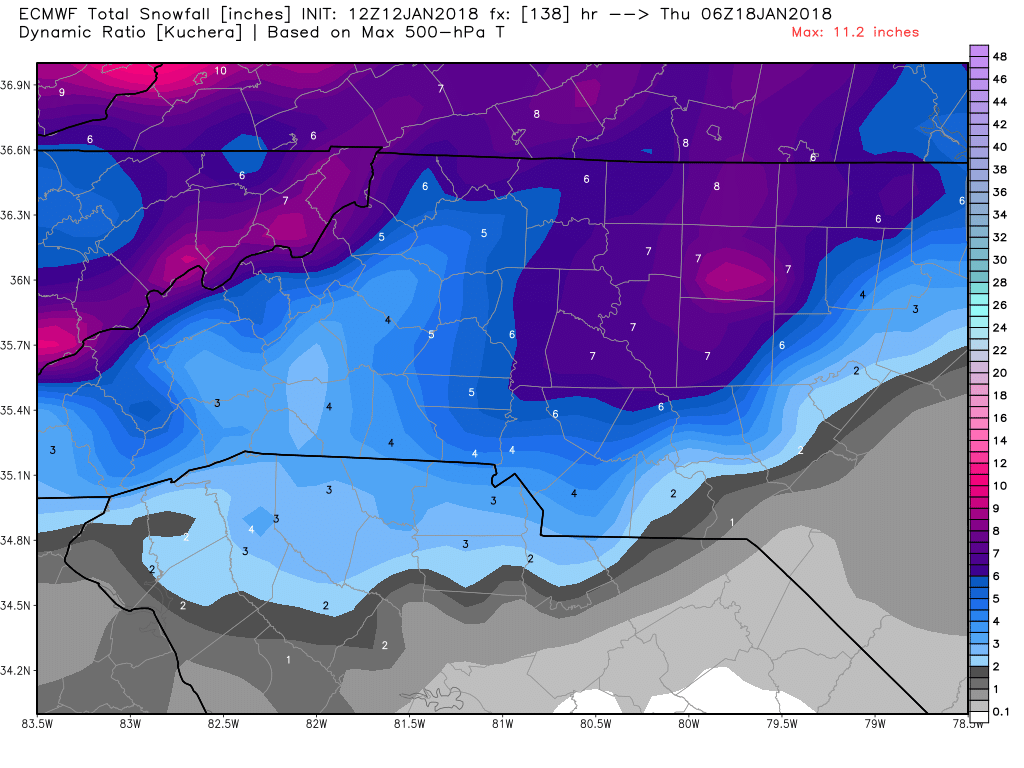
Here's the 12z Kuchera map. The one I posted a minute ago was the 0z by mistake.
ecmwf_tsnow_KU_charlotte_24.png.30a3f83f673a927e00550e62b764ed95.png
Sorry but can you post the map through the end of the run to include central/eastern sections?

Sent from my SM-G920V using Tapatalk
 
Here's the AFD from Raleigh:

Models are coming into better alignment Tuesday into Wednesday for
the H5 trough to develop a closed low anywhere from the Ohio Valley
to the MidAtlantic region. This scenario brings a much better
chance for higher QPF over central North Carolina with a
sufficiently cold airmass in place. For now, will introduce a chance
for snow Tuesday night into Wednesday. The further west the closed
low forms, the greater the possibility that precipitation east and
south of the Triangle will mix with or be all rain.
 
The trend continues. Though slower than the GFS suite, the 12Z EPS is now slowly increasing western US ridging late in its run/late month. Give it a few runs and it is liable to have full strength western ridging/E troughing based on recent trends. My analog based warm dominated SE US forecast after 1/15 is quickly going down the johnny.
 
LOL but I don't want to be in a snow hole. If you want bad talk, then it's going to be too dry and it's going to disintegrate. There will be no storm.
The snow hole is the best possible place to be at this point. I was in the bullseye in the Dec storm right until show time. How did you do in that storm? I got a t shirt that said, "sucker", on it, lol.
 
Back
Top