Looks like some good rain next weekend before the arctic front blasts through.
Sent from my SM-J320VPP using Tapatalk
Sent from my SM-J320VPP using Tapatalk
Must be drunk on the strongest liquor our there!
I disagree with you on March, but generally our region's biggest storms from a historical perspective have always been in February. One has to look no further than 2010, 1973, 1914, 1899, 1980, and 1912 in order to realize that this is generally whenever the magic occurs at a greater frequency for areas within Middle Georgia. I'm pretty sure the last time that Middle Georgia recorded snow in March was from the March 1, 2009 and that was limited to a dusting from Macon south and very limited totals in other parts of the region.January brings the all snow events their usually lighter totals and bring the powder snow. February seems to always have the big storms sometimes they can be a mix but their big. March no matter what it seems to always be big it may only come once every 5 years but it's the biggest storm in that 5 year span. That's what it always seems like at least for middle Georgia
Yeah, got a Wow out of meThe 18z GFS is nuts. Expect some insane model runs incoming.
") Glad I've been getting up fire wood, for that extra toasty feeling.
Glad I've been getting up fire wood, for that extra toasty feeling.Ive seen it snow at 51LMAO I just showed this to my dad and he said "There's no way that this is actually true. This is a mistake by the model".
(Which I decided to investigate and honestly it might have been. Temps don't really support it. I can see snow at 40 but 46? Naahhh (that's what I saw when I pulled a sounding) Then again I think I saw snow grains at 48 before in the past so perhaps this isn't that stupid.
I didn't know you were that old, yet ...Ive seen it snow at 51
Sorry for that. It's no fun. I finally got to where I run the water, not drip, hours before sundown of a cold day. Got real tire of lying on my back in water fixing pipes. I'd rather pay for a heater load of hot water, because it's the hot water that freezes. Those tiny little pvc marvels, lol, but run enough water thru them and they won't freeze.im sorry but after my water froze and busted my pipe and flooded my house last friday im done with cold. dont want no more this year
LMAO I just showed this to my dad and he said "There's no way that this is actually true. This is a mistake by the model"
(Which I decided to investigate and honestly it might have been. Temps don't really support it. I can see snow at 40 but 46? Naahhh (that's what I saw when I pulled a sounding) Then again I think I saw snow grains at 48 before in the past so perhaps this isn't that stupid.
I’m definitely optimistic that models are seeing good trends down the road. I won’t get to excited yet as we still have a ways to go but I’m definitely happy we aren’t seeing signs of a torch.I see the Happy Hour got drunk off of it's delicious wines.
Edit: If this run were to verify our guys like olhausen and others in that area are going to be happy. It's still a bit out there though.
We had 4 inches up here in Jones County the most snow I've ever seen or at least can rememberI disagree with you on March, but generally our region's biggest storms from a historical perspective have always been in February. One has to look no further than 2010, 1973, 1914, 1899, 1980, and 1912 in order to realize that this is generally whenever the magic occurs at a greater frequency for areas within Middle Georgia. I'm pretty sure the last time that Middle Georgia recorded snow in March was from the March 1, 2009 and that was limited to a dusting from Macon south and very limited totals in other parts of the region.
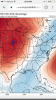
Good reason, one of many, not to take maps verbatim ...It's not snow in south FL. If you notice it says "twelve hour average precipe rate". That verbatim is just a really strong cold front. So your original thought is correct.
This is pretty much the same thing that used to happen. The old thing was to post precipitation maps with the 0C line at 850mb south of the QPF field and call it snow. We would do a post every year about how the precip fell in the 6-12hrs previous of that image.
This is the 18z GEFS mslpI'll take it. Esp with that trof moving in during the period. Trend has been nw on the northern low (more separation), lagging shortwave, and stronger secondary low. We track!
 0z throwing us a bone.
Hook, line, and sinker. LolLol the ole day 9/10 rain changing snow.
Sent from my SM-J320VPP using Tapatalk