ForsythSnow
Moderator
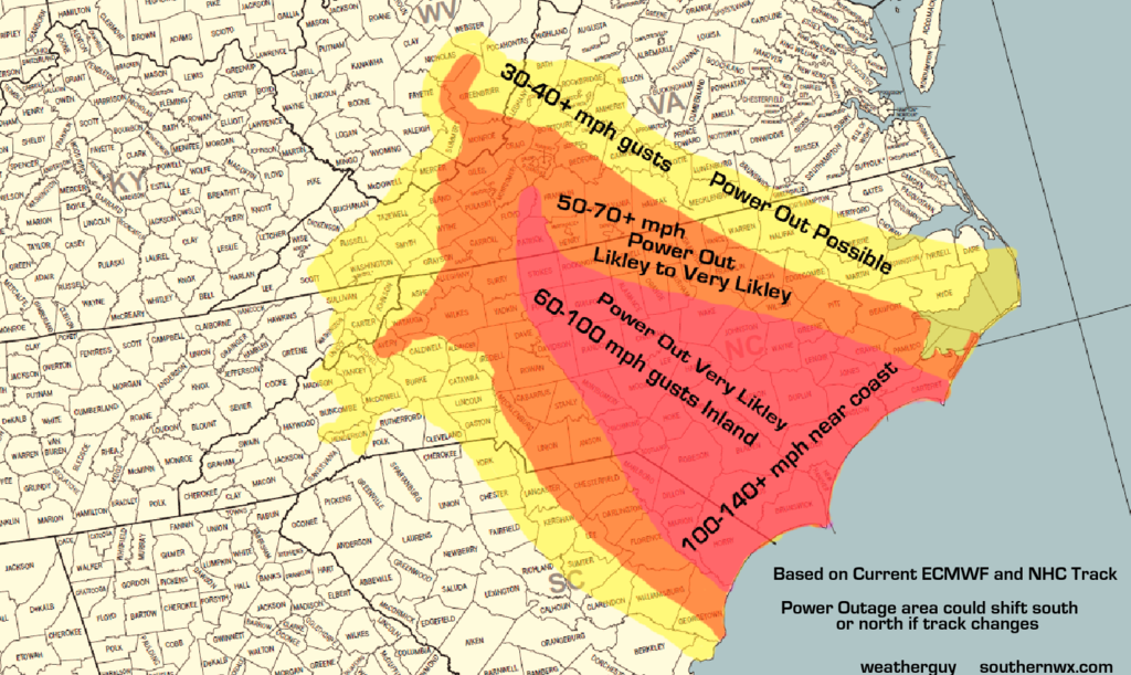
Post any you make or have ideas for here.


You think their will big shift south?I will give it a go. EURO still a bit on southern end....I think that looks pretty good for now, IMO


I actually didn't do too bad on the last part of the map. Florence followed almost in the dead center of the cone I made except for crawling down the coast a bit further. The intensity on the weakening scenario was pretty close too. I should keep in mind with what models predicted and how some were too far north and others too far south. Taking the middle road may be the way to go, but next year we won't have the GFS, as the FV3 replaces it.Here's my last map.
1. Intensities are not ranges, they are 2 different scenarios. One is the storm keeps weakening, the other is the storm strengthens back to a cat 4.
2. The yellow line is where the models want to take it at the moment averaged to some degree and where the current trend may take it.
In case you can't read the numbers because the colors are hard to see :
125 mph (Now)
120 - 140 mph
115 - 145 mph
100 - 130 mph
90 - 115 mph
45 - 60 mph
25 - 35 mph
View attachment 6289
Ya did real good, FS! Kudos ...I actually didn't do too bad on the last part of the map. Florence followed almost in the dead center of the cone I made except for crawling down the coast a bit further. The intensity on the weakening scenario was pretty close too. I should keep in mind with what models predicted and how some were too far north and others too far south. Taking the middle road may be the way to go, but next year we won't have the GFS, as the FV3 replaces it.
")