-
Hello, please take a minute to check out our awesome content, contributed by the wonderful members of our community. We hope you'll add your own thoughts and opinions by making a free account!
You are using an out of date browser. It may not display this or other websites correctly.
You should upgrade or use an alternative browser.
You should upgrade or use an alternative browser.
Wintry Winter Storm Call maps
- Thread starter deltadog03
- Start date
that’s very close to what I’m thinking so I’m not even gonna do one. Good job. I’m watching for any last minute qpf reductions in case heavy snow amounts do not occur north of i40.
Then why Mt .Rodgers? I get the warm nose thing but I'd seriously consider highlands Brevard area.that’s very close to what I’m thinking so I’m not even gonna do one. Good job. I’m watching for any last minute qpf reductions in case heavy snow amounts do not occur north of i40.
ATLwxfan
Member
Looks pretty good. Not too sure about the backside sleet or snow for GA and points west into AL. End of the NAM was meh. Maybe it juices up but I’m not too enthused.
Sent from my iPhone using Tapatalk
Sent from my iPhone using Tapatalk
LukeBarrette
im north of 90% of people on here so yeah
Meteorology Student
Member
2024 Supporter
2017-2023 Supporter
Come up to Roanoke! We are right on the line for sleet. If there is any shift SE in the models then we are all snow going from 10 inches to 16 inches most likelythat’s very close to what I’m thinking so I’m not even gonna do one. Good job. I’m watching for any last minute qpf reductions in case heavy snow amounts do not occur north of i40.
It’s just very close to home to me and it’s the highest elevation in the state of Virginia. It’s a unique spot not many realize it’s practically on our state border and I prefer to stay with NWS Blacksburg since they cover Wilkes.Then why Mt .Rodgers? I get the warm nose thing but I'd seriously consider highlands Brevard area.
LickWx
Member
Are you saying your going to be on top of a 5000 foot mountain that’s all wilderness in the middle of a major storm ?It’s just very close to home to me and it’s the highest elevation in the state of Virginia. It’s a unique spot not many realize it’s practically on our state border and I prefer to stay with NWS Blacksburg since they cover Wilkes.
That's the reason he is worried about connecting with emergency services.
Idk why my reply said bull city ex lolIt’s just very close to home to me and it’s the highest elevation in the state of Virginia. It’s a unique spot not many realize it’s practically on our state border and I prefer to stay with NWS Blacksburg since they cover Wilkes.
ATLwxfan
Member
Looks pretty good. Not too sure about the backside sleet or snow for GA and points west into AL. End of the NAM was meh. Maybe it juices up but I’m not too enthused.
Sent from my iPhone using Tapatalk
Obsolete
Sent from my iPhone using Tapatalk
Avalanche
Member
Do you have a CB radio? Just in case you get out of cell phone range its good to have for backup. Mine gets out about 50 miles. It can save a life.It’s just very close to home to me and it’s the highest elevation in the state of Virginia. It’s a unique spot not many realize it’s practically on our state border and I prefer to stay with NWS Blacksburg since they cover Wilkes.
iGRXY
Member

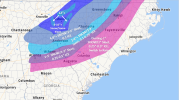
First call map. This is going to change no doubt. Mountains are going to get hammered with this storm. 12"+ totals especially along the BR parkway. Definitely think along and north of 85, especially in the upstate and the mountains of NE Georgia will finish with 4-6" of snow after the sleet cuts down on some of the totals. If you go measure outside with sleet included you probably will get above 6" in a lot of places. A glaze to 0.1" of ZR as well. along and SE of 85 and through the Central upstate I think 2-4" Should be a good bet especially with that backside band, but a lot more ICE and sleet. Through the southern upstate, midlands, and most of the I20 corridor is where I think we are set up for a Major Ice storm.
Good first call map. All in all, a big wintery messView attachment 105064
First call map. This is going to change no doubt. Mountains are going to get hammered with this storm. 12"+ totals especially along the BR parkway. Definitely think along and north of 85, especially in the upstate and the mountains of NE Georgia will finish with 4-6" of snow after the sleet cuts down on some of the totals. If you go measure outside with sleet included you probably will get above 6" in a lot of places. A glaze to 0.1" of ZR as well. along and SE of 85 and through the Central upstate I think 2-4" Should be a good bet especially with that backside band, but a lot more ICE and sleet. Through the southern upstate, midlands, and most of the I20 corridor is where I think we are set up for a Major Ice storm.
Good maps. If I did one the only difference I would make is 12-24” range from Crumpler NC into Virginia up and past Mount Rogers.
Iceagewhereartthou
Member
Great map and probably pretty close. It's been 2893 days since CAE recorded measurable snow/ice (Feb 12, 2014) will this break the streak?View attachment 105064
First call map. This is going to change no doubt. Mountains are going to get hammered with this storm. 12"+ totals especially along the BR parkway. Definitely think along and north of 85, especially in the upstate and the mountains of NE Georgia will finish with 4-6" of snow after the sleet cuts down on some of the totals. If you go measure outside with sleet included you probably will get above 6" in a lot of places. A glaze to 0.1" of ZR as well. along and SE of 85 and through the Central upstate I think 2-4" Should be a good bet especially with that backside band, but a lot more ICE and sleet. Through the southern upstate, midlands, and most of the I20 corridor is where I think we are set up for a Major Ice storm.
weather bubba
Member
Speaking for those of us who love having power in the pink area on your map, I hope this forecast does not pan out. At this time though I think your map is a pretty good call. It's time to start preparing for the worst and hoping for the best.View attachment 105064
First call map. This is going to change no doubt. Mountains are going to get hammered with this storm. 12"+ totals especially along the BR parkway. Definitely think along and north of 85, especially in the upstate and the mountains of NE Georgia will finish with 4-6" of snow after the sleet cuts down on some of the totals. If you go measure outside with sleet included you probably will get above 6" in a lot of places. A glaze to 0.1" of ZR as well. along and SE of 85 and through the Central upstate I think 2-4" Should be a good bet especially with that backside band, but a lot more ICE and sleet. Through the southern upstate, midlands, and most of the I20 corridor is where I think we are set up for a Major Ice storm.
LukeBarrette
im north of 90% of people on here so yeah
Meteorology Student
Member
2024 Supporter
2017-2023 Supporter
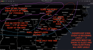
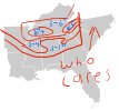
Looks like an alien ? lol good job thoughCall map 1
Just snow.


