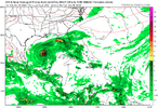
Significantly slower than GFS
GFS has it in Tampa at 108 whereas the Canadian is barely off the Yucatán lol. I’m more inclined to go with the GFS
0Z UK: best for track, not intensity! Much further S than GFS and near CMC. This goes ENE S of Naples (12Z was between Naples and Ft Myers). Reminds me of Ian, when UK was furthest SE days in advance and ended up best with Icon 2nd (But CMC was furthest NW near GFS)
NEW TROPICAL CYCLONE FORECAST TO DEVELOP AFTER 60 HOURS
FORECAST POSITION AT T+ 60 : 22.4N 91.0W
LEAD CENTRAL MAXIMUM WIND
VERIFYING TIME TIME POSITION PRESSURE (MB) SPEED (KNOTS)
-------------- ---- -------- ------------- -------------
1200UTC 07.10.2024 60 22.4N 91.0W 1003 30
0000UTC 08.10.2024 72 22.2N 89.3W 1001 27
1200UTC 08.10.2024 84 22.8N 87.4W 998 30
0000UTC 09.10.2024 96 23.6N 85.0W 997 31
1200UTC 09.10.2024 108 24.8N 82.5W 997 34
0000UTC 10.10.2024 120 26.5N 79.6W 998 36
1200UTC 10.10.2024 132 29.3N 75.2W 999 45
0000UTC 11.10.2024 144 30.6N 68.7W 1000 47
1200UTC 11.10.2024 156 31.7N 62.6W 1001 47
0000UTC 12.10.2024 168 32.8N 55.9W 1002 39

