• Hello, please take a minute to check out our awesome content, contributed by the wonderful members of our community. We hope you'll add your own thoughts and opinions by making a free account!

Tropical Tropical Depression Five

This one has certainly piqued my interest. A tiny circulation in a light-shear environment. I've seen these sneaky little systems ramp up in a hurry.

There is quite a bit of dry air over the continent that may impede rapid development. On the other hand, in the absence of shear to inject this nearby dry air into the system, it may not matter. Outflow developing in all quadrants. Interesting.
 
Getting in before @GaWx posts his system updates
NEW TROPICAL CYCLONE FORECAST TO DEVELOP AFTER 30 HOURS
FORECAST POSITION AT T+ 30 : 13.3N 110.7W

LEAD CENTRAL MAXIMUM WIND
VERIFYING TIME TIME POSITION PRESSURE (MB) SPEED (KNOTS)
-------------- ---- -------- ------------- -------------
0000UTC 01.09.2026 36 13.3N 111.4W 1005 33
1200UTC 01.09.2026 48 14.8N 112.7W 1005 37
0000UTC 02.09.2026 60 15.1N 114.7W 1003 31
1200UTC 02.09.2026 72 15.8N 116.0W 1003 36
0000UTC 03.09.2026 84 16.6N 117.7W 1001 38
1200UTC 03.09.2026 96 17.1N 119.0W 998 40
0000UTC 04.09.2026 108 18.0N 120.5W 995 41
1200UTC 04.09.2026 120 18.3N 121.8W 992 38
0000UTC 05.09.2026 132 19.1N 123.0W 991 38
1200UTC 05.09.2026 144 19.8N 123.8W 992 41
0000UTC 06.09.2026 156 20.7N 124.4W 994 45
1200UTC 06.09.2026 168 21.8N 124.4W 995 40

NEW TROPICAL CYCLONE FORECAST TO DEVELOP AFTER 102 HOURS
FORECAST POSITION AT T+102 : 26.5N 78.7W

LEAD CENTRAL MAXIMUM WIND
VERIFYING TIME TIME POSITION PRESSURE (MB) SPEED (KNOTS)
-------------- ---- -------- ------------- -------------
0000UTC 04.09.2026 108 27.5N 79.5W 1008 29
1200UTC 04.09.2026 120 29.2N 81.3W 1008 31
0000UTC 05.09.2026 132 30.8N 83.2W 1008 24
1200UTC 05.09.2026 144 32.0N 85.4W 1009 19
0000UTC 06.09.2026 156 32.8N 87.3W 1008 18
1200UTC 06.09.2026 168 33.1N 87.9W 1008 20

NEW TROPICAL CYCLONE FORECAST TO DEVELOP AFTER 120 HOURS
FORECAST POSITION AT T+120 : 15.8N 52.0W

LEAD CENTRAL MAXIMUM WIND
VERIFYING TIME TIME POSITION PRESSURE (MB) SPEED (KNOTS)
-------------- ---- -------- ------------- -------------
1200UTC 04.09.2026 120 15.8N 52.0W 1011 25
0000UTC 05.09.2026 132 16.9N 55.0W 1010 30
1200UTC 05.09.2026 144 17.8N 57.6W 1008 35
0000UTC 06.09.2026 156 19.3N 59.2W 1006 41
1200UTC 06.09.2026 168 20.8N 59.6W 1002 48
 
Getting in before @GaWx posts his system updates

Regarding the 3rd one on your 12Z UKMET list:

12Z UKMET for 2nd full run in a row has a TC originating in the W MDR well out in the run. 0Z had a TD but 12Z has a strengthening mid-grade TS as it recurves well away from any landmass due to a notable upper trough per H5 maps:

NEW TROPICAL CYCLONE FORECAST TO DEVELOP AFTER 120 HOURS
FORECAST POSITION AT T+120 : 15.8N 52.0W

LEAD CENTRAL MAXIMUM WIND
VERIFYING TIME TIME POSITION PRESSURE (MB) SPEED (KNOTS)
-------------- ---- -------- ------------- -------------
1200UTC 04.09.2026 120 15.8N 52.0W 1011 25
0000UTC 05.09.2026 132 16.9N 55.0W 1010 30
1200UTC 05.09.2026 144 17.8N 57.6W 1008 35
0000UTC 06.09.2026 156 19.3N 59.2W 1006 41
1200UTC 06.09.2026 168 20.8N 59.6W 1002 48
 
FWIW, NHC's latest outlook (as of 2pm) has tropical formation up to 50% before LF. Believe that is TD criteria instead of named TS though.
Regardless of if it gets named, fairly certain another instance of being downgraded less than 12-24 hrs. Been that kind of tropical season so far!
 
GOES16-GA-GEOCOLOR-1000x1000.gif
 
97L is a cherry. Warnings likely by morning.

1. Northern Gulf of America (AL97):
An area of low pressure located over the northern Gulf of America,
about 125 miles south of the coast of southeastern Louisiana,
continues to become better defined, and the associated shower and
thunderstorm activity is gradually increasing. Continued gradual
development is expected as the low moves slowly west-northwestward,
and a short-lived tropical depression or tropical storm is likely to
form before the system reaches the Upper Texas or southwestern
Louisiana coasts on Tuesday or Tuesday night.

Interests along the southwest Louisiana and Upper Texas coasts
should monitor the progress of this system, as tropical storm
watches or warnings could be required for portions of the area later
tonight or Monday morning. Regardless of development, this system is
expected to bring locally heavy rainfall to portions of the Upper
Texas and southwestern Louisiana coasts during the next several
days. An Air Force Reserve reconnaissance aircraft is scheduled to
investigate the low-pressure area on Monday morning.
* Formation chance through 48 hours...high...70 percent.
* Formation chance through 7 days...high...70 percent.
 
I am really not sure why this has no designation? This doesn’t have much time left over sea, but the radar look is classic for a potential strengthening into a hurricane from what I remember, yet…

We don’t have Edouard

We don’t have a TD

For now we don’t even have a PTC
 
I am really not sure why this has no designation? This doesn’t have much time left over sea, but the radar look is classic for a potential strengthening into a hurricane from what I remember, yet…

We don’t have Edouard

We don’t have a TD

For now we don’t even have a PTC
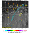
I presume the NHC is waiting on recon data later this AM, but I'm surprised they haven't designated 97L a PTC already, too. A PTC designation at 8AM is possible given the convective blowup occurring now. Nearby oil platforms all have rather weak winds and I didn't see any meaningful pressure falls. That said, it's a small circulation and higher winds are likely being missed by the sites I skimmed over this AM.

Still no PTC designation at the 8 AM update. Recon is inbound shortly.
 
Last edited:
I presume the NHC is waiting on recon data later this AM, but I'm surprised they haven't designated 97L a PTC already, too. A PTC designation at 8AM is possible given the convective blowup occurring now. Nearby oil platforms all have rather weak winds and I didn't see any meaningful pressure falls. That said, it's a small circulation and higher winds are likely being missed by the sites I skimmed over this AM.

Still no PTC designation at the 8 AM update. Recon is inbound shortly.

Yeah quite strange there's no PTC. This is literally what they made PTC's for(the old timers will remember a time before we even had PTC's)
 
Yeah quite strange there's no PTC. This is literally what they made PTC's for(the old timers will remember a time before we even had PTC's)

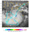
There has been theories floating around on Twitter about the federal government wanting to withhold a designation like that for the oil rigs within the area, which I would even go as far as to believe it because of how pricey everything oil-related is.
 
There has been theories floating around on Twitter about the federal government wanting to withhold a designation like that for the oil rigs within the area, which I would even go as far as to believe it because of how pricey everything oil-related is.
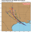
Meh. 15-knot winds don't even shut down fishing.
 
Getting close. It appears a TS is indeed coming together rather quickly now. Pressure falls have been meh, though (1013MB), so lets see if pressure falls commence.
1788193535305.png
 
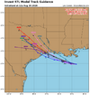
12Z UKMET and other global probably are of little value due to how tiny system is. But fwiw and for the record:

12Z UKMET initializes this as a TD:


TROPICAL DEPRESSION 05L ANALYSED POSITION : 28.3N 91.0W

ATCF IDENTIFIER : AL052026

LEAD CENTRAL MAXIMUM WIND
VERIFYING TIME TIME POSITION PRESSURE (MB) SPEED (KNOTS)
-------------- ---- -------- ------------- -------------
1200UTC 31.08.2026 0 28.3N 91.0W 1013 20
0000UTC 01.09.2026 12 27.9N 92.2W 1012 19
1200UTC 01.09.2026 24 29.2N 93.5W 1012 20
0000UTC 02.09.2026 36 CEASED TRACKING
 
Back
Top