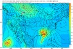
Some pretty good similarities at 250mb to Hurricane Zeta of 2020. Quite a bit different at 500mb though.


AI vs OPHAFS-A much stronger on the 12z run
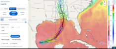
12 Google DeepMind suite is also in and it’s basically all along and East of Mobile. Has lost any western tracks entirely
View attachment 198488


Seems like DeepMind has been pretty consistent clustering on that FL panhandle track, while OPs have been noticeably towards MS/LA.HAFS-A much stronger on the 12z run
12 Google DeepMind suite is also in and it’s basically all along and East of Mobile. Has lost any western tracks entirely
View attachment 198488


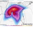
Still hurricane at landfall thoHere is the Google MSLP's. You can see they depict significant weakening on approach to landfall. The peak is well offshore
View attachment 198490
For sure. But just pointing out this could be different compared to recent years where it's felt like every single Hurricane just RI's right up to landfallStill hurricane at landfall tho

I was surprised they were that bullish.Very aggressive first forecast
72H 09/1800Z 28.5N 88.3W 85 KT 100 MPH


Given the rapidly improving satellite presentation, along with the Google and HWRF models, this makes sense. It's wasting no time organizing, which plays right into a faster NNE turn and speed.Very aggressive first forecast
72H 09/1800Z 28.5N 88.3W 85 KT 100 MPH

Worst case is a RIC followed by a ERC. Windfield would broaden further as it becomes extratropical after landfall.Given the rapidly improving satellite presentation, along with the Google and HWRF models, this makes sense. It's wasting no time organizing, which plays right into a faster NNE turn and speed.

I have a feeling those of us rain starved in central SC are gonna miss out yet again. Is there any hope guys?
The NHC hints at exactly this. There will be baroclinic forcing in play at and after landfall, too.Worst case is a RIC followed by a ERC. Windfield would broaden further as it becomes extratropical after landfall.
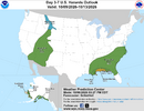
I would expect the CAD regions to receive widespread rainfall given the isentropic lift. Gusty winds seem certain with the pressure gradient, even well away from the center after landfall.the storm is going to disintegrate and explode/infuse moisture across the southeast
Depends how strong it gets before landfall. If 100mph is peak then landfall prob be a weak Cat 1. But if it's stronger then...NHC being bold with that cat 2 LF. Hmmm.
Edit: actually they note in discussion it should weaken from the 100mph peak before LF, but doesn't specify by how much.
The NHC hints at exactly this. There will be baroclinic forcing in play at and after landfall, too.
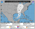
Tropical Depression Nine Discussion Number 1
NWS National Hurricane Center Miami FL AL092026
400 PM CDT Tue Oct 06 2026
Satellite imagery indicates that the area of low pressure located
over the southwestern Gulf of America has recently developed a
closed circulation, though it might still be elongated. Associated
showers and thunderstorms have also become better organized, and
this system now meets the criteria to be a tropical depression, the
ninth one of the season. The initial intensity is set at 30 kt based
on a Dvorak classification from TAFB.
The depression has barely moved over the past 6 to 12 hours, with
the initial motion estimated to be 120/1 kt. The cyclone is expected
to track slowly eastward or east-northeastward during the next
couple of days while it moves in the flow near the base of a broad
deep-layer trough, and could bring gusty winds and heavy rains to
the western portions of the Yucatan Peninsula on Thursday. By
Friday, a sharp turn to the northeast is expected when a shortwave
trough forms over Texas and a ridge strengthens over the western
Atlantic. This pattern change should cause the system to accelerate
toward the northern Gulf Coast on Friday and into early Saturday.
The NHC track forecast lies near the fast side of the guidance, in
best agreement with the GDMI and ECAI aids. It should be noted that
there is significant uncertainty in where the system makes the
northeast turn and how fast it moves toward the coast. It appears
that the stronger the system gets, the faster it will move toward
the coast given the strength of the deep-layer flow. The NOAA G-IV
jet is currently sampling the environment and special upper-air
soundings are being deployed over the south-central U.S. The
assimilation of these data into the dynamical models should improve
their representation of the current environmental conditions,
ideally yielding more reliable track and intensity guidance.
The environmental conditions appear generally conducive for
strengthening over the next few days, and given that the storm
appears compact, it will likely steadily strengthen during that
time. The NHC intensity forecast shows the system becoming a
tropical storm by early Wednesday and a hurricane on Thursday. Based
on the environmental conditions and the model guidance, the cyclone
will likely peak in strength before reaching the coast. Although not
seen in the forecast, some weakening seems likely when the storm
nears the Gulf Coast due to an increase in vertical wind shear, but
it is still expected to be a dangerous hurricane when it makes
landfall. This forecast is in fair agreement with the consensus
aids, but it should be noted that there are skillful models that are
higher than the current forecast.
Although the storm is expected to be compact for the next few days,
it will likely grow significantly in size, particularly on the
eastern side, when it reaches the northern Gulf Coast. Therefore,
based on the forecast uncertainty and expected larger size, users
are urged not to focus on the forecast points and stay tuned to
updates.
Key Messages:
1. There is an increasing risk of dangerous wind and storm surge
impacts along portions of the northern Gulf Coast, and watches could
be required on Wednesday. Residents from Louisiana to the Florida
Panhandle should closely monitor the latest forecast updates and
ensure they have their hurricane plan in place.
2. The system will bring areas of heavy rainfall to the central
U.S. Gulf coast Friday into the weekend. Flash and urban flooding,
along with isolated river flooding, will be possible.
3. Yucatan Peninsula of Mexico: The depression is expected to
strengthen and could bring gusty winds and areas of heavy rain to
the western portion of the Yucatan Peninsula in a couple of days.
FORECAST POSITIONS AND MAX WINDS
INIT 06/2100Z 22.1N 95.6W 30 KT 35 MPH
12H 07/0600Z 22.1N 95.0W 35 KT 40 MPH
24H 07/1800Z 22.6N 93.4W 45 KT 50 MPH
36H 08/0600Z 23.1N 91.8W 55 KT 65 MPH
48H 08/1800Z 24.2N 90.1W 70 KT 80 MPH
60H 09/0600Z 25.9N 88.8W 80 KT 90 MPH
72H 09/1800Z 28.5N 88.3W 85 KT 100 MPH
96H 10/1800Z 34.0N 88.7W 30 KT 35 MPH...INLAND
120H 11/1800Z 38.9N 86.5W 20 KT 25 MPH...POST-TROP/INLAND
$$
Forecaster Cangialosi