Z
-
Hello, please take a minute to check out our awesome content, contributed by the wonderful members of our community. We hope you'll add your own thoughts and opinions by making a free account!
You are using an out of date browser. It may not display this or other websites correctly.
You should upgrade or use an alternative browser.
You should upgrade or use an alternative browser.
Severe Weather November 29th
- Thread starter NWMSGuy
- Start date
NWMSGuy
Member
Anyone think we will see some PDS TOR watches issued tomorrow?
Z
Zander98al
Guest
I think so, I'm going to go in work early so I can get off early to be able to watch things unfold in Mississippi. It'll be a long day for the south.Anyone think we will see some PDS TOR watches issued tomorrow?
NWMSGuy
Member
Interesting statement from MEG in red:
Area Forecast Discussion
National Weather Service Memphis TN
337 PM CST Mon Nov 28 2022
...New DISCUSSION...
.DISCUSSION...
(This evening through next Sunday)
Issued at 336 PM CST Mon Nov 28 2022
A potential high-end severe weather event remains on track to
impact the Midsouth on Tuesday and Tuesday night. Tornadoes, a
few strong and long-lived, will be possible.
Low level moisture and instability will surge north through the
lower MS River valley Tuesday morning, in advance of a deepening
upper level longwave trof over the Great Plains. Initial round of
late morning/early afternoon storms will likely root in an elevated
layer, associated with a 925mb warm front surging north from the
Arklamiss. These storms will likely present a marginal severe
threat in the early afternoon, with midlevel lapse rates of 6.5
C/km accompanying MUCAPE below 300 J/KG.
The potential for storms to become rooted in a near-surface layer
will increase mid to late afternoon, aided by modest surface
heating and dewpoints rapidly warming into the mid/upper 60s.
During this period, convection-allowing model (CAM) consensus
depicts 850mb wind increasing from 40 to 60 KTs, elongating
hodographs and increasing 0-3km helicity to values in excess of
500 m2/s2.
Uncertainty remains regarding the extent and timing of low level
inversion erosion in the absence of strong surface heating. This
will largely determine the northward extent of the tornado threat
in the late afternoon, prior to steep midlevel height falls.
While some uncertainty remains regarding the onset timing of
surface-based convection and associated tornado threat, the
parameter space will become quite concerning by early Tuesday
evening, aided by CAPE in excess of 1000 J/kg and steep height
falls and strongly bowed hodographs. Low LCLs (cloud bases) and
storm movement in excess of 60 mph will make for particularly
dangerous convective environment, where tornadic storms appear to
arrive suddenly, preceded by little if any visual or audible
notice. Definitely a time to keep a weather radio with battery
backup and a fully-charged cell phone nearby.
Beyond Tuesday`s severe event, generally quiet weather is
forecast from through the upcoming weekend, under fast zonal flow
aloft. A northern branch upper low will pass through the Great
Lakes on on Saturday, modestly depressing midlevel heights over
the Midsouth and aiding the passage of a Pacific cold front. A few
showers will accompany the frontal passage, with only limited
chances for thunder.
PWB
Darklordsuperstorm
Member
I'm anticipating that we haven't seen the end of the eastward shift with the risk area. It may be a game of catch up right up until kickoff of the event. IMO Enhanced risk all the way I-65 not out of the question.
Z
Zander98al
Guest
Tornado outbreak likely per the NWS
WxMan42711
Member
I'm anticipating that we haven't seen the end of the eastward shift with the risk area. It may be a game of catch up right up until kickoff of the event. IMO Enhanced risk all the way I-65 not out of the question.
this area will be one to watch. east ms/west al are going to be on the tail end of any potential long-track supercells that develop to their west.

Last edited:
NBAcentel
Member
Do think there’s gonna possibly be a few strong/violent tornadoes tomorrow, but tomorrow has reasons why it might go wrong, 1st off being the lack of synoptic scale lift/forcing seen on vorticity maps and more WAA then modeled leading to lots of ELEVATED convection, but that could lay a boundary down for storms tomorrow night, a pretty formidable event seems pretty likely still
Z
Zander98al
Guest
That's my thoughts too, lol tornadocast put southern Mississippi on alert but the NWS has northern Mississippi. All of Mississippi will probably have it's chance at a tornadic storm at some point in the day. Worried about the finer mesoscale details of the day, which could really escalate things.
Jackson Mississippi would be right around where I would set up shop if I were to chase, decent mesh point
Itryatgolf
Member
When does the hrrr come out again? 0zThat's my thoughts too, lol tornadocast put southern Mississippi on alert but the NWS has northern Mississippi. All of Mississippi will probably have it's chance at a tornadic storm at some point in the day. Worried about the finer mesoscale details of the day, which could really escalate things.
Jackson Mississippi would be right around where I would set up shop if I were to chase, decent mesh point
Z
Zander98al
Guest
Right now, it'll take a bit for it to finish it's on hour 3 currentlyWhen does the hrrr come out again? 0z
Itryatgolf
Member
It looked kinda interesting for my area last run. Hopefully it holds up.Right now, it'll take a bit for it to finish it's on hour 3 currently
Snowman63
Member
It looked kinda interesting for my area last run. Hopefully it holds up.
You want severe weather in your area?It looked kinda interesting for my area last run. Hopefully it holds up.
You want severe weather in your area?It looked kinda interesting for my area last run. Hopefully it holds up.
Itryatgolf
Member
I like to go on some chases so yes to your question.You want severe weather in your area?
You want severe weather in your area?
NWMSGuy
Member
Maybe it's just me but the 0Z HRRR doesn't look as excited as the 18Z?
WxMan42711
Member
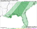
this area will be one to watch. east ms/west al are going to be on the tail end of any potential long-track supercells that develop to their west.
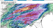
View attachment 124229

The threat does shift east for Wednesday and here in Georgia SPC has us under a marginal risks for severe storms and excessive rainfall. This should be diminished compared to areas further west due to the timing of the front, which looks to pass here early Wednesday morning. Without access to daytime heating, this will limit the potential for instability here, as CAPE values will max out around 500J/kg.Think this would shift east for Wednesday or is this a Tuesday only threat for areas shaded?
Attachments

Z
Zander98al
Guest
?
Z
Zander98al
Guest
Central and southern central Mississippi is going to rocking later today, my guess on heaviest activity is there
Darklordsuperstorm
Member
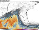
Going to be interesting to watch the northern extend of the warm sector today. These are current dewpoint. 
Z
Zander98al
Guest
Is there wildfires or something in Alabama, all across Jefferson county I've smelled smoke and haze. Must be haarp messing with the weather for the incoming possibility of severe weather. JUST KIDDING of course lol. If it's widespread smoke from west of here then that might through a kink in forecasting lol
Z
Zander98al
Guest
KellynaMoon
Member
I’ve been watching this group for ages but have never posted anything. Just made an account to reply to @Zander98al agreeing that it seems any storms in the south veer into Alabama. Especially Tuscaloosa (it feels like, but you have to admit this place is a magnet).
Anyways that’s my first post. Sorry it wasn’t more entertaining.
Anyways that’s my first post. Sorry it wasn’t more entertaining.
Bama Ravens
Member
It was 32.7 degrees where I live about 20 miles north of Birmingham this morning. It doesn't "feel" like a severe weather threat exists over the next 20 hours. I know it doesn't take much unstable air in the winter season to get severe weather, but it seems like central Alabama (particularly north of I-20/59) will have to see a major airmass change for things to get going there. I know there is still plenty of time for an airmass change, but it does make me wonder if it will actually happen for my area.
Z
Zander98al
Guest
I'm begging to think it's going to be a very sharp gradient on significant severe to just some thunder. The more closer the event comes the. More I think that northwest section of MS is going to miss. And more of southwest Alabama and west Alabama are going to hit. Just a hunch but who knows. HRRR tends to agree a bit.
Z
Zander98al
Guest
FWIW
- Joined
- Jan 5, 2017
- Messages
- 3,769
- Reaction score
- 5,966
It does appear current dewpoints are running 10 degrees below where the HRRR puts them on the 14z run at this time. Could the lower atmosphere recover? I'd say we will know by 12 pm central. HRRR looks like more of a western central AL and eastern central MS hit, just as SPC has outlined it. CAD seems to hold long enough to stabilize everything around Birmingham and east.It was 32.7 degrees where I live about 20 miles north of Birmingham this morning. It doesn't "feel" like a severe weather threat exists over the next 20 hours. I know it doesn't take much unstable air in the winter season to get severe weather, but it seems like central Alabama (particularly north of I-20/59) will have to see a major airmass change for things to get going there. I know there is still plenty of time for an airmass change, but it does make me wonder if it will actually happen for my area.
- Joined
- Jan 5, 2017
- Messages
- 3,769
- Reaction score
- 5,966
Wildfires galore in GA. East wind blew the smoke into AL. Shows you where the CAD is.Is there wildfires or something in Alabama, all across Jefferson county I've smelled smoke and haze. Must be haarp messing with the weather for the incoming possibility of severe weather. JUST KIDDING of course lol. If it's widespread smoke from west of here then that might through a kink in forecasting lol
- Joined
- Jan 5, 2017
- Messages
- 3,769
- Reaction score
- 5,966
LukeBarrette
im north of 90% of people on here so yeah
Meteorology Student
Member
2024 Supporter
2017-2023 Supporter
Thats my tweet haha
Z
Zander98al
Guest
Lol I recognized the nameThats my tweet haha
NWMSGuy
Member
Lots of convection currently moving through this area. Makes me wonder also if there is room for any type atmospheric recovery for later.I'm begging to think it's going to be a very sharp gradient on significant severe to just some thunder. The more closer the event comes the. More I think that northwest section of MS is going to miss. And more of southwest Alabama and west Alabama are going to hit. Just a hunch but who knows. HRRR tends to agree a bit.
Z
Zander98al
Guest
Doubt it, seen it so many times with models over forecasting recovery lol. Main threat will be southeast of the current blob of convection right now I'd assume. As well as a shift of higher propebailities east and southeastwardLots of convection currently moving through this area. Makes me wonder also if there is room for any type atmospheric recovery for later.
Z
Zander98al
Guest
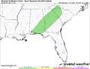
The hatched area is where I think the most devasting storms will turn up. This is my hot take area as of now. Lol
Probably. Always seems to be the case when moisture return is in question, along with it being southern MS.The hatched area is where I think the most devasting storms will turn up. This is my hot take area as of now. LolView attachment 124265
lj0109
Member
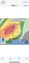
New SPC Update:

Day 1 Convective Outlook
NWS Storm Prediction Center Norman OK
1021 AM CST Tue Nov 29 2022
Valid 291630Z - 301200Z
...THERE IS A MODERATE RISK OF SEVERE THUNDERSTORMS THIS AFTERNOON
AND TONIGHT OVER PARTS OF NORTHEAST LOUISIANA...EXTREME SOUTHEAST
ARKANSAS...CENTRAL AND NORTHERN MISSISSIPPI...AND NORTHWEST
ALABAMA...
...SUMMARY...
Strong tornadoes, very large hail, and severe wind gusts are
forecast this afternoon into the overnight period across parts of
the lower to mid Mississippi Valley, Mid-South and parts of the
Southeast.
...Regional Outbreak of severe thunderstorms and tornadoes is
forecast today and tonight for parts of the lower Mississippi
Valley...
...Lower MS Valley...
Morning water vapor imagery shows a broad upper trough over much of
the CONUS this morning, with several fast moving shortwave troughs
moving across the southwest into the southern Plains. Strong
southerly low-level winds have developed across the lower MS Valley,
aiding in the rapid return of rich Gulf moisture. Dewpoints in the
mid/upper 60s have spread into much of east TX and LA, and should
extend into central MS by mid-afternoon. Plentiful low clouds are
present, limiting daytime heating. But relatively steep mid-level
lapse rates and returning moisture will lead to widespread MLCAPE
values of 1000-1500 J/kg later today, with only a weak cap.
Vertical shear profiles are very strong throughout the region, with
effective SRH values of 200-400 m2/s2 beneath 50+ knots of
deep-layer shear. Given the subtle forcing today, relatively
long-lived discrete supercell storms are expected with an attendant
threat of intense and long-track tornadoes.
Present indications are that primary thunderstorm development will
begin early this afternoon over parts of LA, spreading quickly into
MS. This corridor may see multiple waves of severe convection as
storms redevelop upstream through the evening. Along with the
strong tornado threat, very large hail and damaging wind gusts may
occur with these storms. Consideration was made to introduce a
small HIGH risk, but still too much uncertainty in the exact
corridor of highest risk since moisture is not yet in place and
there is no surface boundary to focus on.
..Hart/Wendt.. 11/29/2022
Z
Zander98al
Guest
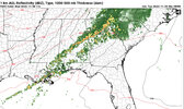
Current observations.
* Dew points are rising quickly in western Alabama along with temps..gif")
.gif")
.gif")
* Dew points are rising quickly in western Alabama along with temps.
Darklordsuperstorm
Member
Moisture recovery seems to be going strong so far. Already feels completely different than it did this morning.