NWMSGuy
Member

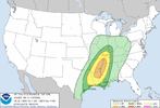
Spc also mentions a possible upgrade in later forecast
I’m just outside the red area, hope it stays that way.?
Is there a chance south Alabama could get in on this action?Spc also mentions a possible upgrade in later forecast
wow...that spells big trouble. strong tornadoes soundings to perhaps even violent typeNAM spitting out PDS Soundings over Northwest MS. ?
View attachment 124161
Wouldn't be surprised to see a Moderate Risk issued in the Day 2 outlook, overnight.wow...that spells big trouble. strong tornadoes soundings to perhaps even violent type
if the instability can hold together for one, but the main surface low races further northeast... wouldnt sleep on it yetIs there a chance south Alabama could get in on this action?
Will be interesting to see how this plays out. Have been trying to keep up with the conversation regarding this event on Twitter. Would be great to see some more detailed opinions on here as well. Do we see more a high end event unfold or does this have bust potential written all over it?MEG is now saying a tornado ? outbreak possible shaping up late Tuesday in to the night . Strong tornadoes likely . Folks that pretty agressive forecast from a usually conservative forecaster for meg
Meg is question some instability , but even latest guidance has slowly increased that far north as my tn state line … pushing 1200 cape values … remember this is also considered cool season setup. Won’t take a high end instability of cape . Low lever shear is off charts with increasing overhead jetWill be interesting to see how this plays out. Have been trying to keep up with the conversation regarding this event on Twitter. Would be great to see some more detailed opinions on here as well. Do we see more a high end event unfold or does this have bust potential written all over it?
True. Even considering the past couple years with some of these storms, the wind damage alone has been problematic enough.Meg is question some instability , but even latest guidance has slowly increased that far north as my tn state line … pushing 1200 cape values … remember this is also considered cool season setup. Won’t take a high end instability of cape . Low lever shear is off charts with increasing overhead jet
Moderate risk next update… I predictWell this is concerning ?.

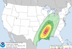
Expanded moderate outlook covering most of north MS.
I was hoping to stay out of the worse of it but it keeps creeping.Atleast for my county I’m hoping that’s a positive sign that it hasn’t expanded more on the west side. Waiting to see what the 18Z HRRR shows.
Hit or miss, it's done spectacular for some events aka the Carolina outbreak what last year or this past spring and then it's failed miserably on other events. More so a interesting thing to see where the best parameters may setup imo. Seems this model thinks south MS will be the hotzone.Anyone know anything about this model? Please take this with a grain of salt doesn’t look right but was wondering if it has any respect by any Mets.
