• Hello, please take a minute to check out our awesome content, contributed by the wonderful members of our community. We hope you'll add your own thoughts and opinions by making a free account!

Severe Severe Thread May 4-6

Speed shear is pretty meager across Alabama. Directional is fantastic, with really good placement of 500mb trough and westerly winds.

Could be a pretty active day southeast of that day 4 , 30% area. A decent adjustment will probably be made in the coming days.

Some big hail will be a issue along with wind damage though.
 
Last edited by a moderator:
Not gonna lie, the NAM is pretty impressive across the SE and the GFS is close.
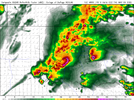
Perfect 500mb position. If the the WRF signals something then I'm going to get on board this ship. Just when we get into may we really start to lack the dynamics.

Edit; just checked the newest model suite of the NAM heck Alabama is looking good. Still going to wait a bit. Stacked lows as well.
 
OKC might double the year to date rainfall total in the first 5 days of May. Had only about 6 inches up to May 1st. Since then have had over 2 inches yesterday and could get another 2-4 inches with this system. Much needed given how dry late last year and this year has been up to this week.
 
OKC might double the year to date rainfall total in the first 5 days of May. Had only about 6 inches up to May 1st. Since then have had over 2 inches yesterday and could get another 2-4 inches with this system. Much needed given how dry late last year and this year has been up to this week.
1651608342079.png
 
New Day 1 has the highest tornado probabilities just to my south. They do mention major uncertainty on how far north the warm front gets. I'm still much more concerned about the flood threat locally but it will be interesting to see if some sneaky cells can get close spccoday1.tornado.latest (3).png
 
I think best chance of any tornado activity today is going to be just south of the warm front if any warm sector supercells develop. HRRR from time to time has been showing supercell development in close proximity to the warm front which could enhance tornado potential. Aside from that most everything else looks messy today.119BB545-D186-4985-BFED-7813CBE0D15D.png
 
This is getting hard to ignore. The nam 12km/3km differ in speed but have high end parameters. the HRW looks like a blend between the 2 with supercells along the warm front and then along the front, with otherwise multicellular stuff along the CF. Where that triple point like stuff sets up is still a question. Lots of Sfc backing with very very large instability and drying aloft in it.ED35BE6B-2FB5-4576-9E6C-7E3ABE55AECD.png1ABEA1A5-12E6-4D43-AD28-26CB3363509E.png
 
This is getting hard to ignore. The nam 12km/3km differ in speed but have high end parameters. the HRW looks like a blend between the 2 with supercells along the warm front and then along the front, with otherwise multicellular stuff along the CF. Where that triple point like stuff sets up is still a question. Lots of Sfc backing with very very large instability and drying aloft in it.View attachment 118032View attachment 118033
FV3 Is i about 12 hours faster than the nam 3km which puts a kink in forecasting. Either way if it's faster looks more of a Georgia eastward event slower a more Mississippi and Alabama. Probably will be a bit of a blend. WRF is right on the cusp and looks to be a bit slower.

Very good dnyamics in a climatology of usually high instability, usually these lows travel more north than this. WRF almost has a sub 100mb low.
 
Back
Top