Before I go to bed I will write Inland areas in North Carolina are west of the coast fifty times.
-
Hello, please take a minute to check out our awesome content, contributed by the wonderful members of our community. We hope you'll add your own thoughts and opinions by making a free account!
You are using an out of date browser. It may not display this or other websites correctly.
You should upgrade or use an alternative browser.
You should upgrade or use an alternative browser.
Pattern Oct 10-13 Nor Easter or No Easter
- Thread starter SD
- Start date
Shaggy
Member
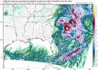
Hi res still coming in aggressive with wind and heavier rains.. starting to flirt with some double digit totals not far offshore
Shaggy
Member
Yeah those wind maps are always overdone. I do think the winds along the coast will be higher than what yhe globals had been showing. The hi res are really cranking this low upNAM bringing 50mph winds inland (not gonna happen), HRRR with 40, still overdone I'm sure. But next couple days definitely look breezy with 30 mph gust maybe. @Shaggy you might get some gales down your way, enjoy
GeorgiaGirl
Member
Won’t last, but I am picking up rain from this nor’easter…thing this morning.
Shaggy
Member
First rain Guage check had .80 exactly in it. The 3k is super aggressive with both winds and rain totals. I know we are suppose to trust hinres in this time frame but it just seems too aggressive to me. It would have me into double digit rainfall totals.
This is really interesting. The low almost has some tropical characteristics to it tonight into tomorrow before it stacks and the mid levels cool. If we can avoid the secondary low taking over towards the mid Atlantic this should be a big rain event for central and Eastern carolinas.
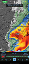
What app is thisanyone buying 12z NAM? NWS GSP mentions having to bump totals in central and eastern carolina.View attachment 175460
@SD it's WeatherFront. Great app. Just wish it had ECMWF rainfall totals.What app is
Shaggy
Member
Already closing in on an inch here. Winds stiffening a bit but still only in the teens gusting into the 20s.
Looks like it's apple only. Sad@SD it's WeatherFront. Great app. Just wish it had ECMWF rainfall totals.
Shaggy
Member
Hate to get sucked in by the hi res wind profiles but it looks like 4pm through midnight is the best chance to see some wind for mby. Trying to decide if I want to go over to the east beaches or southern beaches this afternoon
Last edited:
Shaggy
Member
Sounds like there's quite a bit of street flooding from the high tides over in Wrightsville and carolina beaches. Probably means I skip the trip over there
Avalanche
Member
Heading to Wrightsville around 5. Will report backSounds like there's quite a bit of street flooding from the high tides over in Wrightsville and carolina beaches. Probably means I skip the trip over there
Shaggy
Member
There's a NDBC station on Johnnie Mercer pier and it's only gusting to 22kts so a big nothingburger so farHeading to Wrightsville around 5. Will report back
Shaggy
Member
I mean it's still not strong but the winds have definitely stiffened up in the last 30 minutes or so probably into the 20s maybe Gustin 30 to 35 so there might be a little bit of something at the beach
Not too much happening in the Monkey Junction area wind wise just under 20 mph sustained gusting to 30ish by my estimate
Last edited:
This system is moving at a crawl. I've been waiting all afternoon for the precipitation to start at my house in Wake County and I am still waiting. Since this system seems to be in no hurry maybe rainfall amounts will be higher than projected. Any amount of rain would be welcome at this point considering the dry spell that most of North Carolina has been in.
Shaggy
Member
Johnnie Mercer gusting to 37kts
Shaggy
Member
The low clouds are scooting like its a TC outside. Velocities overhead are in the 50sWinds have really picked up here since it started getting dark ~45 minutes ago. Sky has that roaring sound to it now.
Shaggy
Member
Probably a good storm 500 feet up
Sorry folks had too travel too Durham this Morning/Afternoon, as I was exiting Raleigh, it started to sprinkle.. Got worse coming down I-40.. nasty..
Home here in Topsail Now, winds STEADY, NE @ 20 plenty rain, (Over a inch)..
Home here in Topsail Now, winds STEADY, NE @ 20 plenty rain, (Over a inch)..
LOCAL NWS write up..
Low pressure that will eventually blossom into becoming a nor`easter
is still slowly developing, now east of Savannah. Last night`s
guidance has shifted stronger and a tad closer to the coast. The
main ramifications to the forecast has been slightly higher winds
along the coast and higher QPF for inland locales. The upper trough
that is driving the system is still digging, and this appears to
giving guidance a hard time resolving whether the current incipient
low remains dominant or a secondary forms on the system`s warm
front. Locally this won`t matter too much, but the overall
progression looks a little slow even in solutions lacking a
secondary low.
So basically even as this system is starting to get going their are still question marks and the overall progression of the system is perhaps slower than originally thought. Sounds like a nowcast type forecast for who gets whatLOCAL NWS write up..
Low pressure that will eventually blossom into becoming a nor`easter
is still slowly developing, now east of Savannah. Last night`s
guidance has shifted stronger and a tad closer to the coast. The
main ramifications to the forecast has been slightly higher winds
along the coast and higher QPF for inland locales. The upper trough
that is driving the system is still digging, and this appears to
giving guidance a hard time resolving whether the current incipient
low remains dominant or a secondary forms on the system`s warm
front. Locally this won`t matter too much, but the overall
progression looks a little slow even in solutions lacking a
secondary low.
Sent from my SM-S156V using Tapatalk
Poof gone
Shaggy
Member
Wind really started cranking a couple hours ago. Been waking me up from time to time when it hits the house
If u look at Storm Total Accumulation on Radarscope or Weatherwise the rainfall cutoff line for my location u can definitely tell. Cutoff was close to the I-85 corridor. East of 85 u got measurable rain west of 85 close to 0. But what gets me is what happened here did enough dry air punch into this system?Poof gone
Sent from my A600DL using Tapatalk
Last edited:
Stormsfury
Member
Overperforming in the Eastern/Central portions of the Lowcountry. Have picked up a couple inches of rain overnight, heavy rain continuing, and breezy to windy conditions continuing. The attendant SFC Low is barely moving with the large upper still digging its heels. I noticed KILM has really upped their rainfall amounts across the Pee Dee Region early this morning and there was a large anchored band of heavy rain over Georgetown County that dropped 3 to 6 inches of rain overnight.
I wasn't expecting anything. Not much of a cut off it just disappeared lolIf u look at Storm Total Accumulation on Radarscope or Weatherwise the rainfall cutoff line for my location u can definitely tell. Cutoff was close to the I-85 corridor. East of 85 u got measurable rain west of 85 close to 0. But what gets me is what happened here did enough dry air punch into this system?
Sent from my A600DL using Tapatalk
Shaggy
Member
Rains been spotty and light this morning but frequent gusts into upper 30s and even into the mid 40s at its peak for ILMOverperforming in the Eastern/Central portions of the Lowcountry. Have picked up a couple inches of rain overnight, heavy rain continuing, and breezy to windy conditions continuing. The attendant SFC Low is barely moving with the large upper still digging its heels. I noticed KILM has really upped their rainfall amounts across the Pee Dee Region early this morning and there was a large anchored band of heavy rain over Georgetown County that dropped 3 to 6 inches of rain overnight.
Stormsfury
Member
GeorgiaGirl
Member
Still picking up rain from this system today and it looks as if I'll be getting more through the day as the Euro/NAM suggesting that the southern side of this would be able to be featured a little was correct.
Can even see a little swirl off the SE coast on the satellite loop.
Can even see a little swirl off the SE coast on the satellite loop.
Avalanche
Member
I parked at the pier but it was pretty much non eventful. Seas a tad rough but I’ve swam in worse on a sunny day.There's a NDBC station on Johnnie Mercer pier and it's only gusting to 22kts so a big nothingburger so far
.64 basically doubling my 60 day rain total
Shaggy
Member
Yeah it definitely picked up overnight but yesterday was fairly tame. Had one good gust hit the house sometime this morning that woke me up.I parked at the pier but it was pretty much non eventful. Seas a tad rough but I’ve swam in worse on a sunny day.
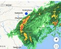
Gotta watch that big blob of heavy rain to see if it tries to pivot its way up here or if it rains itself out over the SC coast


