• Hello, please take a minute to check out our awesome content, contributed by the wonderful members of our community. We hope you'll add your own thoughts and opinions by making a free account!

Pattern May-hem

This month is going to be slight above almost for sure, but honestly the last two weeks of this month...is basically early summer like weather anyway where high 80s low 90s with humidity is normal. That break from it with the rain last week was wonderful.
 
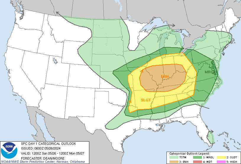
We have a slight risk up here in North Georgia through Upper South Carolina and lower North Carolina today. Wonder which model will win this time. I put money on the HRRR as it has been better than the NAM lately.
day1otlk_1200.gif
 
Jumpin June Flash.

I was born in a cross-fire hurricane
And I howled at the morning driving rain
But it's all right now, in fact, it's a gas
But it's all right. I'm Jumpin' Jack Flash
It's a gas, gas, gas
I was raised by a toothless, bearded hag,
I was schooled with a strap right across my back
But it's all right now, in fact, it's a gas
But it's all right, I'm Jumpin' Jack Flash
It's a gas, gas, gas
I was drowned, I was washed up and left for dead
I fell down to my feet and I saw they bled , yeah yeah
I frowned at the crumbs of a crust of bread
Yeah, yeah, yeah
I was crowned with a spike right through my head
But it's all right now, in fact, it's a gas
But it's all right, I'm Jumpin' Jack Flash
It's a gas, gas, gas
Jumping Jack Flash, its a gas
Songwriters: Keith Richards / Mick Jagger
 
Hrrr brings a nice area of storms through around dark I'm in

Sent from my SM-G928V using Tapatalk
I couldn't be more in the middle of the slight risk area! I am expecting nothing! GSP seemed very non impressed with today's storm chances yesterday afternoon
 
I couldn't be more in the middle of the slight risk area! I am expecting nothing! GSP seemed very non impressed with today's storm chances yesterday afternoon
Hrrr and both nams are all in on the slight risk area today. I expect fail

Sent from my SM-G928V using Tapatalk
 
Hmm I wonder if the complex over central AL can grow upscale. Definitely looks like a MCV forming on the back side.
 
If someone wants to start the june thread be my guess

Sent from my SM-G928V using Tapatalk
My guess is, no rain today! But maybe the ATL storms can find away to make it here or kick out some good outflow boundaries!
 
My guess is, no rain today! But maybe the ATL storms can find away to make it here or kick out some good outflow boundaries!
Disturbance just getting into NE Ga now we will see what the rest of the evening brings

Sent from my SM-G928V using Tapatalk
 
Disturbance just getting into NE Ga now we will see what the rest of the evening brings

Sent from my SM-G928V using Tapatalk
It's rolling right up 85, and some discretes trying to roll off the mountains! Could be a rainy evening
 
For May as a whole, it now looks practically certain that parts of SW GA into S AL, Anniston, Tuscaloosa, W TN, much if not all of AR, and most of MS will end up slightly cooler than normal. BHM will be close. The rest of the SE will be mainly slightly warmer than normal. The long warmer than normal streaks at ATL, SAV, and GNV continue!
 
It's rolling right up 85, and some discretes trying to roll off the mountains! Could be a rainy evening
Unless things change me and you will be lucky to get .10 out of this. A classic upstate SC split with the stronger storms.
 
I think this latest batch of rain is going to miss me. :mad:
I feel like I'm slowly baking, even when I'm in the house, so this isn't fun...
 
Lame ass storms! The STW kiss of death! No thunder and light rain. Weakened dramatically as the entered GSP area! :(
 
Lame ass storms! The STW kiss of death! No thunder and light rain. Weakened dramatically as the entered GSP area! :(
The 61-64 degree dewpoints hurt. The storms hit the drier air and dried up. Hopefully this does not signal how our summer will go, but I would not bet against it.
 
This storm near Columbia has a classic Flare Echo/Three Body Scatter Signature (TBSS) that's characterized as an elongated echo region orientated downstream from a (often strong) thunderstorm core that's a a result of very large hydrometeors (water-based particles, (typically hail)) and tends to occur in conjunction with large-very large hail and very destructive straight line winds in concomitant downdrafts. See Lemon (1998) for more information. I learn something new everyday! http://journals.ametsoc.org/doi/full/10.1175/1520-0434(1998)013<0327:TRTBSS>2.0.CO;2
 
This storm near Columbia has a classic Flare Echo/Three Body Scatter Signature (TBSS) that's characterized as an elongated echo region orientated downstream from a (often strong) thunderstorm core that's a a result of very large hydrometeors (water-based particles, (typically hail)) and tends to occur in conjunction with large-very large hail and very destructive straight line winds in concomitant downdrafts. See Lemon (1998) for more information. I learn something new everyday! http://journals.ametsoc.org/doi/full/10.1175/1520-0434(1998)013<0327:TRTBSS>2.0.CO;2
We do too!
 
Back
Top