Z
-
Hello, please take a minute to check out our awesome content, contributed by the wonderful members of our community. We hope you'll add your own thoughts and opinions by making a free account!
You are using an out of date browser. It may not display this or other websites correctly.
You should upgrade or use an alternative browser.
You should upgrade or use an alternative browser.
Z
Zander98al
Guest
Have not checked it too much but I think it's the typical QCLS embedded tornado with a few isolated supercells. Looks like instability its supple but shear is a bit lacking from a larger scale view.
Will check later, very busy week for me.
Will check later, very busy week for me.
Z
Zander98al
Guest
NOAA
weather.gov
National Weather Service National Headquarters
National Weather Service
Home Site Map News Organization Search for:
NWS All NOAA
Local forecast by
"City, St" or Zip Code
City, St
RSS Feeds RSS Feeds
Area Forecast Discussion
Issued by NWS Birmingham, AL
Current Version | Previous Version | Text Only | Print | Product List | Glossary Off
Versions: 1 2 3 4 5 6 7 8 9 10 11 12 13 14 15 16 17 18 19 20 21 22 23 24 25 26 27 28 29 30 31 32 33 34 35 36 37 38 39 40 41 42 43 44 45 46 47
000
FXUS64 KBMX 041657
AFDBMX
Area Forecast Discussion
National Weather Service Birmingham AL
1057 AM CST Fri Mar 4 2022
.UPDATE...
Midday Update and 18Z Aviation.
&&
.SHORT TERM...
/Updated at 1054 AM CST Fri Mar 04 2022/
Through Tomorrow.
Subtropical ridging remains centered over the Southeast with sfc
high pressure over the Northeast region. Southerly low-level flow
transitions to westerly aloft which continues to support above
average temperatures with slight height rises today as the ridge
amplifies. Overall, the airmass is dry and stable, but there will be
an increase in low-level moisture tomorrow as the ridge continues to
shift further east. This should provide more low-level clouds, in
addition to cirrus which will move in from the northwest this
afternoon, but there will be an abundance of sunshine
nonetheless. Temperatures will reach the upper 70s to lower 80s
both today and tomorrow.
86
.LONG TERM...
/Updated at 0320 AM CST Fri Mar 04 2022/
Saturday night through Monday night:
A shortwave trough and associated surface low will lift
northeastward across the Upper Midwest and Great Lakes Saturday
night, while an anomalous 590 decameter subtropical ridge remains
centered near the Florida Keys. Southerly winds will result in
milder low temperatures in West Alabama, while East Alabama will
remain closer to the surface high and have continued favorable
radiational cooling conditions. Southerly winds will result in
another unseasonably warm day Sunday, though as dew points begin to
increase there will be some cumulus clouds developing with daytime
heating. There could be just enough moisture for an isolated shower
to develop in far West Alabama with daytime heating. NBM 50th
percentile high temperatures are right at daily record high values,
and will stick with these for now given the uptick in moisture, but
these may need to be increased with later updates. A surface low
tracking from the Ozarks to the Ohio Valley Sunday night will result
in continued southerly winds and mild low temperatures. Low-level
moist isentropic lift may be sufficient for a few showers in West
Alabama late Sunday night as well.
Another shortwave ejects out of the mean western CONUS trough and
lifts northeastward across the Ozarks Monday. It will be shearing
out/deamplifying as it interacts with a northern stream trough, but
still be accompanied by a strong mid-level speed max on its
southeastern flank. While the vort max itself tracks well northwest
of Central Alabama, it still produces modest height falls across
Central Alabama. PWATs increase to around 1.5 to 1.6 inches along a
strong cold front that approaches the area. Taking into effect model
cool biases at the surface, CAPE values increase to around 1000 to
1500 J/kg with decent lapse rates associated with a remnant elevated
mixed layer (EML). Westerly 0-6km bulk shear values around 50 kts
would be favorable for supercells with the potential for
hail/damaging winds at minimum. Tornado threat is a bit less clear,
as the main surface low will be northeast of the area, but some
guidance does indicate a potential secondary surface low/secondary
LLJ max developing with sufficient SRH for a couple tornadoes.
Breezy conditions will be possible as well. Will add in a mention
of all modes of severe weather to the HWO for Monday afternoon
and evening, with the relatively highest threat along and north of
I-20.
Tuesday through Thursday:
Overall western trough/southeast ridge pattern remains in place next
week, with another shortwave ejecting across the south-central CONUS
by the middle of next week and southwest flow aloft continuing
across Central Alabama. The front will stall from the northern Gulf
to southeast Georgia, and the shortwave will cause a wave of low
pressure to develop along it. There is some model spread regarding
the exact location of the front and the track of the surface low,
but in general expect another round of widespread rain during the
midweek period. If the further north solutions come true, will have
to monitor instability trends over the southeast counties Wednesday
as well as rainfall amounts, but overall expect the best instability
to be southeast of the area. PoPs will likely need to be
raised/lowered for some periods when model consistency improves, and
high temperatures may need to be lowered on one or more days.
32/Davis
&&
.AVIATION...
18Z TAF Discussion.
Stable and dry across the area through this TAF period with
subtropical ridging over the Southeastern region. Mostly sunny skies
today with cirrus entering from the northwest. Guidance continues to
indicate low-level ceilings will develop near TOI and MGM ~12Z, but
ceilings should remain ~5kft and higher. Otherwise, sfc winds will
be easterly to southeasterly around 5 to 8 kts and variable
overnight.
86
&&
.FIRE WEATHER...
Fair weather is forecast over the next several days. Minimum
afternoon RH values today will be in the upper teens to mid 20s
across the area. 20-foot winds will become south-southeasterly by
this afternoon and continuing for Saturday with an increase in
speed by midday Saturday. Moisture begins to increase over the
weekend with minimum RH values mainly in the 30 to 40 percent
range. Rain chances return on Monday.
&&
.PRELIMINARY POINT TEMPS/POPS...
Gadsden 79 48 79 52 81 / 0 0 0 0 10
Anniston 79 51 79 53 83 / 0 0 0 0 10
Birmingham 80 52 80 56 82 / 0 0 0 0 10
Tuscaloosa 81 50 81 57 83 / 0 0 0 0 10
Calera 80 52 81 54 82 / 0 0 0 0 10
Auburn 79 53 79 53 82 / 0 0 0 0 0
Montgomery 82 50 83 53 85 / 0 0 0 0 10
Troy 83 50 83 55 87 / 0 0 0 0 0
&&
.BMX WATCHES/WARNINGS/ADVISORIES/...
None.
&&
$$
USA.gov is the U.S. government's official web portal to all federal, state and local government web resources and services.
National Weather Service
National Weather Service National Headquarters
1325 East West Highway
Silver Spring, MD 20910
Incorrect Region Format!
Web Master's E-mail: NWS Internet Services Team
Page last modified: Nov 18th, 2021 21:12 UTC
Disclaimer
Credits
Glossary
Privacy Policy
About Us
Career Opportunities
Darklordsuperstorm
Member
Gonna depend a lot on where that surface low is. Haven't had an opportunity to look today but yesterday it was showing up in west Virginia and Pennsylvania area. Definitely less than ideal however cape will definitely not be an issue.
Z
Zander98al
Guest
Birmingham mentions a secondary surface low developing north of northwest of Alabama I think,. Looked at just The nam quickly so I'm not sure. Would help with shear, and better placement for directional shear. As usually with a way ahead surface low racing Northeastward and a cold front slowly dragging every thing is just linear. You'll probably see instability rise like usual. Should be sampled very soon if not already so a few adjustments may come.Gonna depend a lot on where that surface low is. Haven't had an opportunity to look today but yesterday it was showing up in west Virginia and Pennsylvania area. Definitely less than ideal however cape will definitely not be an issue.
Z
Zander98al
Guest
Sounding for Birmingham at peak parameters time for our area. Paramters aren't half bad. 3cape above 150. Lapse rates all above pretty much 6.5 with 7+ surface to 3km. SRH Helicity is meh. But it'll probably be locally higher when we get closer into the CAMS. along with Thermodynamics increasing. Probably the best Thermodynamics for a a event in our area this year so far. Will have to keep a close eye as we creep closer. 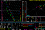

Z
Zander98al
Guest
18z nam is trying to fire pre frontal convection mid morning early afternoon around central Alabama. If this system slowed down the shear and Thermodynamics would mesh pretty good. Shear has increased from the 12z to 18z.
Z
Zander98al
Guest
Z
Zander98al
Guest
Wouldn't be surprised to see this turn into just a marginal threat. Looks like absolute poopy now haha
HSVweather
Member
Iowa right now…
HSVweather
Member
HSVweather
Member
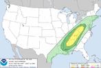
BMX LATEST GRAPHIC FOR MONDAY
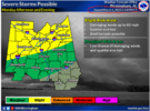
.LONG TERM...
/Updated at 0240 PM CST Sat Mar 05 2022/
Severe weather forecast remains on track this afternoon, and
model trends continue to agree with previous forecast thinking.
Will continue to highlight potential for severe storms and
tornadoes mainly north of I-20, Monday afternoon and evening.
Beyond Monday night, forecast models continue to show the front
stalling, with a large swath of rainfall overrunning the front
Tuesday night and Wednesday, as a surface low develops in the
northwestern Gulf of Mexico. It`s possible the moist pattern
remains through the week, with southwesterly mid level flow and
another cold front on Friday.
Mason Dixon
Member
Wonder if the guy that drove around them survived, he got tossed pretty good
HSVweather
Member
Wonder if the guy that drove around them survived, he got tossed pretty good
It was hard to tell if he flipped or only the trailer. The trailer at a minimum flipped. I’m pretty sure he survived as he did not go airborne and only flipped at most.
It looked like he was clueless of the tornado in front of him until he had passed and finally pulled off the edge of the road.
Thanks for sharing, great video.
HSVweather
Member

