DadOfJax
Member
Models having a little bit of a hard time resolving the SLP at this time, but the setup looks pretty decent with instability and shear. Definitely worth monitoring.
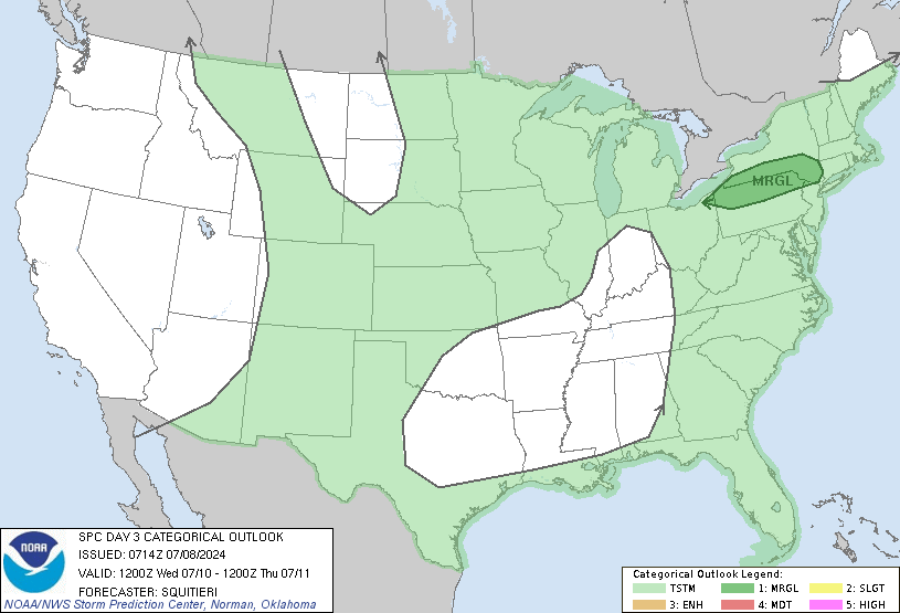
Here’s what the SPC says this morning.For days 6 and 7, storms will continue east through the Gulf Coast
States in association with the slow-moving upper trough. While
vertical wind profiles will be adequate for embedded organized
severe storms, uncertainties regarding quality the thermodynamic
environment precludes a risk area beyond day 5 at this time.
"At this time, instability is rather limited with only slight
chances for thunderstorms Thursday into Friday. Rain chances
will be ending mostly on Friday with Saturday and Sunday looking
dry."
"The lack of significant
instability will limit the severe weather threat for our area. Will
hold off mentioning anything in the HWO because of this. The biggest
concern would be the extended duration of rainfall, especially
across the northwestern counties."
FFC says no severe weather at all.The GFS and European continue to struggle with the next cold front
with the GFS bringing the front through late Thursday night and
Friday and the European bringing the front across late Friday and
Friday night. The compromise at this time increases the more
significant rain chances across n Ga Wednesday afternoon
into Thursday/Thursday night and central GA Thursday into Friday.
The front will be slow moving until a short wave gives it the needed
boost roughly on Friday. Instability continues to be limited
with just a slight chance of thunderstorms Thursday into Friday.
Rain chances will diminish/end later Friday and Friday night
with the weekend continuing to look dry.
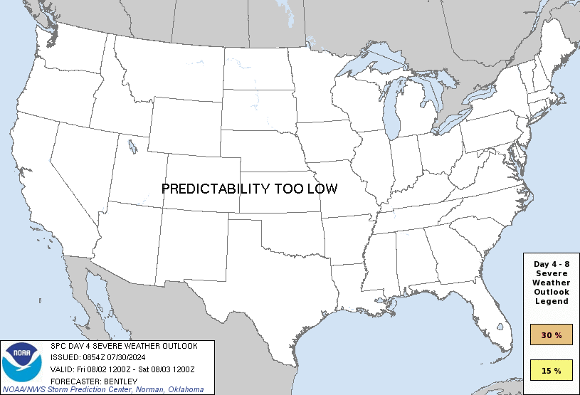
For days 5 and 6, storms will continue east through the Gulf Coast
States along and just ahead of a cold front. Indications are that
the southern-stream shortwave trough will weaken and deamplify as it
ejects northeast and becomes absorbed in northern stream. But
ensemble members are not in good agreement regarding the speed at
which this process occurs. This in addition to likelihood of weak
available instability in pre-frontal warm sector suggest low
predictability of severe storms beyond day 4.
Not at all...Low predictability does not mean "no SVR weather"....it means the details are still muddy.FFC says no severe weather at all.
SPC says the same thing.
Some severe threat might continue into day 5 over the southeast U.S.
as another in a series of shortwave troughs moving through the
synoptic trough induces cyclogenesis along cold front over the TN
Valley. This low is forecast to deepen as it approaches the Middle
Atlantic region. While a kinematic environment sufficient for
organized severe storms will reside over the southeast states, it
remains uncertain at this time whether sufficient instability will
be available for a more robust severe threat.
[\QUOTE]
SPC:Overall instability is still lacking with a chance of thunderstorms
over n and w areas Thursday and a slight chance Thursday night
and only a slight chance for the far se cwa Friday. There is some
low level shear associated with the front but it is rather unorganized
but will be monitored for any strong or severe thunderstorm potential
with future forecasts.
Also a little bit about Day 4 by SPC:The region will be influenced by the southern periphery of
moderately strong cyclonic flow aloft via a large-scale trough
centered over the Midwest. Some uncertainties exist into Thursday
especially given the likelihood of ongoing bands of storms early in
the day, but will maintain the ongoing Slight Risk given some
potential for severe thunderstorms during the morning into the
afternoon. These early-day showers and thunderstorms will be ongoing
ahead of a cold front early Tuesday from the Tennessee Valley
southwestward toward Louisiana portions of the Gulf Coast. Clouds
cover and the potential extensiveness of convection casts
uncertainty on the degree of diurnal destabilization. Regardless,
strong deep-layer/low-level shear will support at least some
possibility of organized storm modes capable of damaging winds
and/or a tornado risk particularly early in the day
A progressive largely zonal flow pattern will likely continue
through the weekend into early next week. The potential for some
strong storms could linger along the coastal Southeast States into
Day 4/Friday, but an overly organized severe potential currently
seems unlikely
4 pm update from FFCAn axis of minor instability with SBCAPE and MUCAPE values in the 500
J/kg range is anticipated along the cold front. Have maintained
the chance of thunderstorms over north and west Georgia during the
day Thursday, along with the slight chances in central and north
Georgia on Thursday night and the southeast portion of the area on
Friday. Low level shear is expected to be present in some areas
in association with the front but it still appears that it will be
unorganized. It is possible that some areas of higher low level
shear could overlap with the axis of instability so there is a
slight but non-zero threat of strong to severe storms. Will
continue to monitor severe thunderstorm potential with future
forecasts.

Latest from SPC....Southeast States...
A convective line resulting from overnight activity across southeast
TX and western portions of the Lower MS Valley will likely be moving
through MS at the beginning of period. This line will likely be
weak, owing to limited instability and displacement of the better
forcing farther west. As the shortwave trough continues
eastward/northeastward, a reinvigoration or redevelopment of the
storms within this convective line is anticipated. Storm strength
will likely be mitigated by limited instability and the tendency for
storms to be undercut but vertical shear is expected to be strong
enough (i.e. 0-6 km bulk shear greater than 50 kt) to support
rotating updrafts within any storms that are able to persist.
Primary severe threat is damaging wind gusts although a brief
tornado also appears possible.
The long term period will start will unsettled weather as a
cold front is forecast to move across the area Thursday night and
possibly early Friday. The front will bring showers and a chance of
thunderstorms. Instability associated with the front and a surface
trough out ahead of the front, will be weakening overnight Thursday
but there is decent low level shear associated as well.
There will be a marginal risk for severe thunderstorms at the
start of Thursday night favoring north and west GA.
Strong gusty winds, frequent lightning and locally heavy rain will
be the mostly likely hazards.

...Central Gulf Coast states...
Showers and thunderstorms are forecast to be ongoing along western
fringes of the outlook area at the start of the period, with
strongest storms expected to be crossing the Louisiana vicinity
where the greatest CAPE/shear combination is expected early. With
time, modest heating through likely-to-be-abundant cloud cover over
the central Gulf Coast region will boost CAPE values somewhat into
the afternoon, which should support some combination of new storm
initiation and existing convective reintensification along
eastward-moving conglomerate outflow. With strong southwesterly
flow aloft aiding potential for convective organization, potential
for damaging winds is evident. A brief tornado or two may also
occur, within the evolving complex/broken convective line where
potential for an embedded/rotating updraft or two may exist. Risk
should diminish by evening, as the airmass stabilizes diurnally.

FFC:Although the shortwave trough should de-amplify as it tracks through
the central Gulf Coast states to the southern Appalachians today,
forcing for ascent attendant to weak height falls and the entrance
region of an accompanying 80-90 kt southwesterly jet should aid in
additional storms today into the evening. While strengthening
deep-layer southwesterly winds/shear will support storm organization
as new storms form this morning into the afternoon, the combination
of weak lapse rates and modest surface heating will limit
destabilization and the overall coverage of severe storms. Higher
surface dew points across southern LA to southern AL and the western
FL Panhandle should allow for stronger instability (MUCAPE up to
1000 J/kg), while areas farther inland should have values less than
500 J/kg. Despite the relatively weaker thermodynamics, the
aforementioned strong shear/wind fields oriented nearly parallel
convective boundaries will support lines/bowing segments and some
supercell structures. In addition to a threat for damaging winds as
low-level winds strengthen, increasing hodograph curvature will also
support a tornado threat. The severe-weather threat should diminish
this evening as stronger forcing for ascent moves northeast away
from residual buoyancy across the central Gulf coast region.
A longwave upper trough will move eastward into the MS Valley
today...helping to push a cold front across AL into GA later
today into tonight. Models are consistent with weakening
instability as the front approaches...with forecast CAPES
less than 500 J/kg over north and central GA this afternoon
and overnight. However...a shortwave developing on the front
should enhance shear during that time. This would support a few
strong to severe thunderstorms across the area with damaging
wind and an isolated tornado possible during the afternoon and
evening.
 This has been bothering me for a while and because we are about to go into severe weather mode I'm hoping ya'll can help figure this out.
They do it because they want to show the area most likely to get the severe weather. Yeah, they should be consistent with spc, but I don't think one person asking will change their minds. You would need dozens of people to comment about it before they decide to change it.Does anyone know why WSBTV mets have to change the SPC color key for the severe weather? Right now it looks like a for slight risk of storms in Metro Atlanta and then the south western little area is in enhanced because they changed the colors. Are they trying to spook their audiences? I am well aware of the SPC color key and an avid amateur weather watcher but what about the rest of the people in GA that aren't? Is it worth it to try and contact Burns and see if he will respond?
Here's to hoping that the areas that were hit hard on March 19 just get gentle rains and some spring thunder and nothing else!

...Southern LA this morning to AL this afternoon...
Outflow from previous convection has stalled from northwest AL to
central MS, while the primary band of thunderstorms is progressing
eastward across southern LA in advance of an ejecting midlevel
trough over TX. A weak surface wave will move along the outflow
boundary from southern LA/MS to central AL in conjunction with the
ongoing convection, and there will be some northward moisture
advection and surface heating in advance of the convective band into
central/southern AL. Though the larger buoyancy is expected this
morning across LA with the richest low-level moisture, at least weak
surface-based CAPE (roughly 500 J/kg) is expected as far north as
the I-20 corridor in AL by this afternoon. Deep-layer vertical
shear will remain sufficient for embedded organized storms,
including supercells and/or bowing segments capable of producing
damaging winds. Likewise, some enhancement to low-level shear is
expected in response to the approach of the surface wave and
midlevel trough, with sufficient low-level shear for some tornado
threat. The severe-storm threat will begin to wane this evening as
the weak surface wave and midlevel trough move away from the
lingering weakly unstable warm sector across southern AL.

..Discussion...
A midlevel low across the south-central United States will fill and
quickly lift northeast through the day. At the surface, a weak
surface low across northern Arkansas will rapidly move northeast
into southeast Canada by tomorrow morning. A trailing cold front
will slowly push east.
Across the southeast, the low-level jet will maintain low-level
theta-e advection within a narrow corridor ahead of the slowly
eastward moving cold front. This should continue for much of the
day, before weakening this afternoon and evening as the main trough
lifts northeast from the area. The theta-e advection will maintain a
narrow plume of moist and modestly unstable air through at least
this afternoon after which the cold front should overtake most of
the modest warm sector. Before the complete erosion of the warm
sector, both shallow and deep convection will be possible. Despite
modest instability a few damaging wind gusts and a couple of
tornadoes will be possible given the strength of the low-level wind
fields.
...20Z Update...
Previous outlook reasoning generally remains on track. Primary
change with this update is to spatially confine the 5 percent
tornado probabilities to southern portions of the risk area where a
slightly more favorable thermodynamic environment exists. Latest
VWP data from KMOB sampled 0-3 KM SRH in excess of 250 M2/S2, and
any stronger cell developing in advance of the outflow
boundary/effective cold front would have some potential to develop
transient low-level rotation.
The 18Z BMX sounding showed a pronounced mid-level subsidence
inversion with a base at 700MB, contributing to only weak
surface-based buoyancy. Despite limited instability, low-level (850
mb) wind fields will strengthen through this evening across the
MRGL/SLGT risk areas, suggesting some continued potential for
isolated/widely scattered damaging gusts with the stronger
storms/short line segments.
Does anyone know why WSBTV mets have to change the SPC color key for the severe weather? Right now it looks like a for slight risk of storms in Metro Atlanta and then the south western little area is in enhanced because they changed the colors. Are they trying to spook their audiences? I am well aware of the SPC color key and an avid amateur weather watcher but what about the rest of the people in GA that aren't? Is it worth it to try and contact Burns and see if he will respond?
Here's to hoping that the areas that were hit hard on March 19 just get gentle rains and some spring thunder and nothing else!