NBAcentel
Member
Welp here we go, first time ever posting a thread, but anyways here’s the learning thread ! ???


")


Yes this is why I have always loved this site. Instead of a bunch of snarky comments, I believe this is very important to a lot of people on this board.@Myfrotho704_ instead of liking each post I'm just going to say thanks man, your visual explanations are fantastic. Way to get it going


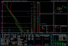
 ————————————————————-heres your average wet microburst sounding, Higher CAPE can aid stronger downdrafts (more rain/hail falling into dry layer), you can see that dry air above 750 hPa, note the more moist layer below it and that tiny little inverted V, bottom line, if you see a sounding with decent CAPE, dry air above a moist layer, know there’s a chance for a strong storm with a chance of a downburst


IN THE MOST REDNECK TERMS POSSIBLE CAN SOMEONE BREAK THIS DOWN? IM TRYING TO EXPLAIN IT TO A FEW COWORKERS BUT HAVING DIFFICULTY
View attachment 16506
Decent CAPE sounding altho it is on the lower side, decent 0-6km shear aswell, storm relative helicity is pretty high, but this sounding is lacking in richer moisture supportive of tornadoes at the surface through the column, also storms would move due west based off storm slinky, and oh yeah 0-3km lapses/CAPE is lacking aswell which is another limiting factor
This is a thunderstorm sounding, when you see those dotted lines in a sounding, that normally indicates cape, CAPE is basically the amount of energy A parcel would have if lifted up into the the atmosphere, in this sounding, there’s 2267 jkg of CAPE, that’s pretty unstable, the higher the CAPE, typically you end up with more explosive updraft development, but that’s if you have some type of forcing (outflow, cold front, warm front, lee trough, etc View attachment 16211

I notice several CAPE values at the bottom of the chart: SBCAPE, MJCAPE and DCAPE. What is the difference between each? Which should we look first when looking at a sounding?
View attachment 17416
Welcome aboard!Thanks for the great information and explanations. I have been seeing these graphs for years and never could quite grasp what it was telling me. After this thread, I have a much better idea. Still not all the way there, but gaining on it.
Setting spring severe aside when looking for summer tstorms would you look more toward MLCAPE vs SB? I've noticed many times in the summer when we get capped our SB will be in the 2000+ range but ml is much less and we have a ton of flat cumulusIts really convective energy at different levels and points for layman terms. For instance SBcape stands for surface based cape which is the convective energy starting at ground level. DCape is downdraft cape which us used to determine the strength of downdrafts. Presence of MLCape with low SBcape tells you that there is a cap and any convection at that point would be elevated.
I look at SBcape first and then on most soundings you will see 0-3km Cape which I look at next.
Setting spring severe aside when looking for summer tstorms would you look more toward MLCAPE vs SB? I've noticed many times in the summer when we get capped our SB will be in the 2000+ range but ml is much less and we have a ton of flat cumulus
Sent from my SM-G955U using Tapatalk
Also another thing i read about that day was there was controlled forest burning in south america which the smoke travelled up into Mississippi and alabama which may have aided in the storms any ideas on how that wouldve effected things?
, im guessing we got lucky then last storm system that the low wasn't closer too us. More shear and a stronger LLJ would've aided in more instability. Provided the discreet mode of the supercells.Interesting with that setup in 2011, the tornadoes you either had were large stovepipes with side vortices (Tuscaloosa), large wedge tornadoes with the Mesos scraping the ground (Phil Campbell/Hackleburg), or had tornadoes that were very tilted (Cullman)
, im guessing we got lucky then last storm system that the low wasn't closer too us. More shear and a stronger LLJ would've aided in more instability. Provided the discreet mode of the supercells.
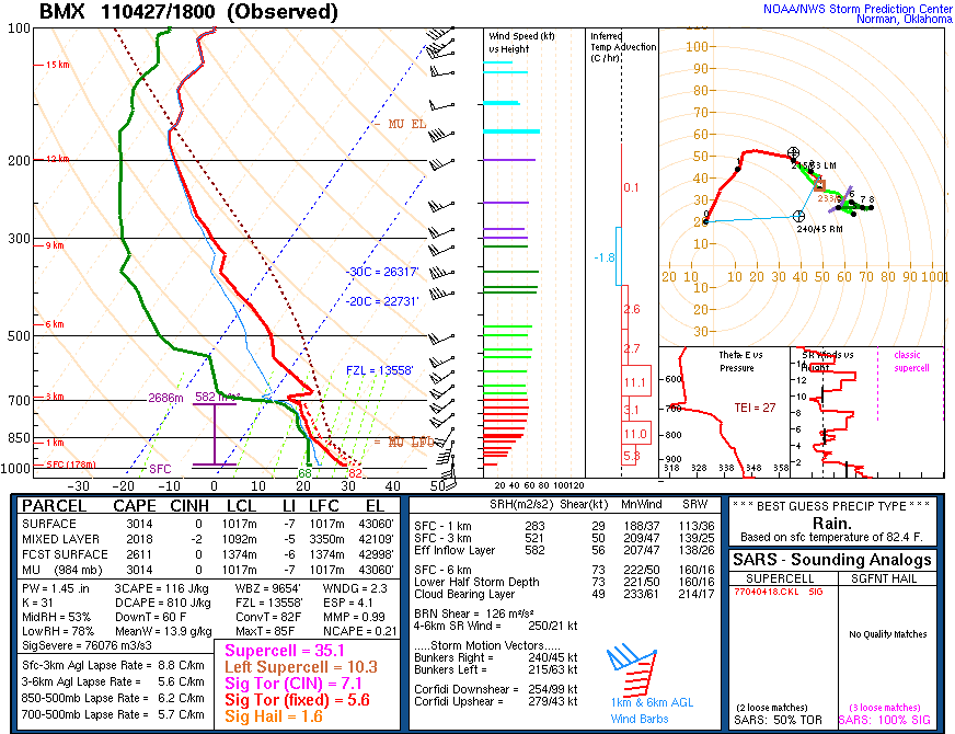
Can somebody help breakdown what made april 27th 2011, so bad in terms of meteorological factors? Because ive heard james spann say something like for that day 63 or 64 things on a checklist of 67 for severe weather were in place. Im just curious to what made is SO bad. Living here in it and being around when it happened ive always been traumatized by how the day felt and how many horrible things happened that day. It was what triggered me to want to know more about the weather and being aware of it. But thanks in advance if anyone wants to help or explain the details. Ive looked at weather soundings from that day and dont understand what factors made it so bad. Other than an outflow boundary sitting on top of birmingham and dryline approaching during peak daytime heating. Along with high helicityView attachment 17846