

-
Hello, please take a minute to check out our awesome content, contributed by the wonderful members of our community. We hope you'll add your own thoughts and opinions by making a free account!
You are using an out of date browser. It may not display this or other websites correctly.
You should upgrade or use an alternative browser.
You should upgrade or use an alternative browser.
Pattern July Fry
- Thread starter SD
- Start date
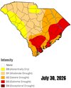
Yep lots of brown yards and bare river birch trees across the Pee Dee.


Even down here the dewpoints are actually 66-67! That’s the lowest I’ve seen quite possibly all month. Temp is 93.3 here vs 100.5 exactly 24 hrs ago (high was 101.1). Skies still have ugly haze with only a few clouds. Winds are light/variable vs yesterday’s hot SW winds.

84/54, 3.12" for the month will be the final total
Dew point is only 68, 91° here in Mount PleasantEven down here the dewpoints are actually 66-67! That’s the lowest I’ve seen quite possibly all month. Temp is 93.3 here vs 100.5 exactly 24 hrs ago (high was 101.1). Skies still have ugly haze with only a few clouds. Winds are light/variable vs yesterday’s hot SW winds.


this looks better
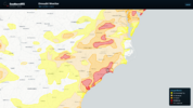
Already down to 70

- Joined
- Jan 5, 2017
- Messages
- 3,811
- Reaction score
- 6,066
Wow! 65.8 dewpoint of 64.6, need a blanket out here on the veranda.

Heelyes
Member
Incredible morning 58/57

SuperNET
Member
66/60 here - what a nice treat
Max 99.5
Min 64.9
Avg 80.4
Rain 9.24
22213 lightning strikes
Min 64.9
Avg 80.4
Rain 9.24
22213 lightning strikes
- Joined
- Jan 5, 2017
- Messages
- 3,811
- Reaction score
- 6,066
Max 95.7 (7/2)
Min 65.5 (7/31)
Avg 78.4
Rain 6.18"
Lightning 14724
Min 65.5 (7/31)
Avg 78.4
Rain 6.18"
Lightning 14724
Heelyes
Member
Still under 5” for the month
maxT 97 (7/2)
mean maxT 89.7
minT 65 (7/24)
mean minT 72.4
avg 81.0
precip 3.12"
18/31 90F+
6/31 95F+
max minT 77F (7/2)
min maxT 73F (7/24)
mean maxT 89.7
minT 65 (7/24)
mean minT 72.4
avg 81.0
precip 3.12"
18/31 90F+
6/31 95F+
max minT 77F (7/2)
min maxT 73F (7/24)

CNCsnwfan1210
Member
Min T: 64 (7/31)
Max T : 99 (7/3)
Average mean temp : 80.1
Precip total: 8.13 inches
Lightning strikes: 24,232
Sent from my iPhone using Tapatalk
Max T : 99 (7/3)
Average mean temp : 80.1
Precip total: 8.13 inches
Lightning strikes: 24,232
Sent from my iPhone using Tapatalk
SuperNET
Member
Max Temps: too hot
Min Temps: too hot
Average temps: too hot
Rain: not enough
You need a t-storm to have lightning - not so much
Min Temps: too hot
Average temps: too hot
Rain: not enough
You need a t-storm to have lightning - not so much

Brent
Member
I'd say we made up for however "cool" the summer started...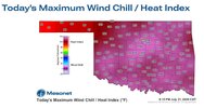

Iceagewhereartthou
Member
They also dipped below 73 for the first time since June 25th with a 72 yesterday and 66 this morning.I forgot to mention that CAE finally reached 100 on July 28th although Augusta still hasn’t.
Given the number of mid to upper 90s at GSP and CLT this summer I am shocked CAE hasn't had at least 6-8 100+ readings so far. They escaped the worst of it so far.

Max 100
Min 62
Avg 79
Rain 6.11
Lightning (since we're counting lol)
9129
Min 62
Avg 79
Rain 6.11
Lightning (since we're counting lol)
9129
lexxnchloe
Member
Raleigh ended up 1.1 above normal
| 2026-07-01 | 98 | 72 | 85.0 | 6.7 | 0 | 20 | 0.00 | 0.0 | 0 |
| 2026-07-02 | 100 | 74 | 87.0 | 8.6 | 0 | 22 | 0.00 | 0.0 | 0 |
| 2026-07-03 | 99 | 76 | 87.5 | 9.0 | 0 | 23 | 0.00 | 0.0 | 0 |
| 2026-07-04 | 98 | 77 | 87.5 | 8.9 | 0 | 23 | 0.00 | 0.0 | 0 |
| 2026-07-05 | 95 | 72 | 83.5 | 4.8 | 0 | 19 | 0.10 | 0.0 | 0 |
| 2026-07-06 | 94 | 72 | 83.0 | 4.2 | 0 | 18 | T | 0.0 | 0 |
| 2026-07-07 | 91 | 71 | 81.0 | 2.1 | 0 | 16 | 0.22 | 0.0 | 0 |
| 2026-07-08 | 94 | 73 | 83.5 | 4.6 | 0 | 19 | 0.04 | 0.0 | 0 |
| 2026-07-09 | 94 | 72 | 83.0 | 4.0 | 0 | 18 | 0.00 | 0.0 | 0 |
| 2026-07-10 | 92 | 72 | 82.0 | 3.0 | 0 | 17 | 0.24 | 0.0 | 0 |
| 2026-07-11 | 90 | 71 | 80.5 | 1.5 | 0 | 16 | 0.06 | 0.0 | 0 |
| 2026-07-12 | 85 | 72 | 78.5 | -0.6 | 0 | 14 | T | 0.0 | M |
| 2026-07-13 | 78 | 70 | 74.0 | -5.1 | 0 | 9 | 0.17 | 0.0 | 0 |
| 2026-07-14 | 88 | 67 | 77.5 | -1.6 | 0 | 13 | 0.00 | 0.0 | 0 |
| 2026-07-15 | 93 | 64 | 78.5 | -0.6 | 0 | 14 | 0.00 | 0.0 | M |
| 2026-07-16 | 96 | 72 | 84.0 | 4.9 | 0 | 19 | 0.00 | 0.0 | 0 |
| 2026-07-17 | 95 | 76 | 85.5 | 6.4 | 0 | 21 | 0.00 | 0.0 | 0 |
| 2026-07-18 | 95 | 76 | 85.5 | 6.4 | 0 | 21 | 0.00 | 0.0 | 0 |
| 2026-07-19 | 93 | 74 | 83.5 | 4.4 | 0 | 19 | T | 0.0 | 0 |
| 2026-07-20 | 90 | 72 | 81.0 | 1.9 | 0 | 16 | 0.56 | 0.0 | 0 |
| 2026-07-21 | 92 | 72 | 82.0 | 2.9 | 0 | 17 | T | 0.0 | 0 |
| 2026-07-22 | 90 | 70 | 80.0 | 1.0 | 0 | 15 | 1.93 | 0.0 | 0 |
| 2026-07-23 | 73 | 67 | 70.0 | -9.0 | 0 | 5 | 1.16 | 0.0 | 0 |
| 2026-07-24 | 71 | 65 | 68.0 | -11.0 | 0 | 3 | 0.10 | 0.0 | 0 |
| 2026-07-25 | 74 | 66 | 70.0 | -8.9 | 0 | 5 | 0.36 | 0.0 | 0 |
| 2026-07-26 | 83 | 66 | 74.5 | -4.4 | 0 | 10 | 0.00 | 0.0 | 0 |
| 2026-07-27 | 87 | 69 | 78.0 | -0.9 | 0 | 13 | 0.00 | 0.0 | 0 |
| 2026-07-28 | 87 | 71 | 79.0 | 0.2 | 0 | 14 | 0.01 | 0.0 | 0 |
| 2026-07-29 | 88 | 68 | 78.0 | -0.8 | 0 | 13 | 0.00 | 0.0 | 0 |
| 2026-07-30 | 86 | 65 | 75.5 | -3.2 | 0 | 11 | 0.00 | 0.0 | 0 |
| 2026-07-31 | 87 | 63 | 75.0 | -3.7 | 0 | 10 | 0.00 | 0.0 | 0 |
| Sum | 2776 | 2187 | - | - | 0 | 473 | 4.95 | 0.0 | - |
|---|---|---|---|---|---|---|---|---|---|
| Average | 89.5 | 70.5 | 80.0 | 1.1 | - | - | - | - | 0.0 |
| Normal | 88.5 | 69.3 | 78.9 | - | 0 | 431 | 4.18 | 0.0 |

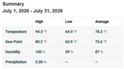
Gauge precip: 6.5"

Max: 99.9
Min: 64.6
Avg: 81.1
Rain: 5.53"
Min: 64.6
Avg: 81.1
Rain: 5.53"

Looks like this ended up being the warmest July on record in the contiguous United States and indeed the warmest month on record, narrowly edging out the infamous July 1936. Of course, this was largely driven by warm overnight lows. This was the sixth warmest as far as high temperatures are concerned and July 1936 still comfortably reigns supreme there (July 2026 obviously has the record for warmest overnight lows).
It always amazes me how hot the Dust Bowl era was, especially in the context of an overall cooler climate. It’s still the case that around half of all US states’ record high temperatures were set in the 1930s, which is wild.
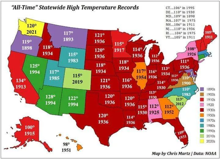
It always amazes me how hot the Dust Bowl era was, especially in the context of an overall cooler climate. It’s still the case that around half of all US states’ record high temperatures were set in the 1930s, which is wild.

Drizzle Snizzle
Member
Apparently it was hotter in the Dust Bowl era in Michigan than it was in North Carolina.Looks like this ended up being the warmest July on record in the contiguous United States and indeed the warmest month on record, narrowly edging out the infamous July 1936. Of course, this was largely driven by warm overnight lows. This was the sixth warmest as far as high temperatures are concerned and July 1936 still comfortably reigns supreme there (July 2026 obviously has the record for warmest overnight lows).
It always amazes me how hot the Dust Bowl era was, especially in the context of an overall cooler climate. It’s still the case that around half of all US states’ record high temperatures were set in the 1930s, which is wild.

NoSnowATL
Member
Man the early 1900s was hot, must have been all those gasoline cars and manufacturing plants.Apparently it was hotter in the Dust Bowl era in Michigan than it was in North Carolina.

Looks like this ended up being the warmest July on record in the contiguous United States and indeed the warmest month on record, narrowly edging out the infamous July 1936. Of course, this was largely driven by warm overnight lows. This was the sixth warmest as far as high temperatures are concerned and July 1936 still comfortably reigns supreme there (July 2026 obviously has the record for warmest overnight lows).
It always amazes me how hot the Dust Bowl era was, especially in the context of an overall cooler climate. It’s still the case that around half of all US states’ record high temperatures were set in the 1930s, which is wild.
I find it insane that Alaska had a higher record temperature than Hawaii. Jesus.
Hawaii is surprisingly mild. The sea temperatures are cooler than you’d expect at that latitude driven by ocean currents and the fact that it’s tropical means that it has a pretty consistent climate with few extremes either way. You get a little more variance on the big island given its size but then a lot of that is at higher elevation and thus not as hot, anyways. The majority of the big island is at a high enough elevation that 50s-70s tend to be pretty predominant. Of course, on Mauna Kea and Mauna Loa, it is more like 20-40 and snow is not uncommon.I find it insane that Alaska had a higher record temperature than Hawaii. Jesus.
Alaska, on the other hand, is huge and has land that is many hundreds of miles away from any moderating ocean influence, so when a heat wave does happen it can get pretty hot. Similarly, a portion of Canada near 50N actually hit 121F in June 2021 to set the country’s all time high, which is over 10 degrees warmer than NC’s! It’s actually pretty interesting how mild NC’s all time high is.
This all reminds me of an interesting stat I once heard that Tallahassee, FL has a lower all time low (-2F) than Bergen, a major port city in Norway, that has its climate heavily moderated by the North Sea. Of course, Bergen is in general much colder than Florida, but given the right setup (February 1899), it actually got colder in Florida!
Hawaii is surprisingly mild. The sea temperatures are cooler than you’d expect at that latitude driven by ocean currents and the fact that it’s tropical means that it has a pretty consistent climate with few extremes either way. You get a little more variance on the big island given its size but then a lot of that is at higher elevation and thus not as hot, anyways. The majority of the big island is at a high enough elevation that 50s-70s tend to be pretty predominant. Of course, on Mauna Kea and Mauna Loa, it is more like 20-40 and snow is not uncommon.
Alaska, on the other hand, is huge and has land that is many hundreds of miles away from any moderating ocean influence, so when a heat wave does happen it can get pretty hot. Similarly, a portion of Canada near 50N actually hit 121F in June 2021 to set the country’s all time high, which is over 10 degrees warmer than NC’s! It’s actually pretty interesting how mild NC’s all time high is.
This all reminds me of an interesting stat I once heard that Tallahassee, FL has a lower all time low (-2F) than Bergen, a major port city in Norway, that has its climate heavily moderated by the North Sea. Of course, Bergen is in general much colder than Florida, but given the right setup (February 1899), it actually got colder in Florida!
That absolutely amazing 121 was made possible by a drought there. Barring large amounts of additional global warming in the future, I can’t see anything exceeding 115 in NC anytime soon. If any location will eventually do it, it would probably be RDU during a bad drought lol.
Amazingly, Las Vegas’ hottest ever is “only” 120.
Hawaii is surprisingly mild. The sea temperatures are cooler than you’d expect at that latitude driven by ocean currents and the fact that it’s tropical means that it has a pretty consistent climate with few extremes either way. You get a little more variance on the big island given its size but then a lot of that is at higher elevation and thus not as hot, anyways. The majority of the big island is at a high enough elevation that 50s-70s tend to be pretty predominant. Of course, on Mauna Kea and Mauna Loa, it is more like 20-40 and snow is not uncommon.
Alaska, on the other hand, is huge and has land that is many hundreds of miles away from any moderating ocean influence, so when a heat wave does happen it can get pretty hot. Similarly, a portion of Canada near 50N actually hit 121F in June 2021 to set the country’s all time high, which is over 10 degrees warmer than NC’s! It’s actually pretty interesting how mild NC’s all time high is.
This all reminds me of an interesting stat I once heard that Tallahassee, FL has a lower all time low (-2F) than Bergen, a major port city in Norway, that has its climate heavily moderated by the North Sea. Of course, Bergen is in general much colder than Florida, but given the right setup (February 1899), it actually got colder in Florida!
In hindsight it does make sense, but man does it blow my mind still. I didn't even know about Canada's AT record too, that's wild.

- Joined
- Jan 23, 2021
- Messages
- 4,614
- Reaction score
- 15,231
- Location
- Lebanon Township, Durham County NC
I was in grad school at the time in Cola when that was set. It was even set at Owens field, about half a mile from where I lived. Some hellacious storms broke that heatwave.Looks like this ended up being the warmest July on record in the contiguous United States and indeed the warmest month on record, narrowly edging out the infamous July 1936. Of course, this was largely driven by warm overnight lows. This was the sixth warmest as far as high temperatures are concerned and July 1936 still comfortably reigns supreme there (July 2026 obviously has the record for warmest overnight lows).
It always amazes me how hot the Dust Bowl era was, especially in the context of an overall cooler climate. It’s still the case that around half of all US states’ record high temperatures were set in the 1930s, which is wild.