• Hello, please take a minute to check out our awesome content, contributed by the wonderful members of our community. We hope you'll add your own thoughts and opinions by making a free account!

Severe January 9th 2022 MS/AL slight risk

Z

Zander98al

Guest
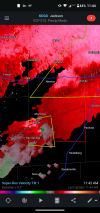
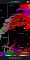
Looks like a decent squall line will come through this afternoon. 5% tornado risk area, contemplated even making a thread lol, but the updraft helicity swaths go wild in central and southern half of Alabama. Not to mention the very high lapse rates this go around.
day1probotlk_1300_torn.gif
 
Turning with height is impressive with this setup. Atmosphere is taking full advantage of the warm front in aiding in turning with height. Almost a 90° angle from the surface up. hrrr_2022010912_009_31.72--87.63.png
 
For the short term. Dangerous cell with potential for a tornado is moving through south MSScreenshot_20220109-112604.png
 
Strong rotation now Screenshot_20220109-114455.png
 

Attachments

  • Screenshot_20220109-114455.png
    Screenshot_20220109-114455.png
    490.9 KB · Views: 5
Two strong rotations on radar right now. The bottom most one that's tornado warned has very good structure. Looks like this is the one that falls into the mesoscale discussion from earlierScreenshot_20220109-142650.png
 
Back
Top