-
Hello, please take a minute to check out our awesome content, contributed by the wonderful members of our community. We hope you'll add your own thoughts and opinions by making a free account!
You are using an out of date browser. It may not display this or other websites correctly.
You should upgrade or use an alternative browser.
You should upgrade or use an alternative browser.
Wintry January 23rd-27th 2026
- Thread starter SD
- Start date


Two positives. 
That the 6z run was bananas and the 12z run will roughly look like the aifs
We got some positives here if you want to try and dig back toward front end snow/sleet in portions of the Carolinas. Going to be icy still
Always good to have 2-3 rows of counties below you! This is getting real now!
Long lead time on the watch, from conservative GSP
Long lead time on the watch, from conservative GSP
Blue_Ridge_Escarpment
Member
Been the theme of the 12Z suitesouth trend?
I'm thinking if this is the start of a trend that carries through the next 24 hours, it's back to boom time.
Makeitsnow
Member
euro a few degrees colder than prior run
bdake
Member
Live in between BHM and HSV. Folks around here are already writing off even the possibility of ice. They're expecting just rain. Hope we don't get caught with our pants down.
Sent from my iPhone using Tapatalk
Sent from my iPhone using Tapatalk
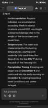
I asked AI about the Dec 2002 ice storm for GSP and this was what it found!Definitely getting worried about the growing ice storm threat in the carolinas from this storm.
The hardest part about these sorts of events is predicting how much of our precip will be sleet or freezing rain.
I can’t say I’ve seen too many winter storms historically like this that had a +10C warm nose aloft and surface temps were in the low to mid 20s like a lot of the models are showing atm
Attachments
Hopefully this is better

wow
Member
Euro has regressed some .. baja west, northern s/w slower.
Brandon10
Member
Definitely seeing some baby steps with 12z suite....Just like the north trend that happened yesterday, if we are going to trend back south it is going to take several model runs to see changes esp with recon data later tonight. May not trend south, but for now, the bleeding has stopped.
I still will hang on to the idea that baja lows have their own mind and really do not like to cooperate and move east quickly. We also have seen a lot of NS energy this year weaken or move east closer to go time.
I still will hang on to the idea that baja lows have their own mind and really do not like to cooperate and move east quickly. We also have seen a lot of NS energy this year weaken or move east closer to go time.
Webberweather53
Meteorologist
I asked AI about the Dec 2002 ice storm for GSP and this was what it found!
Thanks for that. I know when I looked into it on the nc state climate office archive, temps in Raleigh were between 26-30F during the worst of the freezing rain.
28-29F ish seems to be about the magic number(s) to get hammered with freezing rain. This upcoming storm is a unique one in that the low level cold is stronger than Dec 2002, as is the warm nose aloft potentially
The flatter those wind barbs become across Ark/TN , the better. Need about 2 more small ticks to the right and its Bingo timeHopefully this is better
View attachment 187010
This is what I was hoping for and realistically, the best we could expect right now. We're going to trend one way or another from here...some slow movement back flat/south/cold are possible. That remains within the realm of possibility. Continuing to proceed amped and warm would have been quite bad, IMO.Definitely seeing some baby steps with 12z suite....Just like the north trend that happened yesterday, if we are going to trend back south it is going to take several model runs to see changes esp with recon data later tonight. May not trend south, but for now, the bleeding has stopped.

Welp, I was wrong. Even with the better look early on, the 12z ECMWF completely breaks down the CAD and looks very similar to the previous run.
Surface temps are somehow even warmer it looks like?
iGRXY
Member
The good news with the euro is the confluence over the northeast looks a lot better
I will be surprised if the CAD gets broken down as quickly as the Euro advertises. QPF trends need to be monitored
Here is the Euro from today v/s yesterday...yesterday had that big wintery run. It's not just Baja energy it's the upper low to our NE lifting out quicker.
Just a bad break....or lucky break if you want to avoid ice.

Just a bad break....or lucky break if you want to avoid ice.
At this point we’re dealing with expanding or contracting the precip shield and thermo profile adjustments.
The changes aren’t north or south it’s really can you get some more sleet or even snow at the onset and how much ice accretion are you getting total? These are the adjustments. I think if you’re living in NC you are looking for minor adjustments to get a little snow and maybe a lot of sleet to cut into FZ totals.
I still believe most everyone in NC/SC/GA/TN is dealing with ICE and that is what you should be preparing for.
Virginia is more snow BUT a change over will come.
Up north it’s how much snow shield can expand or contract.
Adjustments at this range won’t waver too much on generally what everyone will see. Just tweaking amounts here and there
iGRXY
Member
There’s no way temps would be worse with the changes at H5. And killing this level of CAD. The euro is flat wrong in that aspect.
Us folk in Central Alabama, Birmingham and just south need to not write anything off at this moment. Any little trend south means a big change for us
Very small changes will make a big difference on the battle lines in a wedge scenario over here.At this point we’re dealing with expanding or contracting the precip shield and thermo profile adjustments.
The changes aren’t north or south it’s really can you get some more sleet or even snow at the onset and how much ice accretion are you getting total? These are the adjustments. I think if you’re living in NC you are looking for minor adjustments to get a little snow and maybe a lot of sleet to cut into FZ totals.
I still believe most everyone in NC/SC/GA/TN is dealing with ICE and that is what you should be preparing for.
Virginia is more snow BUT a change over will come.
Up north it’s how much snow shield can expand or contract.
Adjustments at this range won’t waver too much on generally what everyone will see. Just tweaking amounts here and there
Shinrin
Member
I live in gadsden, we are prepared for the ice of it does come here. Better to be safe than sorry.Live in between BHM and HSV. Folks around here are already writing off even the possibility of ice. They're expecting just rain. Hope we don't get caught with our pants down.
Sent from my iPhone using Tapatalk
Welp, I was wrong. Even with the better look early on, the 12z ECMWF completely breaks down the CAD and looks very similar to the previous run.
Drier run letting dew points rise before evaporative cooling?
Brandon10
Member
EW. The 500 looked better through the midrange. Then everything went bad. All the moving around of the northern stream and that low killed any improvements early
Euro has Raleigh flipping to rain Sunday evening as bulk of precip comes through...it's actually a relief not having to deal with frzn
Yesterday Euro had Raleigh in low 20s with heavy precip...now at 32F with the precip


Yesterday Euro had Raleigh in low 20s with heavy precip...now at 32F with the precip
AIFS hanging onto CAD longer vs Euro:


Mahomeless
Member
- Joined
- Oct 17, 2023
- Messages
- 900
- Reaction score
- 2,158
Here is the Euro from today v/s yesterday...yesterday had that big wintery run. It's not just Baja energy it's the upper low to our NE lifting out quicker.
Just a bad break....or lucky break if you want to avoid ice.
View attachment 187013
The upper low ejecting sooner is directly related to the northern stream dig....the more it digs, the more the heights raise in the east and scoots the upper low out. Also, the more it digs, the more Baja interaction. It's all related to the northern stream. Push it east and let it "slide" to the southeast, and we are right back to glory runs for everyone. IMO, that is the feature that should be focused on....everything else will fall in line with it.
Retreating HP trend on Euro...makes sense. How many times have we seen that over the year...sucks to miss this potential event but will keep our power on this weekend.

This run has revived my hope that the freezing rain totals might be less than previously advertised. If future Euro runs keep trending like this,Euro has Raleigh flipping to rain Sunday evening as bulk of precip comes through...it's actually a relief not having to deal with frzn
Yesterday Euro had Raleigh in low 20s with heavy precip...now at 32F with the precip
View attachment 187014View attachment 187015
RDU may dodge a large caliber bullet.
The AI Euro keeps most of central NC in the 20-25 degree range for the duration while the regular Euro scours away the wedge in the course of a few hours (RDU warms 4 degrees between one hourly panel and the next towards the end of the storm). Huge differences between the AI and non-AI model.

WSNC
Member
I don't believe the euro is known for handling CAD well.
a_gilmore88
Member
Given the usual difficulties with models and CAD, and the consensus behind a STRONG CAD otherwise, the EURO can be tossed out. It’s just not going to happen that way.