Hopefully Euro keeps amping and kills this threat completely. It wouldn’t take much for this to be a nuisance event. Want nothing to do with freezing rain
Got the 60F’s rapidly approaching…

Got the 60F’s rapidly approaching…
For NC there is no way out of sig winter storm. I mean its 1.5 qpf+ with temps in low 20's. Frustrating, as I'd prefer snow, then sleet as second choice for ptype. But of every run out there, trend from every model. Its all frozen no matter what.Folks I would not write this storm off this is going to be a dangerous storm for some. Somebody is going to get rocked with heavy snow sleet and freezing rain with power outages. The bigger story is the cold coming after. Going to be an interesting 2 days of model runs. Keep the faith!
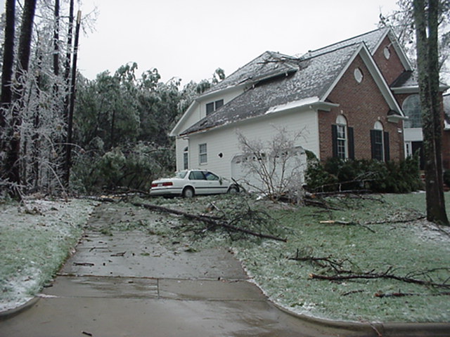
You must not been around then , December 2002What is a storm analog for temperatures in the upper teens/low 20s and freezing rain the entire time? Is there one? That is what is forecast for us on the EURO. It is just hard to fathom that taking place for multiple days, especially when you consider how much modeling usually underestimates CAD in the first place.
 climate.ncsu.edu
 spectrumlocalnews.com
What is a storm analog for temperatures in the upper teens/low 20s and freezing rain the entire time? Is there one? That is what is forecast for us on the EURO. It is just hard to fathom that taking place for multiple days, especially when you consider how much modeling usually underestimates CAD in the first place.
You must not been around then , December 2002
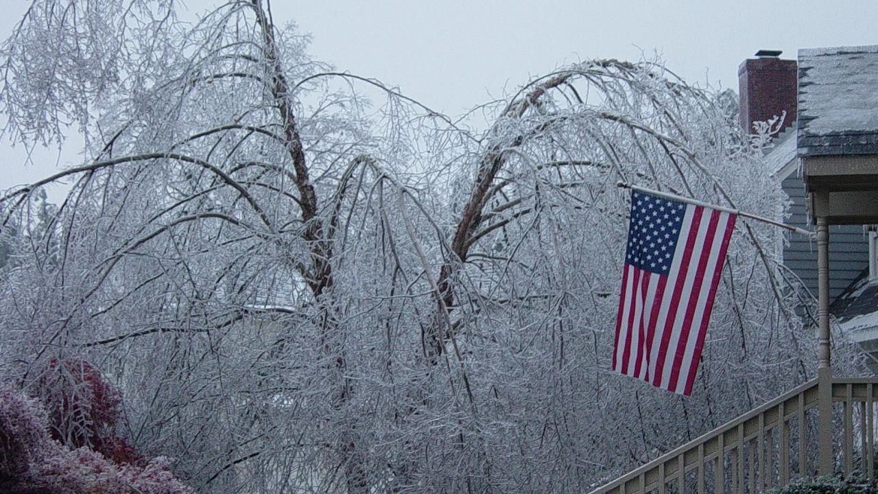
plenty of articles and wx studies. just google. Hers one
NC Extremes: An Ice Storm for the Ages - North Carolina State Climate Office
This post is part of our year-long series about North Carolina's weather extremes. Winter weather in North Carolina can be a fickle thing. When cold air and moisture come together at the right time, the outcome can be an impressive snowstorm. However, even small temperature differences...
A crippling ice storm struck North Carolina 21 years ago
It took up to 10 days for power to be restored.

The analog is 2002 …. That’s the one
Sent from my iPhone using Tapatalk
If you want to believe the outlier model that erodes CAD faster than the others, sure.Yesterday the ATL was looking at catastrophic sleet/frzn and now it’s going to have to run the AC on Sunday.
Meteo from yesterday
View attachment 186840
Latest
View attachment 186841
You mean the UK or the Euro? Two of the top performing models?If you want to believe the outlier model that erodes CAD faster than the others, sure.
Good luck with that


When was this put out?KATL forecast Discussion
Saturday into Sunday we will begin to see the overall troughing
pattern begin to dive south into the southeastern U.S. while the low
pressure system currently off the Pacific begins to push inland.
This setup creates an atmospheric river from the Mexican Pacific
coast, across the entire southern U.S., and out across to the
Carolinas beginning Fri afternoon. The timing of how this Pacific low
pressure system moves is going to in turn factor into how long we
are expecting potential impacts. Current timing has this system
moving rapidly across the south states through the weekend and up
the eastern seaboard and pulling out of GA Monday morning/early
afternoon.
Some things to talk about with this event. This is shaping up to be
a potentially high impact event with moderate to major impacts. With
this amount of model consistency in the overall setup we are gaining
confidence that this could be a long duration event as well. With
initiation as early as Saturday afternoon and wintry precip looking
to extend into Sunday night/Mon morning. At this point we are
confident that wintry precip will affect north Georgia for areas
along and north of I-20. The area south of I-20 down to Macon and
Columbus are a little more uncertain but models are consistently
forecasting wintry precip for this area as well. A few factors into
how much/what type of wintry precip we receive are the influence of
the wedge expected to take shape and then how far north the front
pushes. When it comes to the wedge, current thinking is that snow
will be the main precip type for far north Georgia and wintry
mix/freezing rain will become the main concern for the remainder of
the north Georgia including the ATL/AHN areas. There is still a
decent shot that we see this freezing rain transition to more of a
snow event as we get into late Sunday and Monday but that is still
uncertainty.
Focusing on the probabilistic information for now.
--> 40-50% chance for 0.5" or greater of ice accumulation through
the weekend for the areas north of I-20.
--> 25-30% chance for 0.75" or greater of ice accumulation through
the weekend for the areas north of I-20.
--> 15-20% chance for 1" or greater of ice accumulation through the
weekend for the areas north of I-20.
--> 30-45% chance for 2" or greater of snow accumulation through the
weekend for the areas north of I-20.
For now the main thing to focus on is being prepared for a
potentially high impact event this weekend. We will likely see more
changes over the coming days but please make sure you have a plan to
endure this event which could include power outages.
Once this system exits the area Monday, a good portion of north GA
will continue to see impacts as Temps Mon are not expected to get to
much above freezing. Any accumulations that linger will most likely
continue through Tue when temps are expected to get up into the
upper 30s to near 40.
Sent from my iPhone using Tapatalk

When was this put out?


Better press with the cold in the east too. Follows the 6z euro. Interesting day of model watching coming up.UK at 06z taking a step away from warm/amplifiedView attachment 186846View attachment 186847
Just now getting up and seeing 0 and 6z stuff so don’t crucify me if I miss somethin, but AIFS ticking to more separation up top as well. ECMWF trend similarUK at 06z taking a step away from warm/amplifiedView attachment 186846View attachment 186847

I remember 2002 well. We had 10 trees laying in our driveway. WPC discussion made me feel a little better. Hopefully we can get more separation with the baja and stay snow/sleet. Today's runs will be crucial. Either way a sig storm is on the way.For NC there is no way out of sig winter storm. I mean its 1.5 qpf+ with temps in low 20's. Frustrating, as I'd prefer snow, then sleet as second choice for ptype. But of every run out there, trend from every model. Its all frozen no matter what.
I just hope we don't spend 80-90% of the storm with frzng rain as the p type. Cause no matter what model ends up correct, we aint crossing out of the low 20's. It will be December 2002 repeat possibly worse if we end up with frzng rain being our dominant ptype.. Back then, I think we got like 1.0-1.3 as frzng rain ptype after a quick burst of snow/sleet at onset, temps hovering around 19-22. Just like this is gonna be.
My Prep plans will be adjusted Thursday morning, if the jury decides at 12z and 0z tonight, the frzng rain captures 75% plus of my p type.
Praying American models can win one, be right just once. But if your in piedmont NC/Foothills, Northern coastal plain in NC. If anything we need to pray the euro/ukmet are sniffing glue. If not, our situation just got worse. Goes from a snow/sleeted shut in for days. To a 1- 3 inch snow/sleet shut in , with major timber damage and very wide spread power outages.
It is also clear why lack of separation shows so much change downstream. The polar vortex in SE Canada can escape and move much further notheast, adding to the lack of cold press.Just now getting up and seeing 0 and 6z stuff so don’t crucify me if I miss somethin, but AIFS ticking to more separation up top as well. ECMWF trend similar
View attachment 186848
I agree, I don’t fully buy into the Euro’s solution just like fully buying into the GFS maps with all that snow was a good idea either. I think somewhere in between is the right call at this current moment.I get the Dec 2002 discussion and respect it (and lived thru it). But anecdotally through the years, the vast majority of these crazy ice scenarios in CAD regions showing up 3 to 4 days in advance get saved by sleet being the predominant precip type. If I recall, usually starts to resolve that way 48 hours before onset.
That said, someone's gonna get hammered w/ an ice storm, but likely not in the large area currently depicted.
Remember it well. No power for 8 daysYou must not been around then , December 2002
plenty of articles and wx studies. just google. Hers one
NC Extremes: An Ice Storm for the Ages - North Carolina State Climate Office
This post is part of our year-long series about North Carolina's weather extremes. Winter weather in North Carolina can be a fickle thing. When cold air and moisture come together at the right time, the outcome can be an impressive snowstorm. However, even small temperature differences...
A crippling ice storm struck North Carolina 21 years ago
It took up to 10 days for power to be restored.
Yep. Desperately need to see this continue thru the 12z suite and hopefully the obs from recon can help us trend back colder into tonight’s runs.Just now getting up and seeing 0 and 6z stuff so don’t crucify me if I miss somethin, but AIFS ticking to more separation up top as well. ECMWF trend similar
View attachment 186848

It’s interesting to see WPC bringing up the north trend potentially being a “slight mirage.” Seen a few other forecasters (not all southerners, so not all wishcasting) mention their skepticism. Can’t tell if that’s a general incredulity at the shift or an opinion with merit. Probably have 2 to 3 runs to figure that out.
I mean how does this happen? Somebody with more knowledge than me please explain how it can just bully all that hp out the way? I want to not believe it either, but I feel that's straw grasping since they all do except the GFS. And I'll never get letdown by the GFS again when it's on an island
View attachment 186849

I get the Dec 2002 discussion and respect it (and lived thru it). But anecdotally through the years, the vast majority of these crazy ice scenarios in CAD regions showing up 3 to 4 days in advance get saved by sleet being the predominant precip type. If I recall, usually starts to resolve that way 48 hours before onset.
That said, someone's gonna get hammered w/ an ice storm, but likely not in the large area currently depicted.

Essentially they’re unsure of trends at this point being the solution due to uncertainty about the northern stream energy which is currently in an area with poor obs, so could be poorly handled by models.Does anyone have the explanation about what they mean…
Sent from my iPhone using Tapatalk
It's fluid dynamics. None of the features are static...they are all in motion. The HP moves it's position and the LP moves in tandem. I think the idea of a "warzone" or "battleground" area that many speak of every winter has entrenched this notion that somehow HPs from the North and Lps from the south are colliding. That's really not how it works.I mean how does this happen? Somebody with more knowledge than me please explain how it can just bully all that hp out the way? I want to not believe it either, but I feel that's straw grasping since they all do except the GFS. And I'll never get letdown by the GFS again when it's on an island
View attachment 186849
I think most Mets I trust in my area have been saying ice/sleet snd lots of it from the beginning is a pretty big possibility. So unless we end up with an all rain scenario they might not have to adjust a ton. I’m sure anything is possible because we have see some crazy things happen.Essentially they’re unsure of trends at this point being the solution due to uncertainty about the northern stream energy which is currently in an area with poor obs, so could be poorly handled by models.
I -think- the 6z euro solution is unlikely to verify but if we get to the 0z cycle tonight and are leveled off or still headed this direction, even Mets in the Carolinas may have to change their tune some. Let’s see where she goes.
And the two models that historically handle CAD the worst?You mean the UK or the Euro? Two of the top performing models?
I guess the GFS could be more right.
View attachment 186842
That's a good point about area of extent. I know that event map well, but forgot the worst was mostly in the center of the state.2002 wasn't a very large area of significant ice either; it just happened to lay across major population centers and that's why it was so bad.
View attachment 186851

