Brandon10
Member
Def moving to the Euro....GFS just hanging on to front end snow
Of course, the GFS is playing catch up to the field, so the target really is the Euro and company to see if they continue to go north or come back at all.Yep a couple of more cycles and we won't be able to get the snow back even with a few ticks back south (if that happens at all this time).

 Another big problem with amping this thing is the wind increase. Power line nightmare fuel.
Two wave situation instead. Theoretically, could have been better for a faster ejection to get the southern stream with the arrival of the wedge instead. That northern s/w diving in at 87hr catching up to Baja just flooded the SE with SW flow aloft.GFS picking up on the dryslot for NC....but it's a mess of precip for many
View attachment 186947View attachment 186946


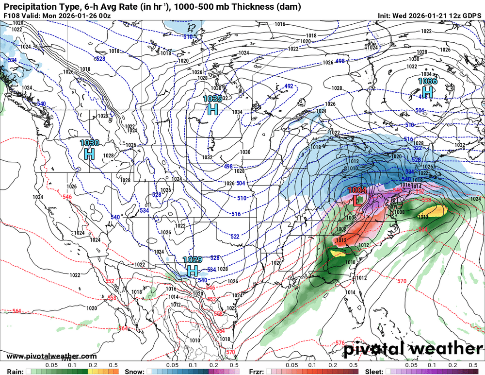
that's the 06z
We've stopped the north trend and will tick enough south to get that unwanted ice storm yet. I think better data gets into the models this evening, usually doesn't change much, but maybe tonight's 0z runs will give us something to hold on toCMC a tick south but might just be a tick slower...either way, take any south tick we can get
View attachment 186952
Still at least 48 hours for changes . Wouldn't wrote anything off at this point
Its gonna be there due to the surface low track . Still have doubts its that strong with the massive CAD funneling down . Just have to wait and seewhat's causing that warm tongue that hangs over central Alabama for 24 hours straight? It doesn't budge at all, very strange to a layman when everything else is caught up in a westerly flow.
That looks like a big shift south! More flat and stronger high and more confluence.CMC a tick south but might just be a tick slower...either way, take any south tick we can get
View attachment 186952
Not writing anything off, not sure how you got that from my post, but fact is Rah NWS relies heavily on the NBM (it's literally in their AFD). So with the latest trends on that, they will start to change their thoughts and p-types most likely. That's what I was saying.Still at least 48 hours for changes . Wouldn't wrote anything off at this point
Wow. Talk about a powerful push of southerly wind fighting the CAD into Ga. 30+ wind gust out of the SOUTH below Macon. What a battle of airmasses. If one is hoping to scour out the CAD...View attachment 186948Another big problem with amping this thing is the wind increase. Power line nightmare fuel.

Sent from my iPhone using Tapatalk
 being spewed in here currently
Idk who this cat is, or if he’s credible but it makes sense. Also, it’s more uplifting than the miserablebeing spewed in here currently
Sent from my iPhone using Tapatalk
Well that's a interesting post...if accurate he's basically inducing that GFS/GEM particularly have some early data ingestion that others may not have... It's interesting that RGEM/CMC both moved the Baja further SW in initial runs with new data if so move toward GFS is slightly

Well the CMC ain't exactly looking like that great based on surface analysis. Mixing line up to NYC lol.
CMC a tick south but might just be a tick slower...either way, take any south tick we can get
View attachment 186952

lol, even has a warm nose in Ala then
Stop looking at Surface charts. Read soundings, totally different story most times
Sent from my iPhone using Tapatalk
Idk who this cat is, or if he’s credible but it makes sense. Also, it’s more uplifting than the miserable
Sent from my iPhone using Tapatalk
Scratch that...just slower. You can see it more amped and it's almost congrats Chicago. I imagine by tomorrow Chicago to Cleveland will be the big snow winners.
View attachment 186961


