• Hello, please take a minute to check out our awesome content, contributed by the wonderful members of our community. We hope you'll add your own thoughts and opinions by making a free account!

Wintry Jan 23-27 Winter Storm Obs

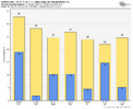
Final number at KRDU was 0.50" liquid equivalent and 0.6" SN/IP. Pretty brutal numbers considering all the hype leading up to it. I guess you should always take the driest model and chop off another 20-40% to get the real precip for a winter storm around here, unless it's rain in which case you'll get what is expected. Not a bad storm and higher impact than the number would suggest given the duration and coldness of the storm, but hardly a storm I will remember for long. Last February's storm overshadows it for me.

GSO was 0.80" liquid and 1.8" SN/IP.

Makes me feel dumb talking about the potentially historic nature of the storm last week to friends and family and comparing it to December 2002. đź’€
 
Final number at KRDU was 0.50" liquid equivalent and 0.6" SN/IP. Pretty brutal numbers considering all the hype leading up to it. I guess you should always take the driest model and chop off another 20-40% to get the real precip for a winter storm around here, unless it's rain in which case you'll get what is expected.

GSO was 0.80" and 1.8" SN/IP.
Qpf really dropped off as we got closer. My forecast was for 1" qpf for the Raleigh area. Bust!
 
Qpf really dropped off as we got closer. My forecast was for 1" qpf for the Raleigh area. Bust!
Yeah, I really though we'd get 1" of at least close to that. The fact we only came out to 0.50" is insane. It made it a pretty underwhelming storm since at least 1" liquid would've netted us 2" of sleet or something, which would've made this feel more memorable. I'll certainly take this over a major ice storm, but still.
 
Looking at precip analysis, the upstate got 1.2-1.5 of liquid for the event. Which was right in line with the drier AI models and much less than too wet icon/gfs kept showing. But also most of the hi-res models were too dry here in the day before the event until start time.

We only got 1.25 inches of sleet here but I think that was partly bc the sleet pellets were generally tiny. So sleet/liquid ratios may have been closer to 2:1 or worse. We got 3/8’s inch of ice, but I’d say that encompassed 1/2 inch or so of liquid equivalent since there was some run off when that heavy final band hit. (There was 0 runoff prior to that though).
 
Electric company basically said get ready to be without power multiple days at least! So we are hunkering down at a hotel and trying to possibly get a generator which is as hard as finding a hotel room last night.

9517e723f280ffc43ffe045ac892f9d7.jpg

7355a57167b444f181c074d4649f90d3.jpg

49787b1264bbd279545aa06719ab3d4f.jpg

c03e5984959e145685f2af208b41316d.jpg


Sent from my iPhone using Tapatalk
 
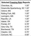
I’m not so sure. View attachment 189641
just feel like you would have seen damage reports from greenville if that were the case. it seems highly highly improbable to me that that is a correctly done measurement. maybe they included the branch, maybe it was flat accretion and they included some sleet in it. just seems erroneous to me considering every report around it
 
just feel like you would have seen damage reports from greenville if that were the case. it seems highly highly improbable to me that that is a correctly done measurement. maybe they included the branch, maybe it was flat accretion and they included some sleet in it. just seems erroneous to me considering every report around it
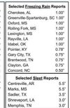
I think you’re right..this could have been Nashville IMG_8045.jpeg
 
just feel like you would have seen damage reports from greenville if that were the case. it seems highly highly improbable to me that that is a correctly done measurement. maybe they included the branch, maybe it was flat accretion and they included some sleet in it. just seems erroneous to me considering every report around it
Paris mountain probably/maybe got 1 inch of ice accretion and that’s where that’s coming from, imo. That elevation would have been ice for most of the storm I think.
 
I got about 1.5 inches of sleet. Not sure about ZR. Maybe .25 inches?

Really impressed with the wedge we got, it did work and kept me mostly sleet through the whole thing except half way through the front. Kids and me got to sled in the back open space near the woods, so it was great.

Nice little ice event, but of course no where near the qpf modeled I don't think. But I expected that considering where the storm was cutting, and mesos trending. Many at work are complaining it was a huge bust again, but I don't think it was. If we didn't stay sleet, it would have been a bad ice storm.

Last week was fun to track, but it was less fun when it turned into a straight Miller B on steroids.
 
I think you’re right..this could have been Nashville View attachment 189645
This was in the GSP chat this morning, Maybe that was the issue:

**NWS - Greenville-Spartanburg - Jake Wimberley [9:16 AM]
I forgot to post it here at the time, but we did a PNS yesterday evening more or less to include all the storm total sleet and freezing rain. There was an errant report of 1" freezing rain 3 SW Greenville-Spartanburg, which was supposed to be 1" sleet.**
 
Paris mountain probably/maybe got 1 inch of ice accretion and that’s where that’s coming from, imo. That elevation would have been ice for most of the storm I think.
My uncle's family near lives there with my grandma in Montebello. I wonder if they got it bad too.
 
I got about 1.5 inches of sleet. Not sure about ZR. Maybe .25 inches?

Really impressed with the wedge we got, it did work and kept me mostly sleet through the whole thing except half way through the front. Kids and me got to sled in the back open space near the woods, so it was great.

Nice little ice event, but of course no where near the qpf modeled I don't think. But I expected that considering where the storm was cutting, and mesos trending. Many at work are complaining it was a huge bust again, but I don't think it was. If we didn't stay sleet, it would have been a bad ice storm.

Last week was fun to track, but it was less fun when it turned into a straight Miller B on steroids.
Didn't get too lucky here in northeast Georgia, it was a lot of sleet until about Sunday morning where finally it gave up and transitioned to ZR. Currently in my 4th power outage right now, many trees down, and limbs snapped
 
Solid B+ storm just SW of Forest City. Very cold down to 18 at the peak of the storm. That's super rare CAD. Around a 1 inch of snow in the middle. More snow than anticipated. A quarter inch glaze of ice on everything and a couple inches of sleet in middle. Great storm but a nightmare to track but I will take it any way we can get them around here. Great storm and memories. On to this weekends storm.
 
This is easily the most devistating thing I ever saw. This place looks like a huge F5 tornado came through. I won’t have power for weeks. Luckily we still have water. I feel for people that don’t have gas heat . It’s suppose to be below zero tonight. I tried to upload a video but said it’s too big. I have very limited phone and internet service
 
This is easily the most devistating thing I ever saw. This place looks like a huge F5 tornado came through. I won’t have power for weeks. Luckily we still have water. I feel for people that don’t have gas heat . It’s suppose to be below zero tonight. I tried to upload a video but said it’s too big. I have very limited phone and internet service
Praying for you guys. I hope they can get in there and start to get things restored quickly.
 
This is easily the most devistating thing I ever saw. This place looks like a huge F5 tornado came through. I won’t have power for weeks. Luckily we still have water. I feel for people that don’t have gas heat . It’s suppose to be below zero tonight. I tried to upload a video but said it’s too big. I have very limited phone and internet service
So you guys need supplies? I’d be glad to Amazon some essentials your way. I’ll do what I can if it can help
 
Praying for you guys. I hope they can get in there and start to get things restored quickly.
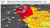
Thanks man. TVA got one of the main lines restored that comes into alcorn co. A few places in town got power restored tonight but it will be a long time for us county people. I meant to mention in my last post we receives 0.50 of sleet and an incredible 1.00 of ice. I would upload a lot of pics but internet is too slow.
 
So you guys need supplies? I’d be glad to Amazon some essentials your way. I’ll do what I can if it can help
Thanks man but I think we have most everything. I was pretty prepared what was to come. Don’t think it would be this bad tho. Now comes the clean up. I don’t even have a service poll or weatherhead on my house anymore.
 
2" Sleet and T ZR. 15 degrees at onset and under 20 for most of the duration of precipitation and I still couldn't get snow.

Convective sleet was something. With the hood to my carhart up, the cadence of the hydrometeors pelting me sounded like a the rain hitting the car in a summer storm. I was hoping for a clap of thunder for thundersleet, but it didn't happen.
 
36 degrees still snow everywhere

It's hard to believe that we were actually on the worst case scenario for snow here haha. The lowest amounts of any projection

I'm pretty sure some of it gonna make it to the front this weekend
 
  • Like
Reactions: SD
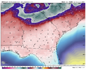
In the aftermath of the storm, the GFS was 100% on its own predicting on many runs from a few days out <0 F lows this morning (near or new all time record lows in some cases) stretching from NW GA through N and E ATL to Athens to GSP to CLT and into NC. Examples from the 0Z Thu 1/22 run (see image below) included Rome’s -7, Canton’s -5, Kennesaw’s/Lawrenceville’s -4, Gainesville’s -7 (vs -8 alltime coldest), Athens’ -8 (would be new alltime low) and Charlotte’s -9 (vs -5 alltime record cold)!

I was saying that the GFS was insane and that it has a severely cold bias for lows over wintry precip cover. All other models, including the often coldest Icon and CMC, were generally in the low to mid teens.

What verified?
Rome 14, Canton 10, Kennesaw 11, Lawrenceville 12, Gainesville 12, Athens 13, and Charlotte 14. So, this GFS was too cold by a ridiculous 15-23 for these cities while the other models were within just a few degrees.

I continue to strongly recommend that when the GFS is on its own with ridiculously hard to believe cold lows to ignore it. It’s worst over snowcover.

This is so laughable (GFS is so bad):
IMG_7426.png

@Wild Weather Monger
 
Back
Top