- Joined
- Jan 5, 2017
- Messages
- 3,806
- Reaction score
- 6,063
Yes, it appears it is. Looks like its near Tech Tower.Oh man. Is that at Ga Tech or other side of North Ave?
Yes, it appears it is. Looks like its near Tech Tower.Oh man. Is that at Ga Tech or other side of North Ave?
I have to admit, I'm slightly concerned now. It was one thing when precip totals were being cut, but that is a massive amount of moisture headed in as we are all below freezing.This is going to be a night to rememberView attachment 188838
I think I'm going to bottom out just above freezing, possibly around 34 degrees. My dewpoint is not dropping.I have to admit, I'm slightly concerned now. It was one thing when precip totals were being cut, but that is a massive amount of moisture headed in as we are all below freezing.
Pixie dust and sleet here in Concord.

I was like that for hours, then all of a sudden both dropped at the same time.I think I'm going to bottom out just above freezing, possibly around 34 degrees. My dewpoint is not dropping.
WebbIs this switch to snow due to the shattering effect Webb mentioned earlier or is it because it’s actually colder aloft?
I gotta hand it to our local NWS guys, they really kept their cool and stuck to their guns. The guys on TWC were all smug and kept saying it wasn't going to be much, and their building is ground zero for this plume about to roll through.DT Atlanta js about to get a legit ice storm IMO

Someone is waking up to .5"+ and its going to be funny when TWC is running on their generators tomorrow morning to broadcast.Man. We’re at 28.8 in South Forsyth and there’s a ton of moisture on the way. Absolute firehouseView attachment 188842
If my phone took pictures at a small enough resolution that was allowed to be uploaded to this site id show you icicles from NE ATLMan. We’re at 28.8 in South Forsyth and there’s a ton of moisture on the way. Absolute firehouseView attachment 188842

Not to take anything away from Atlanta and I won't flood this thread but it's actually impressive we've had a warning level snow event once it's all said and done with temps this coldView attachment 188844
Nah. Please continue. This thread is about to become increasingly depressing over the next 12 hours or so. We need more uplifting positive snowy pictures.
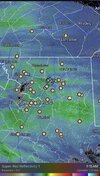
RadarScope actually has excellent documentation. Go to settings. And then help.How are you accessing that map?
Congratulations, Brent. Glad you got a nice snowstorm.Not to take anything away from Atlanta and I won't flood this thread but it's actually impressive we've had a warning level snow event once it's all said and done with temps this coldView attachment 188844
Like this.RadarScope actually has excellent documentation. Go to settings. And then help.
But if you tap top where radar name is. Under data sources, select composites. Then real time meso. You can prolly figure out from there.
And if you tap and hold bottom left where it says the name of the product viewing. You get a shortcut grid. Just like when viewing reflectivity. Can hit dewpoint. Freezing. Temps, etc. handy shortcut if RS users don’t already know about.

Dude, we love your posts. We are all living vicariously through your snowstorm!Not to take anything away from Atlanta and I won't flood this thread but it's actually impressive we've had a warning level snow event once it's all said and done with temps this coldView attachment 188844
Dude, we love your posts. We are all living vicariously through your snowstorm!

Yup! Thought maybe I had a shot at missing a bit longer. Smacked in the face with steady freezing rain. Radar looks.. concerning. Atlanta is toast.Before i go to bed, just want to remind everyone that just because the radar has “dry” spots on it out west (it’s feeling in nicely) as the surface low moves east it’ll really get the WAA kicking and fill in. It’s why we are randomly seeing it filling in now after we saturated the column. WAA over an extremely cold wedge is the recipe for moisture. Good luck everyone. I think we are going to need it