First possible board wide threat in forever or nah? In other words, do we RAGE or do we ditch Mitch?
Let'er rip and reel it in!
Let'er rip and reel it in!

2” for clt is the new 10”. Will be dancing in the street if we get it.It's going to snow.
I think the base is fine where it’s at. Now we’ve got to get it neutral where it’s at. Then we eatSlowing is fine, but don't want to see + tilt trend continue
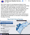
View attachment 183367
Good luck everybody!


Im with ya on the positive tilt continuing to worse. Could screw this whole thing up.
Last year it performed just as well on the big coastal right until 24 hoursidk man i cant ever remember the GFS defeating the euro at this time out
We have had this convo. AI models perform too warm on the surfaceI’m gonna say the euro is wrong with giving Tybee island, ga their 2nd 2+ inch event in the last two years. Especially when the ai models are raining on almost everybody.
That’s fine but it’s not just that. They both have way higher heights out ahead of the storm and much warmer mid levels as a result.We have had this convo. AI models perform too warm on the surface
It is interesting that SV picking up the UK as more snow than what Pivotal has...
View attachment 183377


I live near the upper portions of the precip last year, the flakes were small and wispy. Still managed to get 2 in, but it did not last longView attachment 183385
Final total map of GA 1/21 for that storm for comparison. It was too far NW with the northern edge of precip, dry air was too much if I remember correctly