Deep tropics
-
Hello, please take a minute to check out our awesome content, contributed by the wonderful members of our community. We hope you'll add your own thoughts and opinions by making a free account!
You are using an out of date browser. It may not display this or other websites correctly.
You should upgrade or use an alternative browser.
You should upgrade or use an alternative browser.
Tropical Invest 98L
- Thread starter SD
- Start date
Gonna be a big problem for someone
Stormsfury
Member
We're actually very close to a surface low cutting off very soon. Very strong southerly surge feeding into the Eastern side of 98L, into the very prominent mid level spin. The western Edge of 98L is where the surface is strongly trying to cut off
1. 12Z UKMET (goes to 168) maps once again have the low stay in the S Car and go west into Nicaragua; low is a bit stronger with it down to 1003 at strongest, which should easily be strong enough to be a TD although the textual output doesn’t show that:
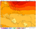
Will UK for 98L be a miserable fail, the big winner, or in between? Stay tuned!
————
2. 12Z JMA (goes to 192): has a cat 1 hurricane headed due west to just offshore the Nicaragua/Honduras border:
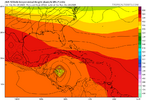

Will UK for 98L be a miserable fail, the big winner, or in between? Stay tuned!
————
2. 12Z JMA (goes to 192): has a cat 1 hurricane headed due west to just offshore the Nicaragua/Honduras border:

NCSNOW
Member
Avalanche
Member
0Z runs: all major ops are out
-Icon cat 2 H W. Haiti
-CMC first moves W and then WNW/NW to Jamaica as a TS followed by SW and then abrupt turn to N and then NNE/NE over C Cuba/NC Bahamas as a cat 3 H followed by a turn back to the N with it ending on a heading toward Cape Cod as it gets caught on the E side of a strong trough/upper low
-GFS very consistently hits Hispaniola again (cat 2 H)
-Euro just W of Jamaica, EC Cuba to C Bahamas (MH)
-UKMET remains quite consistent with the track and this time the text has it as a TC through hour 156, after which it weakens on approach to the NE Nicaraguan coast. The direction of movement starts off mainly WNW (with the furthest N being only at 15.3N) followed by W and then WSW; strongest it gets is a minimal TS and lowest SLP 1004. At hour 156, the 0Z UKMET is a whopping 1,500 miles WSW of the 0Z GFS!
TROPICAL STORM 98L ANALYSED POSITION : 11.1N 69.0W
ATCF IDENTIFIER : AL982025
LEAD CENTRAL MAXIMUM WIND
VERIFYING TIME TIME POSITION PRESSURE (MB) SPEED (KNOTS)
-------------- ---- -------- ------------- -------------
0000UTC 21.10.2025 0 11.1N 69.0W 1009 30
1200UTC 21.10.2025 12 14.0N 71.5W 1008 35
0000UTC 22.10.2025 24 14.0N 73.6W 1006 31
1200UTC 22.10.2025 36 14.2N 74.3W 1005 34
0000UTC 23.10.2025 48 15.3N 75.2W 1004 31
1200UTC 23.10.2025 60 15.3N 75.8W 1005 33
0000UTC 24.10.2025 72 15.3N 76.8W 1005 28
1200UTC 24.10.2025 84 15.3N 77.3W 1005 27
0000UTC 25.10.2025 96 14.7N 78.0W 1005 25
1200UTC 25.10.2025 108 14.6N 79.1W 1006 26
0000UTC 26.10.2025 120 14.2N 80.6W 1004 23
1200UTC 26.10.2025 132 14.4N 81.8W 1005 25
0000UTC 27.10.2025 144 13.9N 82.5W 1004 20
1200UTC 27.10.2025 156 14.1N 82.8W 1005 18
0000UTC 28.10.2025 168 CEASED TRACKING
Last edited:

