Shaggy
Member
The rollercoaster of tropical season.
Here's the rain map:You got any of them rain maps

The rollercoaster of tropical season.
Solid. Thank youHere's the rain map:View attachment 45573
So we have 6z GEFS west, 6z Euro west, 6z EPS west, 00z cmc west. Start of a long term trend?
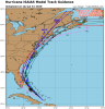
Nothing special.How about a wind map?
Sent from my iPhone using Tapatalk

Given it’s current appearance I think they have some credibility. What happens tonight into tomorrow morning With intensity will be huge with our impacts.These shifts are 100% due to Isaias's intensity in those models, a weaker storm goes further west into the Florida peninsula and extreme eastern Gulf, a stronger hurricane stays offshore.

Notice how much weaker this run is too. GFS likely still has a poleward/east bias here so take that with a grain of salt. Much of the eps shows Isaias at a similar intensity at that time but is much further SWView attachment 45576
6z GFS also took a good step SW
Agreed. The gefs shows the sw movementNotice how much weaker this run is too. GFS likely still has a poleward/east bias here so take that with a grain of salt. Much of the eps shows Isaias at a similar intensity at that time but is much further SW
NAM pops back out over water at 60 and strengthens. Might be getting some help being in the divergent part of the jet stream/trough.
Honestly this would probably more exciting for us central NC folks with regards to rain bands and even being on the tornado side of the storm
It drop to sub 1000 then weakened 3 hours later lol. Nam has super high pwats moving in my 66 hrs or so. Should be a wet period from that hour through the end of the run.The SSTs are around 86F in the gulf stream as well. I could see this pulling a Bertha as the shear will be less as he turns NNE.
Sent from my iPhone using Tapatalk
Honestly this would probably more exciting for us central NC folks with regards to rain bands and even being on the tornado side of the storm
It drop to sub 1000 then weakened 3 hours later lol. Nam has super high pwats moving in my 66 hrs or so. Should be a wet period from that hour through the end of the run.
I'm not sold on this being that strong tbh but anything could happen

Hurricane Watch up for portions of Florida's east coast.BULLETIN
Hurricane Isaias Advisory Number 14
NWS National Hurricane Center Miami FL AL092020
1100 AM EDT Fri Jul 31 2020
...HURRICANE WATCH ISSUED FOR PORTIONS OF THE FLORIDA EAST COAST...
...SQUALLY WEATHER OVER THE SOUTHEASTERN BAHAMAS AND THE TURKS AND
CAICOS ISLANDS SPREADING INTO THE CENTRAL BAHAMAS...
SUMMARY OF 1100 AM EDT...1500 UTC...INFORMATION
-----------------------------------------------
LOCATION...21.7N 74.5W
ABOUT 365 MI...585 KM SSE OF GREAT ABACO ISLAND
ABOUT 295 MI...470 KM SE OF NASSAU
MAXIMUM SUSTAINED WINDS...75 MPH...120 KM/H
PRESENT MOVEMENT...NW OR 305 DEGREES AT 16 MPH...26 KM/H
MINIMUM CENTRAL PRESSURE...992 MB...29.30 INCHES
WATCHES AND WARNINGS
--------------------
CHANGES WITH THIS ADVISORY:
A Hurricane Watch has been issued for portions of the Florida east
coast from north of Deerfield Beach northward to the
Volusia-Brevard County Line.
A Tropical Storm Warning has been issued for portions of the
Florida east coast from north of Ocean Reef northward to Sebastian
Inlet and for Lake Okeechobee.
The government of the Dominican Republic has discontinued the
Tropical Storm Warning for the Dominican Republic.
SUMMARY OF WATCHES AND WARNINGS IN EFFECT:
A Hurricane Warning is in effect for...
* Northwestern Bahamas including Andros Island, New Providence,
Eleuthera, Abacos Islands, Berry Islands, Grand Bahamas Island, and
Bimini
* Southeastern Bahamas including the Acklins, Crooked Island, Long
Cay, the Inaguas, Mayaguana, and the Ragged Islands
* Central Bahamas, including Cat Island, the Exumas, Long Island,
Rum Cay, and San Salvador
A Hurricane Watch is in effect for...
* North of Deerfield Beach to the Volusia-Brevard County Line
A Tropical Storm Warning is in effect for...
* Turks and Caicos Islands
* North of Ocean Reef northward to Sebastian Inlet
* Lake Okeechobee
Interests elsewhere along the southeast coast of the United States
should monitor the progress of Isaias. Additional watches or
warnings may be required later today.
A Hurricane Warning means that hurricane conditions are expected
somewhere within the warning area. Preparations to protect life
and property should be rushed to completion.
A Hurricane Watch means that hurricane conditions are possible
within the watch area. A watch is typically issued 48 hours
before the anticipated first occurrence of tropical-storm-force
winds, conditions that make outside preparations difficult or
dangerous.
A Tropical Storm Warning means that tropical storm conditions are
expected somewhere within the warning area within 36 hours.
For storm information specific to your area in the United
States, including possible inland watches and warnings, please
monitor products issued by your local National Weather Service
forecast office. For storm information specific to your area
outside of the United States, please monitor products issued by
your national meteorological service.