Snakey December. Snakes on the Plane December. Slithering Snape December. Ideas for next year.
-
Hello, please take a minute to check out our awesome content, contributed by the wonderful members of our community. We hope you'll add your own thoughts and opinions by making a free account!
You are using an out of date browser. It may not display this or other websites correctly.
You should upgrade or use an alternative browser.
You should upgrade or use an alternative browser.
Pattern December to Remember
- Thread starter SD
- Start date
accu35
Member
Slippery snake skinSnakey December. Snakes on the Plane December. Slithering Snape December. Ideas for next year.
Avalanche
Member
It better be better December
D
Deleted member 1449
Guest
I’m going to bed on Dec 30 with the windows open. This was for sure a December to remember.
Dewpoint Dan
Member
Too hot to have the windows open.I’m going to bed on Dec 30 with the windows open. This was for sure a December to remember.
This wx is reminds me of NYE 1987, could have neen 1988. Was a toasty one. We had warm winter wx stretches at severeal different times late 80s. Exception the early Jan 1988 storm
As of today, DFW has an average low of 50*F for the month of December.
Unfortunately, this morning low dipped down to 49*F. So the average will also dip back down ever so slightly. NYE's low will ultimately determine whether the average low ends up at/above 50*F or below.
Correction: The low on 12/30 was actually 48*F
The low this morning at DFW was 52*F, which (if it holds) will be *JUST* good enough for exactly a 50*F average low for the month of December.
Currently, after yesterday's "cool" morning of 48*F, the average low is officially at 49.9*F
Currently, after yesterday's "cool" morning of 48*F, the average low is officially at 49.9*F
Last edited:
Only 59 here today, setting the stage for upcoming winter storm ?
SC quakes

 apnews.com

2 more earthquakes shake South Carolina's Midlands region
ELGIN, S.C. (AP) — Two more earthquakes have struck near Columbia, South Carolina, where seven quakes have been felt since Monday.
Really? Wow 75 hereOnly 59 here today, setting the stage for upcoming winter storm ?
Yeah I was surprised too, never broke out of the cloudsReally? Wow 75 here
And actually only 55 at the airport
The great divide!!
And it's pouring to end 21
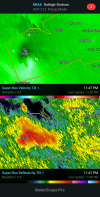
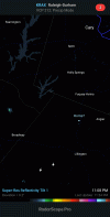
Just working into the area here. Snow within 10 days. Book it!Happy new year pretty awesome to have thunder and lightning right nowView attachment 100460
GarnerNC
Member
Saw some flashes in the sky a bit ago and assumed it was fireworks. Not sure if that will get up my way unfortunately.Happy new year pretty awesome to have thunder and lightning right nowView attachment 100460
Avalanche
Member
Looked down south of here and sure enough, storms.Saw some flashes in the sky a bit ago and assumed it was fireworks. Not sure if that will get up my way unfortunately.
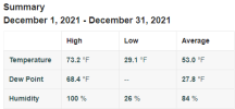
Min: 25.2
Max: 74.7
Avg: 49.8
Precip: 1.87
Max: 74.7
Avg: 49.8
Precip: 1.87
Min 25.7
Max 77.4
Avg 50.7
Rain 3.39
Snow 0.00
Max 77.4
Avg 50.7
Rain 3.39
Snow 0.00
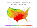
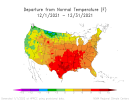
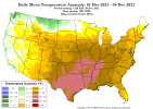
So needless to say, 2021 was the warmest December on record for DFW.
But just to show how unprecedented it was:
*1st December ever to end with a monthly average greater than 60°F (61.3°F to be exact).
*Previous record for warmest December was shattered by a whopping +7.3 degrees.
*1st December ever to end with a positive double-digit departure from average (+13.2 degrees to be exact).
*1st December ever to end with an average high greater than 70°F (72.6°F to be exact).
*The previous record for highest December average high was shattered by a whopping +6.7 degrees.
*1st December ever to end with an average low of at least 50°F (50°F to beexact).
*Previous record for highest December average low was shattered by a whopping +6.6 degrees.
*Grand total of only 1 freeze (with a low of only 32°F to be exact)
*Grand total of only 1 day with a sub-50°F high (48°F to be exact).
*Total of 23 days (yes, you read that correctly) with a high of 70°F+
*Total of 8 days with a high of 80°F+
*Warmest Christmas day on record, with a high of 82°F (breaking the previous record of 80°F from 2016).
*Ended with a 9-day consecutive streak of 70°F+ highs.
This was all driven by a number of combined factors, including widespread moderate/severe drought conditions across the Southern Plains, an unusually deep -PNA (deepest in at least 16 years), and the MJO which only slowly progressed through two phases (6 & 7) that were favorable for warmer than normal tempertures in Texas.
Last edited:
L
Logan Is An Idiot 02
Guest
Was this a top 3 warmest December for CLT?
Sent from my iPhone using Tapatalk
Sent from my iPhone using Tapatalk
Was this a top 3 warmest December for CLT?
Sent from my iPhone using Tapatalk
It was #3 with only 2015 and 1889 warmer. Kudos! Dec was 3.8 warmer than Nov, the largest warming Nov to Dec on record. That largest warming was also the case at RDU and SAV. ATL and RDU also had the 3rd warmest Dec with SAV 4th.
We’re now setting ourselves up for possibly one of the biggest coolings from Dec to Jan with the help of a large PNA rise from near record -PNA Dec and a move toward perhaps 8-1-2 low amp MJO. What would make that even more likely is if we could get -AO and/or -NAO to return.
Last edited:
Yes sir it was… great job calling that early. Obviously these last several days of not dropping below 60 at night had a huge impact on it.Was this a top 3 warmest December for CLT?
Sent from my iPhone using Tapatalk
L
Logan Is An Idiot 02
Guest
Yes sir it was… great job calling that early. Obviously these last several days of not dropping below 60 at night had a huge impact on it.
Thank you! Yes that did have a huge impact. March will deliver.
Sent from my iPhone using Tapatalk
It is now official per NCEP as expected: the December of 2021 -PNA is a December record going back to 1950, easily beating 1955. Also, the drop in PNA from Nov to Dec is easily a record.
Was it a record -PNA for ANY month? Not quite as Sep of 1986, April of 1954, and May of 1964 beat it. So, December of 2021 comes in as the 4th most negative PNA of the 864 months since January of 1950 and THE most negative for any winter month:
So, if one were wondering if it were really as ugly as it seemed on day after day after day of model runs last month, this sort of confirms that it was about as bad as ever.
Edited twice for correction
Last edited:

