• Hello, please take a minute to check out our awesome content, contributed by the wonderful members of our community. We hope you'll add your own thoughts and opinions by making a free account!

Pattern December Doldrums 2025 🎄 ❄️

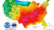
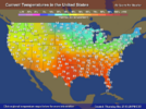
Which avg Conus Christmas highs were warmer, 2021 or 2025?

1. Based on geographic area, I’d say 2025. Why? Because most of the W 1/2 including most of the Plains states as well as MO and much of TX were warmer in addition to much of the SE. The NE to Ohio Valley to much of Midwest and much of the Midsouth was cooler.

2. In terms of population weighted highs (energy usage indicator), it’s a tougher call. I lean toward 2021 being net warmer because of the high population of the NE to Ohio Valley to Midwest.

2021 forecasted highs:
IMG_6491.jpeg

2025 3:20PM EST temperatures:
IMG_6493.png
 
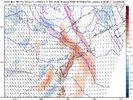
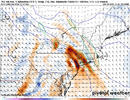
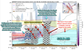
Super cool to see this dual mid-level frontogen structure on the models for this storm in the NE US.

nam3km_temp_adv_fgen_700_neus_20.png

700tadv.us_ne.png


Makes sense to me why this happening. You have 2 areas of heavier snowfall rates favored here with this one. One to the south likely just north of NYC on the leading edge of the warm nose aloft, where melting snow partially offsets the advancing warm advection. The other area is to the north over New England where the sloped warm advection aloft intersects the snow growth zone.

For most of us, even our best warm advection storms are typically stuck in the more southern regime where we're riding the edge of the warm nose and feeding off the enhanced FGEN from it. Oftentimes, there's not enough deep-layer cold air down here for warm advection to properly intersect the snow growth zone.

In any case, thought this was a cool thing to share.


Screenshot 2025-12-26 at 8.09.24 AM.png
 
Folks, please wish me luck as I’m about to take a walk smack dab in the middle of a torch! It’s now 75.2 here. I’m armed with my shorts, short sleeve shirt, and ice water. I think I’ll be able to handle the intense heat ok.
The last 4 days have been 73, 78, 77, 75 here !
 
Congratulations to these stations on their warmest "Christmas week" (12/20-12/26) by avg max temp on record --

-KGSP: 1st warmest by max (64.3, +10.8), T-2nd warmest by mean (51.6, +8.0)
-KATL: 1st warmest by max (67.4, +12.6), 2nd warmest by mean (58.1, +12.0)
-KTRI (Bristol, TN): 1st warmest by max (62.9, +14.9), 3rd warmest by mean (49.1, +11.0)
-KCHA: 1st warmest by max (66.1, +14.4), 3rd warmest by mean (55.3, +12.2)
-KMCN: 1st warmest by max (72.9, +12.9), 4th warmest by mean (56.7, +8.2)
-KMOB: 1st warmest by max (75, +12.7), 6th warmest by mean (63.4, +11.2)


some stations I checked that did not have a 1st or T-1st in either category but did have top 3 in both: KBHM, KAVL, KHSV
 
I like it when we get so late in a month where the current month thread dies because all the interesting stuff is in next month

Anyways, today feels the warmest of any day yet to me for some reason. 68 already. Our last chance to match the 77 of Christmas Eve before we wedge tomorrow and front Monday
 
CAD is always interesting to experience. I went skiing at Winterplace on Tuesday. The weather was pretty crappy for skiing (upper 40s and it had rained earlier in the day), but it was still a lot of fun since it wasn’t busy. On the way back, it warmed up to about 60 in southwest VA, but then once I came off the mountains down into Mt Airy it dropped from about 60 in Galax to 46 in Mt Airy!
 
I’ve been quite curious about what phases the MJO would be in during the heart of the widespread historic US warmth of late Dec, Dec 23-27. We needed to wait due to several days of reporting lag. Would any of it be in the typically chilly in the E 1/2 of the US phase 8?

Well, now we have the answer for the first 3 days, Dec 23-25: not surprisingly, none of those first 3 days were in phase 8. It turns out that Dec 23-4 were in very weak phase 7 while Dec 25 was in very weak phase 6, which I consider intuitive:


2025 12 23 -0.28945175 0.37228486 7 0.47157007 Gottschalk10_method:_OLR_&_ACCESS_wind
2025 12 24 -0.12800699 0.45807526 7 0.47562456 Gottschalk10_method:_OLR_&_ACCESS_wind
2025 12 25 0.16766728 0.36077648 6 0.39783412 Gottschalk10_method:_OLR_&_ACCESS_wind

IMG_6559.gif

Based on a combo of the above diagram and a related adjustment to the model prog consensus, I’m predicting that Dec 26th will be in very weak 4 and Dec 27th will be in either weak 3 or weak 2.

Will we get back into phase 8 before the end of Dec? The GEFS, JMA, and CFS with my adjustments suggest likely not whereas the adjusted Euro suggests there’s a chance for at least one day of weak 8 then.

Will we get back into phase 8 in early Jan? As of now there’s a moderate chance of mainly a weak 8, but that’s all I can say right now due to model disagreement and it being too far out for a confident prediction.
 
Back
Top