• Hello, please take a minute to check out our awesome content, contributed by the wonderful members of our community. We hope you'll add your own thoughts and opinions by making a free account!

Pattern December Doldrums 2025 🎄 ❄️

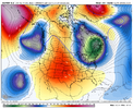
Wonder if we see 1 more episode of NATL blocking/-NAO, blocking over Scandinavia/urals showing up which is more then often a hint at a -NAO episode View attachment 178737
Yes and the updated looks show both the AO and NAO making another run to negative just after this time frame. One thing that keeps showing up is a cold Canada, so the cold is nearby
 
Peak climo for snow is late January… so at least we’re getting this awful mess out of the way in December. It won’t last forever.

Yeah, big picture it's not a big deal. December in my mind is house money as I usually don't expect too much so I can't be too disappointed. But we had a cool/cold period where we struck out because it just wasn't cold enough so thems the breaks in CLT. It's a weenie bummer.

But getting this torch period out of the way now and potentially getting something better 1st or 2nd week of January would be perfect if we could get it. Props to @GaWx for the mjo actual post. That kinda explains why the models look trash water upcoming, the pacific helped us for like a week. Hopefully it comes back out in 8, or quickly makes another run through 6-7-8, as I'm a big believer that the tropical convection, mjo, drives our pacific pattern more times that not.
 
The good news is it can’t any worse than what the 12z GFS operational showed at the end of the run. So we’ve got that going for us 👍🏽 View attachment 178747
Hey, in other good news, we still have the cold anomalies on our side of the globe! Just swing that scandi ridge into Greenland as Webb mentioned, and voila, back in blue!
 
The good news is it can’t any worse than what the 12z GFS operational showed at the end of the run. So we’ve got that going for us 👍🏽 View attachment 178747

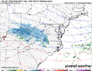
The bad news is that it can be much worse than this for Boxing Day: this probably belongs in banter though since it’s a 360 op panel.
IMG_6063.png
 
12z Euro has a continuation of "normal" late fall/early winter weather for Atlanta. Cold front passes through, gets cold at night, mid fifties to low sixties for highs after a cold day, then possible line of showers/rain, before the next cold front. Basically has this pattern through Christmas week. Depending on the timing of each cold front, Christmas day could be mild (60's?) or cold (40's). Right now, it has the warmth and rain on Christmas day followed by cold on the 26th.
 
If the -NAO was there around Christmas, I’d be willing to bite right now on some colder outcomes potentially getting thrown into the mix.

Sure, maybe we can sneak a colder day or two in there depending on how the waves setup, but this looks like a mild pattern to me atm.

Unfortunately, the Aleutian & Scandinavian ridges are really working against the SE US
 
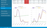
Natural gas is down another 8% today and is now down a whopping 23% vs the high of one week ago! Here’s the ugly wx reason though it’s great news for future energy bills for the time being (actually NG marketers have lots of storage to draw from and thus the retail prices don’t vary nearly as sharply as one might think; also there are state price utility commission controls in some states): look on the left and that steep dive in EPS HDDs that flatline way below normal near 15/day for the purple 0Z run (today’s 12Z run wasn’t out yet on this…I think it came back slightly then to 16ish/day, which would be near the yellow line of yesterday’s 12Z):
IMG_6064.png
 
bb8057252fb1c058993d80a53808f86b.jpg

0b279fbeb00c9bc26edd87a2fb136103.jpg

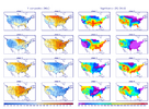
Both ensembles going for a neutral or slightly -NAO after Christmas.


Sent from my iPhone using Tapatalk
 
Back
Top