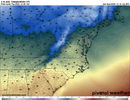
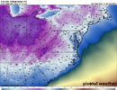
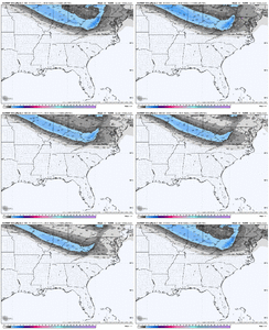
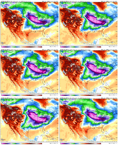
won't be sustained enough to techinically qualify as a blizzard, but winds will be gusting past 40-50mph for many in the high country this evening. with snow already on the ground up there, visibility will be very poor and drifting will occur. a far cry from the almost perfectly still straight-down snowfall of monday up there. i think you'll find a handful of 4-7" reports at the high peaks & ski resorts with this oneView attachment 178692
View attachment 178693
View attachment 178694Snow squalls look mighty this afternoon into evening. NC mountains will get a nice period of snow in the early morning hours.
-
Hello, please take a minute to check out our awesome content, contributed by the wonderful members of our community. We hope you'll add your own thoughts and opinions by making a free account!
You are using an out of date browser. It may not display this or other websites correctly.
You should upgrade or use an alternative browser.
You should upgrade or use an alternative browser.
Pattern December Doldrums 2025 🎄 ❄️
- Thread starter SD
- Start date
Tsappfrog20
Member
Thanks for that info. Do you know how long “freezing fog advisories” have existed at CHS, at Mobile, or at any NWS office for that matter?
Having lived in Charleston for 8 years y’all just sent me on a search of Snowstorms in Charleston! It has been awesome to remember the 2010 snow when I worked at the TV Station with the Weather Team!
Sent from my iPhone using Tapatalk
It got down to 29 at KSAV for the low this morning, which was a few degrees colder than the forecasted lower 30s. But it didn’t quite get down to the coldest yet this season, which is the incredible 28 of Nov 11th.
mby has just hit 50F for the first time since 11/27. we were close to a top 10 recorded streak at or below 50F at KGSP. it did just barely crack the top 10 at KSPA (more mby than GSP)
mby has just hit 50F for the first time since 11/27. we were close to a top 10 recorded streak at or below 50F at KGSP
Do you know what and when was the record longest on record 50 or below streak for KGSP for late Nov into early Dec?
not sure, but i can tell you that the past 2 weeks are the 2nd coldest 11/26-12/9 on record at KGSP going by max temperature, with an average of 47.7F, which is 10.0F below average for that stretch. going by average temp, T-10th coldest 11/26-12/9 (40.3F, 7.0F below avg).Do you know what and when was the record longest on record 50 or below streak for KGSP for late Nov into early Dec?
our lows have not been breathtaking. most nights have been low-mid 30s, which is chilly, but not crazy. we're -7.7F for dec overall to date
This is the typical scenario for most winters in the Southeast. Rarely do we get locked into a long term (two weeks or more) above normal or below normal temperature pattern. I guess we will just have take the slow ride to the top of the temperature roller coaster after this week through Christmas and after that we should be coming down again with, hopefully, some chances for winter precipitation around New Year'sThink your gonna get back and forth first 2/3rds of winter. Rythym will flip every 10-12 days max between EC Trough/WC Ridge & Vice Versa. latest CFS shows this. We have had our stretch of EC trough/WC Ridge for 20 days if you go back into late November , as it will subside by 12/16 and they will flip. By 12/27 looks like we will have flipped back, ride it until 1/8ish and then flip back again.
Day. Didn't one of the models just the other day advertise a massive ice storm around that period?
Should be a fun rest of day into night up here where I'm at. Wish I could share the wealth with everyone. Beech Mountain has some good live cams if you wanted to check them out later. It's sunny and 34 degrees right now.
Prestige Worldwide
Member
NCHighCountryWX
Member
- Joined
- Dec 28, 2016
- Messages
- 699
- Reaction score
- 1,918
Get out an enjoy the snow tomorrow if you can get the time off. It may be quite a while before more comes down this winter.
NCHighCountryWX
Member
- Joined
- Dec 28, 2016
- Messages
- 699
- Reaction score
- 1,918
True winter has now revealed it's hand this week. It seems to happen every year around 10 days into December.
Up where your at, Id bet house money it will snow at least 2 more times before the new year rings in, despite the 12/15-12/25 garbage look on models. Im talking the 1-3 upslope variety. To many NS mini vorts. They cant dig and amplify for us, But you and central Apps have been the bullseye for the ole jet stream.Get out an enjoy the snow tomorrow if you can get the time off. It may be quite a while before more comes down this winter.
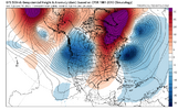
What a block! Why can't we ever get this in the near term? We'll see what the ensembles say in a bit, but the atmosphere has wanted to be rather blocky through the fall, so something like this wouldn't surprise me if it eventually showed up. Hopefully, when it does, we can get rid of the barftastic Pacific.

Tsappfrog20
Member
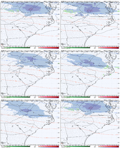
I wonder how much more we can tick this clipper South for you NC & Eastern TN folks.
View attachment 178698
Keep on coming lol
Sent from my iPhone using Tapatalk
WolfpackHomer91
Member
Just enough to show the Northern CLT Metro Dusting - 1" Then give Lynchburg 5-7" last minuteI wonder how much more we can tick this clipper South for you NC & Eastern TN folks.
View attachment 178698
Man we got to get Charlotte some snow before NBAcentral myfrotho changes his hobby. Bro come back to us.Just enough to show the Northern CLT Metro Dusting - 1" Then give Lynchburg 5-7" last minute
WolfpackHomer91
Member
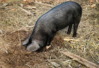
Maybe that phrase is outdated, stereotypical and offensive to pigs.
We should use appropriate words like "Dig like mole."
GSO has hit 50 per my phone. Streak has ended. Funny thing is, even with sun, it feels as cold as yesterday cause of the gale force winds outside lol.
Raleigh NWS has a 20% chance of snow in the grids here for Friday.
Raleigh NWS has a 20% chance of snow in the grids here for Friday.
Tsappfrog20
Member

Lol this is funny!!
Sent from my iPhone using Tapatalk
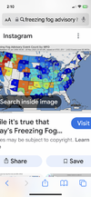
This is the 2nd time the Charleston WFO has issued a freezing fog advisory, the first being February 9, 2022
I just found this map of the number of freezing fog advisories issued by each NWS office since 1/1/2006. This is as of 11/20/25. So, it excludes the ones just issued by Mobile and CHS. This shows that the one just issued by CHS was only the 2nd in 20 years. Pittsburgh just issued their first ever on Nov 20th. Also, three offices in NC had issued only one through then and CAE only two since 2006:
Drizzle Snizzle
Member
it was 25 here this morningIt got down to 29 at KSAV for the low this morning, which was a few degrees colder than the forecasted lower 30s. But it didn’t quite get down to the coldest yet this season, which is the incredible 28 of Nov 11th.
I can't wait to add the GFS/AI to the current models in use. I wonder when it will be added to the model suite that comes with my Pivotal subscription.
I can't wait to add the GFS/AI to the current models in use. I wonder when it will be added to the model suite that comes with my Pivotal subscription.
it's already available here: https://nomads.ncep.noaa.gov/ at the bottom. so if they aren't providing it, they could have been already
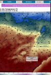
always too much fantasy land watching in the wx community. This is looking like the coldest airmass yetWe have been so focused on the warm possibly coming that a trend South to much colder temperatures with this Arctic airmass slipped a bit under the radar. Especially after losing it an earlier this week. Looks frigid early next week. View attachment 178704
nbm has cae in the low 20s with apparent temps of lower teens, definitely gonna be cold. then we rebound to the mid to upper 60s after as we head towards christmas, on some of the members
- Joined
- Jan 2, 2017
- Messages
- 1,566
- Reaction score
- 4,279
That is good to see. 21 would be pretty chilly for December but I remember 2022 Christmas eve was in the single digits here..like 5..that was memorable!We have been so focused on the warm possibly coming that a trend South to much colder temperatures with this Arctic airmass slipped a bit under the radar. Especially after losing it a earlier this week. Looks frigid early next week. View attachment 178704
- Joined
- Jan 2, 2017
- Messages
- 1,566
- Reaction score
- 4,279
JHS
Member
It looks like Pivotal already has some version of it. Probably not what NOAA will be using though.I can't wait to add the GFS/AI to the current models in use. I wonder when it will be added to the model suite that comes with my Pivotal subscription.
Picked a great weekend to go camping. Might need to light a fire under the gray water tank to empty it Monday morning. 
Also had some wacky freezing frost evaporating once the sun came out and started heating up the grass. Wouldn't call it fog because there was none before. Had a crazy amount of ice accrete on the commute this morning because of it.
Also had some wacky freezing frost evaporating once the sun came out and started heating up the grass. Wouldn't call it fog because there was none before. Had a crazy amount of ice accrete on the commute this morning because of it.
Yesterday, I had a high of 32 degrees. Cloudy all day, but no moisture. Today, I've had a high of 51. And currently it's 46 and raining. You gotta love winter in the SE. 


Its going to be cool to see temps likely fall during the day Sunday
iGRXY
Member
Don’t worry, we will CAD the closer to the medium range you get at worst. You can already see it even on this lookWe will see how much this changes but as of today Christmas eve forecast on the euro is 65 for my
View attachment 178705

