15-30% outlined by spc
-
Hello, please take a minute to check out our awesome content, contributed by the wonderful members of our community. We hope you'll add your own thoughts and opinions by making a free account!
You are using an out of date browser. It may not display this or other websites correctly.
You should upgrade or use an alternative browser.
You should upgrade or use an alternative browser.
Severe 4/5-6 2025 Severe weather
- Thread starter SD
- Start date
JHS
Member
Much of AL and GA have a slight risk for Sunday that I think may get pulled north some.15-30% outlined by spc
It ain’t much but it’s an honest days work lol

Yep! Here's the discoIs this mostly a wins threat for ga?
...SUMMARY...
A wind-damage and isolated tornado threat will be likely on Sunday
across parts of the Southeast and southern Appalachians. Marginally
severe wind gusts will also be possible in parts of the southern
Appalachians, Carolinas, and Mid-Atlantic.
...Southeast/Southern Appalachians...
A mid-level trough will move slowly eastward across the central U.S.
on Sunday, as an associated cold front advances eastward across the
central Gulf Coast states and Tennessee Valley. Along and ahead of
the front, a large MCS will be ongoing at the start of the period.
This MCS will move eastward during the day. Ahead of the MCS,
warming surface temperatures across a very moist airmass, and
moderate deep-layer shear, will be favorable for isolated severe
storms. Forecast soundings Sunday afternoon in the central Gulf
Coast states near the instability axis have MLCAPE peaking in the
1000 to 1500 J/kg range with 0-6 km shear near 40 knots. In
addition, low-level lapse rates are forecast to steepen during the
day. This should be favorable for isolated severe storms. Supercell
development will be possible along or ahead of the line, mainly in
areas where instability becomes the strongest. Bowing line segments
will also be possible within the line itself. The primary threat is
expected to be wind damage, but an isolated tornado threat will also
be possible. The greatest severe potential appears likely to shift
eastward from the central Gulf Coast states into Georgia and the
eastern Florida Panhandle by early evening.
Frozen Thunderstorm
Member
The largest threat coming this weekend is flooding. At least for me. We're helping pump two feet of water from this basement near Nashville. Water is threatening the electrical pump that feeds the 17-floor building. Rivers are still extremely aggravated from the rain.
View attachment IMG_4082.jpg
View attachment IMG_4082.jpg
Belle Lechat
Member
- Joined
- Aug 29, 2021
- Messages
- 1,529
- Reaction score
- 1,215
411 AM CDT SAT APR 5 2025
THE NATIONAL WEATHER SERVICE IN MEMPHIS HAS ISSUED A
* TORNADO WARNING FOR...
CENTRAL WEAKLEY COUNTY IN WEST TENNESSEE...
NORTHWESTERN GIBSON COUNTY IN WEST TENNESSEE...
SOUTHEASTERN OBION COUNTY IN WEST TENNESSEE...
* UNTIL 500 AM CDT.
* AT 411 AM CDT, A SEVERE THUNDERSTORM CAPABLE OF PRODUCING A TORNADO
WAS LOCATED NEAR EATON, OR 7 MILES WEST OF TRENTON, MOVING
NORTHEAST AT 45 MPH.
HAZARD...TORNADO.
SOURCE...RADAR INDICATED ROTATION.
IMPACT...FLYING DEBRIS WILL BE DANGEROUS TO THOSE CAUGHT WITHOUT
SHELTER. MOBILE HOMES WILL BE DAMAGED OR DESTROYED.
DAMAGE TO ROOFS, WINDOWS, AND VEHICLES WILL OCCUR. TREE
DAMAGE IS LIKELY.
* LOCATIONS IMPACTED INCLUDE...
SANDHILL, MASON HALL, DYER, GRIZZARD, DRESDEN, BRADFORD, MOUNT
PELIA, GOOD LUCK, CENTRAL, SHARON, RALSTON, RUTHERFORD, CURRIE,
BRAZIL, BARRONS CORNER, TYSON STORE, GEORGETOWN, LANEVIEW, KENTON,
AND SIDONIA.
Belle Lechat
Member
- Joined
- Aug 29, 2021
- Messages
- 1,529
- Reaction score
- 1,215


Belle Lechat
Member
- Joined
- Aug 29, 2021
- Messages
- 1,529
- Reaction score
- 1,215
427 AM CDT SAT APR 5 2025
THE NATIONAL WEATHER SERVICE IN MEMPHIS HAS ISSUED A
* TORNADO WARNING FOR...
SOUTHEASTERN WEAKLEY COUNTY IN WEST TENNESSEE...
NORTHEASTERN GIBSON COUNTY IN WEST TENNESSEE...
NORTHWESTERN CARROLL COUNTY IN WEST TENNESSEE...
SOUTHWESTERN HENRY COUNTY IN WEST TENNESSEE...
* UNTIL 515 AM CDT.
* AT 427 AM CDT, A SEVERE THUNDERSTORM CAPABLE OF PRODUCING A TORNADO
WAS LOCATED OVER BRADFORD, OR 8 MILES NORTHEAST OF TRENTON, MOVING
NORTHEAST AT 35 MPH.
HAZARD...TORNADO.
SOURCE...RADAR INDICATED ROTATION.
* LOCATIONS IMPACTED INCLUDE...
SANDHILL, TUCKERS CORNER, BRADFORD, GOOD LUCK, CADES, COMO,
STAFFORDS STORE, VAUGHNS GROVE, MCKENZIE, BARRONS CORNER, GANN,
HENRY, WINGO, LANEVIEW, JARRELL, HICO, GREENFIELD, SKULLBONE,
GLEASON, AND HINKLEDALE.
NWMSGuy
Member
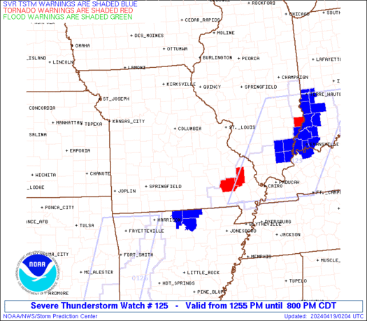
Moderate Risk just issued here and 5th Tornado Watch since Wednesday.
What a bow! Many trees are going to be on the ground by sunset. Winds off the deck close to 80 mph!


BufordWX
Member
Warned for up to 90 MPH wind gusts…
GeorgiaGirl
Member
Warned for up to 90 MPH wind gusts…View attachment 172361
Basically a PDS Severe Thunderstorm Warning, a first for me in seeing something like that, oof.
Edit: Although I just took 30 seconds to look and figured out I'm out of the loop. They can issue these for strong wind gusts.
90 MPH. Oof. That's rough.Warned for up to 90 MPH wind gusts…View attachment 172361
BufordWX
Member
Flash Flood Emergency for Memphis.
What a bow! Many trees are going to be on the ground by sunset. Winds off the deck close to 80 mph!
View attachment 172356
View attachment 172355
That part of Arkansas almost resembles the Great Plains for lack of trees. Still quite a few around but nothing like the east coast.
Ah ok, didn't realize that. That's good, cause there would definitely be a lack of trees after this event.That part of Arkansas almost resembles the Great Plains for lack of trees. Still quite a few around but nothing like the east coast.
Mahomeless
Member
Nothingburger for supercells so far….seems like we skipped Dixie Alley severe season.
BufordWX
Member
Getting rough in Nashville right now.
Dang. Another one. Same areas
BufordWX
Member
Frozen Thunderstorm
Member
Getting rough in Nashville right now.
We just had a very scary Tornado Warning. Observed Torrential Rains and 50-70MPH Winds around Hermitage (Eastern Nashville Suburbs). We had a 5-minute outage that caught me off guard as I was playing Monster Hunter Wild with the 'Boys'. Couldn't hear a thing, and couldn't see s##T outside. It was like the blinding rain that Floridians experience. Couldn't see more than 30 feet, and winds were whipping around. The Rivers in Mt. Juliet will be raging later on tonight.
BNA Airport had a 67MPH Wind Gust.

WoW. Just saw this forecast.

Last edited:
Belle Lechat
Member
- Joined
- Aug 29, 2021
- Messages
- 1,529
- Reaction score
- 1,215
545 PM CDT SAT APR 5 2025
THE NATIONAL WEATHER SERVICE IN LOUISVILLE HAS ISSUED A
* TORNADO WARNING FOR...
MONROE COUNTY IN SOUTH CENTRAL KENTUCKY...
SOUTHEASTERN ALLEN COUNTY IN SOUTH CENTRAL KENTUCKY...
CUMBERLAND COUNTY IN SOUTH CENTRAL KENTUCKY...
SOUTHEASTERN METCALFE COUNTY IN SOUTH CENTRAL KENTUCKY...
* UNTIL 630 PM CDT.
* AT 544 PM CDT, A SEVERE THUNDERSTORM CAPABLE OF PRODUCING A TORNADO
WAS LOCATED NEAR LAFAYETTE, MOVING NORTHEAST AT 65 MPH.
HAZARD...TORNADO.
SOURCE...RADAR INDICATED ROTATION.
* THIS DANGEROUS STORM WILL BE NEAR...
TOMPKINSVILLE AROUND 555 PM CDT.
BURKESVILLE AROUND 615 PM CDT.
OTHER LOCATIONS IMPACTED BY THIS TORNADIC THUNDERSTORM INCLUDE
LITTRELL, GUM TREE, BLYTHE, HARLAN CROSSROADS, ELLINGTON, GRIDER,
PEYTONSBURG, RAYDURE, EMBERTON, AND FOUNTAIN RUN.
Belle Lechat
Member
- Joined
- Aug 29, 2021
- Messages
- 1,529
- Reaction score
- 1,215
Belle Lechat
Member
- Joined
- Aug 29, 2021
- Messages
- 1,529
- Reaction score
- 1,215


30% of Davidson county (Nashville) is without power
18z HRRR has 8 inches of rain in 12 hours tomorrow near Atlanta 
Belle Lechat
Member
- Joined
- Aug 29, 2021
- Messages
- 1,529
- Reaction score
- 1,215
Central and Eastern Arkansas 72 hour rain totals
556 PM CDT SAT APR 5 2025
THE NATIONAL WEATHER SERVICE IN LITTLE ROCK HAS EXTENDED THE
* FLASH FLOOD WARNING FOR...
LONOKE COUNTY IN CENTRAL ARKANSAS...
NORTHWESTERN PRAIRIE COUNTY IN CENTRAL ARKANSAS...
WHITE COUNTY IN CENTRAL ARKANSAS...
SOUTHWESTERN JACKSON COUNTY IN EASTERN ARKANSAS...
* UNTIL 830 PM CDT.
* AT 556 PM CDT, DOPPLER RADAR AND AUTOMATED RAIN GAUGES INDICATED
THUNDERSTORMS PRODUCING HEAVY RAIN ACROSS THE WARNED AREA. BETWEEN
9 AND 15 INCHES OF RAIN HAVE FALLEN IN THE LAST 72 HOURS.
604 PM CDT SAT APR 5 2025
THE NATIONAL WEATHER SERVICE IN LITTLE ROCK HAS EXTENDED THE
* FLASH FLOOD WARNING FOR...
SOUTHEASTERN LONOKE COUNTY IN CENTRAL ARKANSAS...
PRAIRIE COUNTY IN CENTRAL ARKANSAS...
SOUTHEASTERN WHITE COUNTY IN CENTRAL ARKANSAS...
SOUTHEASTERN JACKSON COUNTY IN EASTERN ARKANSAS...
NORTHWESTERN MONROE COUNTY IN EASTERN ARKANSAS...
WOODRUFF COUNTY IN EASTERN ARKANSAS...
* UNTIL 900 PM CDT.
* AT 604 PM CDT, DOPPLER RADAR INDICATED THUNDERSTORMS PRODUCING
HEAVY RAIN ACROSS THE WARNED AREA. BETWEEN 8 AND 11 INCHES OF RAIN
HAVE FALLEN IN THE LAST 72 HOURS.
Belle Lechat
Member
- Joined
- Aug 29, 2021
- Messages
- 1,529
- Reaction score
- 1,215


BufordWX
Member
Intense looking storm in Northern MS.
Frozen Thunderstorm
Member
30% of Davidson county (Nashville) is without power
These people need to cut down the Trees near their power lines. I'm renovating the McKendree Tower in Hermitage, as well as the houses behind it. I had a Gardener, and my own guys, cut down the trees near the houses and power lines. People keep losing power around the area because they, or the landlord, don't maintain their properties. I posted a picture of the basement of the tower flooding on Thursday. I had to bring in a big water pump from KC, because the maintenance guys couldn't get the job done with the pumps they bought at Harbor Freight. I'm about to go check out the basement to see if it got worse. Need to let the new owner know about after the Sabbath ends.
BufordWX
Member
PDS warning on this now.Intense looking storm in Northern MS.View attachment 172372

NWMSGuy
Member
Ugly!Intense looking storm in Northern MS.View attachment 172372
NWMSGuy
Member
Well, I think my area is finally done after 4 days. 
Man. Didn’t expect to see a PDS warning there. Hope it falls apart before getting into NW Alabama
Tiniest moderate ever
Belle Lechat
Member
- Joined
- Aug 29, 2021
- Messages
- 1,529
- Reaction score
- 1,215
812 PM CDT SAT APR 5 2025
THE NATIONAL WEATHER SERVICE IN MEMPHIS HAS ISSUED A
* TORNADO WARNING FOR...
NORTHERN TISHOMINGO COUNTY IN NORTHEASTERN MISSISSIPPI...
NORTHERN PRENTISS COUNTY IN NORTHEASTERN MISSISSIPPI...
SOUTHEASTERN ALCORN COUNTY IN NORTHEASTERN MISSISSIPPI...
SOUTHEASTERN HARDIN COUNTY IN WEST TENNESSEE...
* UNTIL 900 PM CDT.
* AT 812 PM CDT, A CONFIRMED TORNADO WAS LOCATED OVER THRASHERS, OR
NEAR BOONEVILLE, MOVING NORTHEAST AT 50 MPH.
HAZARD...DAMAGING TORNADO.
SOURCE...LAW ENFORCEMENT CONFIRMED TORNADO.
* LOCATIONS IMPACTED INCLUDE...
BACON SPRINGS, IUKA, WALNUT GROVE, DOSKIE, J P COLEMAN STATE PARK,
PINEFLAT, BLYTHE CROSSING, POLLARDS MILL, RIENZI, BRUTON BRANCH,
BOONEVILLE, THRASHERS, GASTON, GLEN, HAZARD SWITCH, WALKER SIDING,
HOLCUT, BURNSVILLE, HOLTS SPUR, AND WINN SPRINGS.
PRECAUTIONARY/PREPAREDNESS ACTIONS...
TO REPEAT, A TORNADO IS ON THE GROUND.
Belle Lechat
Member
- Joined
- Aug 29, 2021
- Messages
- 1,529
- Reaction score
- 1,215
802 PM CDT SAT APR 5 2025
THE NATIONAL WEATHER SERVICE IN PADUCAH HAS EXTENDED THE
* FLASH FLOOD WARNING FOR...
CALLOWAY COUNTY IN WESTERN KENTUCKY...
FULTON COUNTY IN WESTERN KENTUCKY...
GRAVES COUNTY IN WESTERN KENTUCKY...
HICKMAN COUNTY IN WESTERN KENTUCKY...
LYON COUNTY IN WESTERN KENTUCKY...
MARSHALL COUNTY IN WESTERN KENTUCKY...
* UNTIL 800 AM CDT SUNDAY.
* AT 802 PM CDT, EMERGENCY MANAGEMENT REPORTED MODERATE TO HEAVY
RAIN ACROSS THE AREA. BETWEEN 5 AND 13 INCHES OF RAIN HAVE FALLEN.
ADDITIONAL RAINFALL AMOUNTS UP TO 1 INCH ARE POSSIBLE IN THE
WARNED AREA. FLASH FLOODING IS ALREADY OCCURRING.
HAZARD...LIFE THREATENING FLASH FLOODING. HEAVY RAIN PRODUCING
FLASH FLOODING.
SOURCE...EMERGENCY MANAGEMENT REPORTED.
IMPACT...LIFE THREATENING FLASH FLOODING OF CREEKS AND STREAMS,
URBAN AREAS, HIGHWAYS, STREETS AND UNDERPASSES.
* SOME LOCATIONS THAT WILL EXPERIENCE FLASH FLOODING INCLUDE...
MURRAY, MAYFIELD, BENTON, CALVERT CITY, EDDYVILLE, FULTON,
HICKMAN, CLINTON, HILLMAN FERRY CAMPGROUND, BIRMINGHAM FERRY
RECREATION AREA, DEMUMBERS BAY CAMPGROUND, LAND BETWEEN THE LAKES
AREA, CRAVENS BAY CAMPGROUND, SEDALIA, LYNNVILLE, FULGHAM, CAYCE,
KUTTAWA, WINGO AND HARDIN.
BOTH NORTHBOUND LANES OF I-69 HAVE BEEN CLOSED AT THE I-24
INTERCHANGE IN LYON COUNTY.
FLASH FLOOD...OBSERVED
FLASH FLOOD DAMAGE THREAT...CONSIDERABLE
Belle Lechat
Member
- Joined
- Aug 29, 2021
- Messages
- 1,529
- Reaction score
- 1,215
TORNADO WARNING MEMPHIS TN - KMEG 819 PM CDT SAT APR 5 2025
TORNADO WARNING MEMPHIS TN - KMEG 819 PM CDT SAT APR 5 2025
FLASH FLOOD WARNING LITTLE ROCK AR - KLZK 817 PM CDT SAT APR 5 2025
TORNADO WARNING NASHVILLE TN - KOHX 817 PM CDT SAT APR 5 2025
TORNADO WARNING MEMPHIS TN - KMEG 819 PM CDT SAT APR 5 2025
FLASH FLOOD WARNING LITTLE ROCK AR - KLZK 817 PM CDT SAT APR 5 2025
TORNADO WARNING NASHVILLE TN - KOHX 817 PM CDT SAT APR 5 2025
tennessee storm
Member
Same here man. What a stretchWell, I think my area is finally done after 4 days.