• Hello, please take a minute to check out our awesome content, contributed by the wonderful members of our community. We hope you'll add your own thoughts and opinions by making a free account!

Tropical 2026 Tropics Thread 🌀

literal peak of season and can’t buy a swirl. sad!!!

I kind of love it. I've always said I wondered what those really dead years back in the 80s were like

People have just been spoiled since 2016/2017 and even to a point back to 2004/2005. Very spoiled especially with all the Gulf landfalls

I kind of hope we don't even get a hurricane at this point haha let's go for history
 
Last edited:
What’s this on the 12Z UKMET? For the first time, it has a TC (TD) in the C Gulf late in the run with it moving slowly WNW and strengthening:

NEW TROPICAL CYCLONE FORECAST TO DEVELOP AFTER 150 HOURS
FORECAST POSITION AT T+150 : 25.0N 90.7W

LEAD CENTRAL MAXIMUM WIND
VERIFYING TIME TIME POSITION PRESSURE (MB) SPEED (KNOTS)
-------------- ---- -------- ------------- -------------
0000UTC 22.09.2026 156 25.0N 90.4W 1008 23
1200UTC 22.09.2026 168 25.5N 91.7W 1005 31
 
What’s this on the 12Z UKMET? For the first time, it has a TC (TD) in the C Gulf late in the run with it moving slowly WNW and strengthening:

NEW TROPICAL CYCLONE FORECAST TO DEVELOP AFTER 150 HOURS
FORECAST POSITION AT T+150 : 25.0N 90.7W

LEAD CENTRAL MAXIMUM WIND
VERIFYING TIME TIME POSITION PRESSURE (MB) SPEED (KNOTS)
-------------- ---- -------- ------------- -------------
0000UTC 22.09.2026 156 25.0N 90.4W 1008 23
1200UTC 22.09.2026 168 25.5N 91.7W 1005 31
Gfs continues to be sloppy over the western A, Caribbean and GOM. Seems.it wants to spit out something again but too much going on all over the place. Wonder if the ukmet is picking up on one of those possibilities now
 
s01e08 GIF
 
What’s this on the 12Z UKMET? For the first time, it has a TC (TD) in the C Gulf late in the run with it moving slowly WNW and strengthening:

NEW TROPICAL CYCLONE FORECAST TO DEVELOP AFTER 150 HOURS
FORECAST POSITION AT T+150 : 25.0N 90.7W

LEAD CENTRAL MAXIMUM WIND
VERIFYING TIME TIME POSITION PRESSURE (MB) SPEED (KNOTS)
-------------- ---- -------- ------------- -------------
0000UTC 22.09.2026 156 25.0N 90.4W 1008 23
1200UTC 22.09.2026 168 25.5N 91.7W 1005 31

After having a central Gulf TD late on yesterday’s 12Z per the quoted post and then not on the 0Z, today’s 12Z UKMET at the identical time (18Z on 9/21) has a TD form albeit in the E Gulf rather than C Gulf and with it moving very slowly WNW just like yesterday’s run had:

NEW TROPICAL CYCLONE FORECAST TO DEVELOP AFTER 126 HOURS
FORECAST POSITION AT T+126 : 26.8N 84.1W

LEAD CENTRAL MAXIMUM WIND
VERIFYING TIME TIME POSITION PRESSURE (MB) SPEED (KNOTS)
-------------- ---- -------- ------------- -------------
0000UTC 22.09.2026 132 26.6N 84.0W 1008 21
1200UTC 22.09.2026 144 27.0N 84.7W 1008 20
0000UTC 23.09.2026 156 27.1N 84.7W 1008 25
1200UTC 23.09.2026 168 27.2N 85.4W 1006 31
 
@GaWx waiting to see if the ukmet starts sniffing something out. The gfs has been all.over the place with east coast threats and gom threats. Today at 12z it seems the EPS certainly started showing gfs like support for systems to move north from the Caribbean. If the ukmet starts then maybe there's something to this idea of a system down there
 
Certainly seeing a better signal from the euro now with a system lifting north in the fantasy range. Would say it makes its only slightly less likely that the gfs is still out to lunch.
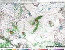
 
Certainly seeing a better signal from the euro now with a system lifting north in the fantasy range. Would say it makes its only slightly less likely that the gfs is still out to lunch.

And ironically the crazy GFS has no Gulf TC on its 6Z for the 1st run since way back at 18Z of 9/14! It just has one moving just N of Cuba (not in Gulf) at 384.

Also, the wishy-washy 0Z UKMET had none.
 
And ironically the crazy GFS has no Gulf TC on its 6Z for the 1st run since way back at 18Z of 9/14! It just has one moving just N of Cuba (not in Gulf) at 384.

Also, the wishy-washy 0Z UKMET had none.
Yeah they're sniffing out something don't know if it's going to actually be anything but there are certainly trying to sniff something out
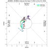
 
Yeah they're sniffing out something don't know if it's going to actually be anything but there are certainly trying to sniff something out

The MJO is heading toward favorable phases for TCG at this time of year, which Joe Bastardi has been appropriately emphasizing in his call for activity:
IMG_2562.gif
 
Pretty cool to see the monsoon trough get pulled north and almost immediately start firing some threats. Have to think the first threat gets ushered ots but if that trough stays biased north any additional systems would be a threat
 
I should probably put this in banter, but I hope we’re not spending a lot of money doing research on reclassifying TCs from 50 years ago while they were in the open Atlantic.
Projects like this are a sure sign that the 2026 Hurricane Season has been historically slow.
 
The gfs has so much sloppiness over the Caribbean and west Atlantic that I wouldn't be surprised to see a junk storm come from it. At the same time I'm a big fan of seasonal trends and the trend is for nothing to survive or get going in the tropics
 
Something may be forming near the Azores:

From 8AM TWO:

Eastern Subtropical Atlantic:
A trough of low pressure located several hundred miles southwest of
the Azores is producing showers and thunderstorms that are
showing some signs of organization. Environmental conditions appear
marginally favorable for additional development over the next couple
of days while the system moves slowly over the eastern portion of
the Subtropical Atlantic. By early next week, environmental
conditions are forecast to become less favorable for
development.
* Formation chance through 48 hours...low...20 percent.
* Formation chance through 7 days...low...30 percent.

*Edit: This is now Invest 99L.
 
Last edited:
Regarding 99L, getting close to being called a TD (it likely is already per satellite pics):

ABNT20 KNHC 181428
TWOAT

Special Tropical Weather Outlook
NWS National Hurricane Center Miami FL
Issued by the NWS Weather Prediction Center College Park MD
1030 AM EDT Fri Sep 18 2026

Special outlook to update information on the area of low pressure
located southwest of the Azores (AL99) and to remove AL98 from the
outlook.

Eastern Subtropical Atlantic (AL99):
Recent satellite imagery indicates that showers and thunderstorms
are becoming better organized in association with an area of low
pressure located several hundred miles southwest of the Azores. In
addition, it appears that a well-defined center is developing. If
these current trends continue, a tropical depression could form as
soon as later this afternoon. The system is expected to move slowly
over the next several days remaining to the southwest of the Azores.
* Formation chance through 48 hours...medium...60 percent.
* Formation chance through 7 days...medium...60 percent.

$$
Forecaster Papin/Snell/Blake/Mahoney

———————

12Z UKMET is at least the 2nd full run with it as a TD but the prior run didn’t do so until hour 36 (tomorrow at 8AM EDT) before dissipating it 48 hrs later; this run has it already doing that as of 2PM EDT today and then moving very little prior to dissipating at hour 96:

GLOBAL MODEL DATA TIME 1200UTC 18.09.2026

NEW TROPICAL CYCLONE FORECAST TO DEVELOP AFTER 6 HOURS
FORECAST POSITION AT T+ 6 : 31.9N 34.2W

LEAD CENTRAL MAXIMUM WIND
VERIFYING TIME TIME POSITION PRESSURE (MB) SPEED (KNOTS)
-------------- ---- -------- ------------- -------------
0000UTC 19.09.2026 12 32.2N 33.6W 1016 20
1200UTC 19.09.2026 24 32.7N 33.2W 1014 22
0000UTC 20.09.2026 36 33.1N 33.4W 1015 22
1200UTC 20.09.2026 48 33.8N 32.9W 1014 27
0000UTC 21.09.2026 60 35.0N 32.6W 1014 25
1200UTC 21.09.2026 72 34.5N 31.9W 1015 27
0000UTC 22.09.2026 84 33.5N 32.7W 1017 25
1200UTC 22.09.2026 96 CEASED TRACKING
 
Last edited:
99L is now a cherry:

1. Eastern Subtropical Atlantic (AL99):
Showers and thunderstorms have changed little in organization since
this morning in association with an area of low pressure located
several hundred miles southwest of the Azores. However, just a small
increase in organization is likely to result in the formation of a
tropical depression as soon as later today. The system is expected
to move slowly over the next couple of days remaining southwest of
the Azores, followed by a turn to the southwest by early next week,
when environmental conditions are forecast to become less favorable
for additional development.
* Formation chance through 48 hours...high...70 percent.
* Formation chance through 7 days...high...70 percent.
 
99L is now a cherry:

1. Eastern Subtropical Atlantic (AL99):
Showers and thunderstorms have changed little in organization since
this morning in association with an area of low pressure located
several hundred miles southwest of the Azores. However, just a small
increase in organization is likely to result in the formation of a
tropical depression as soon as later today. The system is expected
to move slowly over the next couple of days remaining southwest of
the Azores, followed by a turn to the southwest by early next week,
when environmental conditions are forecast to become less favorable
for additional development.
* Formation chance through 48 hours...high...70 percent.
* Formation chance through 7 days...high...70 percent.
Looks like it will get a name. If it was moving westbound in the Atlantic we would ve watching it closely because it looks decent(for the year we are having)
 
Looks like it will get a name. If it was moving westbound in the Atlantic we would ve watching it closely because it looks decent(for the year we are having)

Tropical Weather Outlook
NWS National Hurricane Center Miami FL
800 PM EDT Fri Sep 18 2026

For the North Atlantic...Caribbean Sea and the Gulf of America:

1. Eastern Subtropical Atlantic (AL99):
Showers and thunderstorms associated with the low pressure system
located several hundred miles southwest of the Azores have become
more concentrated during the past few hours, and a tropical
depression could form later tonight or on Saturday. The system is
expected to move slowly over the next couple of days remaining
southwest of the Azores, followed by a turn to the southwest by
early next week. Environmental conditions are forecast to become
less favorable for development beginning Sunday night or on Monday.
* Formation chance through 48 hours...high...80 percent.
* Formation chance through 7 days...high...80 percent.


Forecaster Beven
 
Tropical Weather Outlook
NWS National Hurricane Center Miami FL
800 AM EDT Sat Sep 19 2026

For the North Atlantic...Caribbean Sea and the Gulf of America:

1. Eastern Subtropical Atlantic (AL99):
Showers and thunderstorms have become more concentrated near the
center of a low pressure system located several hundred miles
southwest of the western Azores since yesterday. A short-lived
tropical depression or tropical storm is expected to form later
today or tonight while moving north-northeastward at about 5 mph,
but remaining well to the southwest of the Azores. Upper-level winds
are forecast to become less conducive for development beginning
late Sunday.
* Formation chance through 48 hours...high...90 percent.
* Formation chance through 7 days...high...90 percent.


Forecaster Berg
 
Back
Top