NoSnowATL
Member
I pulled one like that out of my freezer a few days ago.
I pulled one like that out of my freezer a few days ago.
Stil love severe weather as a storm chaser, but that is the big down side of it.This is why I hate severe season, people killed killed and property gets destroyed. Some will have to start over from scratch and lose a lot of things that have sentimental value to them
Can say the same for just about any weather event. I love hurricanes being on the beach but I don’t want it to hit my house but I want it close enough to get freaked out. We are weird people.Stil love severe weather as a storm chaser, but that is the big down side of it.


 columbiasailingclub.org


WUUS52 KRAH 121512
SVRRAH
NCC037-085-105-125-121600-
/O.NEW.KRAH.SV.W.0001.260312T1512Z-260312T1600Z/
BULLETIN - IMMEDIATE BROADCAST REQUESTED
Severe Thunderstorm Warning
National Weather Service Raleigh NC
1112 AM EDT Thu Mar 12 2026
The National Weather Service in Raleigh has issued a
* Severe Thunderstorm Warning for...
Central Moore County in central North Carolina...
Harnett County in central North Carolina...
Lee County in central North Carolina...
Southeastern Chatham County in central North Carolina...
* Until noon EDT.
* At 1112 AM EDT, a severe thunderstorm was located near Carthage,
moving northeast at 50 mph.
HAZARD...60 mph wind gusts.
SOURCE...Radar indicated.
IMPACT...Expect damage to roofs, siding, and trees.
* Locations impacted include...
Sanford, Southern Pines, Pittsboro, Lillington, Carthage,
Pinehurst, Aberdeen, Goldston, Whispering Pines and Broadway.
This includes US 1 between Mile Markers 69 and 85.
PRECAUTIONARY/PREPAREDNESS ACTIONS...
For your protection move to an interior room on the lowest floor of a
building.
&&
LAT...LON 3513 7947 3539 7961 3575 7920 3564 7898
3561 7899 3555 7880 3529 7874 3519 7919
3521 7925 3516 7933
TIME...MOT...LOC 1512Z 240DEG 44KT 3527 7942
HAIL THREAT...RADAR INDICATED
MAX HAIL SIZE...<.75 IN
WIND THREAT...RADAR INDICATED
MAX WIND GUST...60 MPH
$$


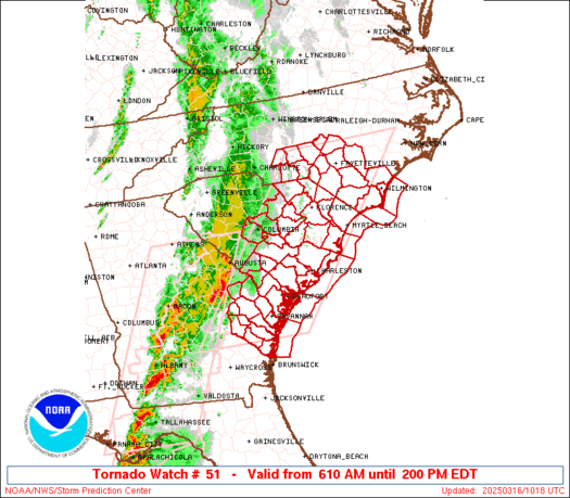
I hope folks are paying attention here.
My point and click forecast says showers likely possibility of a thunderstorm but they're not talking about storms very muchI hope folks are paying attention here.
They will closer get to eventMy point and click forecast says showers likely possibility of a thunderstorm but they're not talking about storms very much
Worried bout yall Carolina friends … nasty tornado parameters coming off latest model runsI hope folks are paying attention here.
Higher end look for this area, similarites to 2011Worried bout yall Carolina friends … nasty tornado parameters coming off latest model runs
svr checklist from the 6z euro based on krdu soundingsI hope folks are paying attention here.


With the currently modeled wind energy and dew points, I would not underestimate the overnight potential in north/central Georgia. Three tornadoes (including an EF-2) occurred between 6-7 AM yesterday morning within a marginal risk area.Wish I knew the threat lvl for GA, the spc graphs just have a gap over us between Sunday and Monday surely that’s not the case

 www.ventusky.com
NWS says nada burger outside straight line winds. cant rule out a ef0-1 spinner at worstWorried bout yall Carolina friends … nasty tornado parameters coming off latest model runs

Yeah models just keep on showing worrisome tornado parameters central and east North Carolina into southern Virginiasome of these soundings on the nam are actually insane. good thing it’s an outlier but the nam is certainly possible and shows how high the ceiling of this event is.
View attachment 194986
Large enhanced on the new Day 3
Possible high risk?


