• Hello, please take a minute to check out our awesome content, contributed by the wonderful members of our community. We hope you'll add your own thoughts and opinions by making a free account!

Misc 2022-23 Fall/Winter Whamby Thread

Status
Not open for further replies.
Might have to hold off on this for just a little bit. I keep running into snags, like this storm, which wasn't analyzed by NCSCO or NWS RAH. How could I forget the ZR I got in Raleigh when I was expecting 6-12" of snow?
View attachment 124809
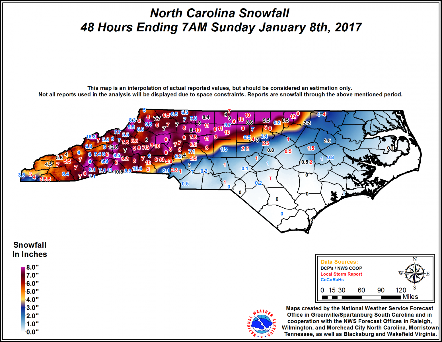
I really liked the storm. As you said, we were supposed to get a big snowstorm. But I ended up with a second-best thing in a sleetfest:
1670207970246.png
 
Might have to hold off on this for just a little bit. I keep running into snags, like this storm, which wasn't analyzed by NCSCO or NWS RAH. How could I forget the ZR I got in Raleigh when I was expecting 6-12" of snow?
View attachment 124809

Some other storms I've taken a look at tonight, either reanalyzing/giving a facelift to a pre-existing map I made, or building a new one for ice. Still got a lot of work to do.

December 12-13 2019 NC Ice Storm Map.jpg

January 23 2019 NC Ice Storm Map.jpg

December 8-9 2013 NC Ice Storm Map.jpg

February 26-27 2004 NC Ice Map.jpg
February 6-7 2003 NC Ice Storm Map.jpgJanuary 2-3 2002 NC Ice Storm Map.jpg

January 9 2015 NC Ice Storm Map.jpg
 
Last edited:
Might have to hold off on this for just a little bit. I keep running into snags, like this storm, which wasn't analyzed by NCSCO or NWS RAH. How could I forget the ZR I got in Raleigh when I was expecting 6-12" of snow?
View attachment 124809
Yeah GSP had me forecasted 5-9” of snow with this one and I ended with .25” ice topped off by .5” of snow. What’s funny is that I was worried all day leading into this storm that the surface temperatures were going to be an issue as temperatures were still near 40 as rain started around 5pm. However by 9:30 I was at 31 and looked outside to see the tree limbs starting to glaze over. Dang warm nose was way undermodeled.
 
Might have to hold off on this for just a little bit. I keep running into snags, like this storm, which wasn't analyzed by NCSCO or NWS RAH. How could I forget the ZR I got in Raleigh when I was expecting 6-12" of snow?
View attachment 124809
Who can forget the other side of this one. [See below] Easily one of my top-3 snow progg disappointments over the last 40yrs

20170107.gsp.nc.snow.accum.png
 
I'm glad I was reared in a time where posting a single frame 300 hour GFS map would get your Tom Brady Sucks banned.
Anything beyond 144 hours is for comedic purposes only. I enjoy the fanciful predictions, though. They are always wrong and remind me why we can't trust any climate model, either. So there is some value to them., but not for predicting weather.

I remember when the AFS ran out only to 72 hours. NAM was 36 hours, I think.
 
For serious reflection, I enjoy the UKMET at 144 hours and before. For casual interest and crystal ball prediction, the EURO out to 168 hours. For hoots and giggles, the GFS after 72 hours.

Severe, once in range of 36 hours, 3km NAM and HRRR long range.
 
We all know the GFS sucks. Idk why we bother with it. Wasn’t it the one who kept blowing it on hurricanes this year to?
 
We all know the GFS sucks. Idk why we bother with it. Wasn’t it the one who kept blowing it on hurricanes this year to?
Truth is they all suck beyond 7 days. Ensembles can also be misleading. Mean can be skewed by a few very cold or very snowy members. If 35 of the 51 members of the EPS are warmer than normal and 16 are way below normal skewing the mean to below average its probably going to be warmer than normal. We see it constantly with snow when a handful of members skew the mean but the majority say it's not going to snow. And usually it doesn't snow.
 
Ok so is the gfs trash or is it picking up something? It picked up the bad pacific at first in the dec 8-13 timeframe, which it looks like will be correct now that we have gotten closer. How long are we delaying this pattern change because to me I don’t see this glory pattern happening. I’m not going full panic mode right now just stating that the models continue to push things back and it seems like no end in sight.
 
Truth is they all suck beyond 7 days. Ensembles can also be misleading. Mean can be skewed by a few very cold or very snowy members. If 35 of the 51 members of the EPS are warmer than normal and 16 are way below normal skewing the mean to below average its probably going to be warmer than normal. We see it constantly with snow when a handful of members skew the mean but the majority say it's not going to snow. And usually it doesn't snow.
But 84 hour NAM, is wasaay better! ???‍♀️
 
Anybody got the pretty snow maps from the 12 z Euro run, please? For my neck of the woods?
 
Ok so is the gfs trash or is it picking up something? It picked up the bad pacific at first in the dec 8-13 timeframe, which it looks like will be correct now that we have gotten closer. How long are we delaying this pattern change because to me I don’t see this glory pattern happening. I’m not going full panic mode right now just stating that the models continue to push things back and it seems like no end in sight.

I agree with you. Evidently we are supposed to go to neutral to positive PNA but I don’t see it happening so quickly


Sent from my iPhone using Tapatalk
 
I mean.. the gfs has been consistent with warmer weather while the EURO has been consistent with a pattern change. One has to be onto something


Sent from my iPhone using Tapatalk
 
we had 2 icestorms and 4 inches of powder down this way last winter. we are like winter weather camel's down here we can store that ---- up for another 6 years!
 
“No arctic air anytime soon”. That’s so sad lol
7d588a34931a1c39495c49de63bb949b.jpg


Sent from my iPhone using Tapatalk
We live in the Southeast. Snow is hard to come by. People tend to forget that when they see snow in the west. The west coast gets more snow and should. When your area avg 1-3 a year that doesn’t mean you get 1-3in a year. It’s avg over time.
 
We live in the Southeast. Snow is hard to come by. People tend to forget that when they see snow in the west. The west coast gets more snow and should. When your area avg 1-3 a year that doesn’t mean you get 1-3in a year. It’s avg over time.
The closet weenies make it so fun though. The doom and gloom posts when we all haven’t a clue what’s gonna happen in the end. Posts of every model that shows nothing while they wish for a historic event is comical
 
We live in the Southeast. Snow is hard to come by. People tend to forget that when they see snow in the west. The west coast gets more snow and should. When your area avg 1-3 a year that doesn’t mean you get 1-3in a year. It’s avg over time.
I agree mostly. The mountains out there rack up. Seattle and places along the coast is what irritates me. Seattle averages 6 inches a year. Not much more than the GSP to CLT to RDU corridor. It's not the lack of snow that irritates me here as much as it is the constant above average temps in winter. Especially December. We should not go 12 years without a below average December and we're well on the way to doing it again.
 
I agree mostly. The mountains out there rack up. Seattle and places along the coast is what irritates me. Seattle averages 6 inches a year. Not much more than the GSP to CLT to RDU corridor. It's not the lack of snow that irritates me here as much as it is the constant above average temps in winter. Especially December. We should not go 12 years without a below average December and we're well on the way to doing it again.
It's really strange that Seattle only averages 6" considering they have had some really big snowfalls. They had nearly 70" in one winter. Have any of the big cities in NC ever had 70" in a winter ? It seems very strange for a city that averages 6" to get 70" in a winter. They have a really interesting climate.
 
Status
Not open for further replies.
Back
Top