LickWx
Member
Is it really forecasting and serious discussion if what we mostly discuss and post is the snowiest models…..
oh, if rgem had a big snowstorm and nam didn't you can bet the nam would be tossed but the rgem not.Is it really forecasting and serious discussion if what we mostly discuss and post is the snowiest models…..
I’ve found the best approach to get an idea of what’s going on is to visit multiple forums . Right now my go to are here , mid Atlantic americanwx and nyc American wx. Each paint a different picture . I do the same for long range pattern . Here and wxdisco ( old accu weather forum )oh, if rgem had a big snowstorm and nam didn't you can bet the nam would be tossed but the rgem not.
I’ve found the best approach to get an idea of what’s going on is to visit multiple forums . Right now my go to are here , mid Atlantic americanwx and nyc American wx. Each paint a different picture . I do the same for long range pattern . Here and wxdisco ( old accu weather forum )
But it’s not 33 and 34 degrees the entire time. You keep saying this but we’re dealing with a column that’s crashing and already cold antecedent conditions.I joke in jest, We know they aren't getting a foot of snow. 1. it's not going to be 10:1 ratios, and 2. only half of what falls will linger. Can't get efficient accumulation when it's 33 and 34 degrees.
Yeah , heavy wet snow . Column crashing is fun.But it’s not 33 and 34 degrees the entire time. You keep saying this but we’re dealing with a column that’s crashing and already cold antecedent conditions.
It was 38 degrees when it started snowing on both 12/18 and 1/23/03.
I never stated the entire event, but there will be a several hour window of snow (maybe more) @ or above 32 degrees. You will not get efficient accumulations.But it’s not 33 and 34 degrees the entire time. You keep saying this but we’re dealing with a column that’s crashing and already cold antecedent conditions.
It was 38 degrees when it started snowing on both 12/18 and 1/23/03. You are not dealing in reality.


You must not be on here much. Too busy doing “things” that you say you really need to do all the timeYes and I dont recall seeing much of their overnight runs, or the cmc much at all no matter which run.
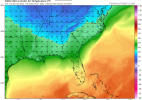
Both situations would verify as 32/SN for both locations. It’s not ideal, I’ll agree, but it’s also not going to snow for hours at 34 like the models show, either. Models often keep BL temps too high in such situations, when in reality 2m temps almost always drop to freezing.I never stated the entire event, but there will be a several hour window of snow (maybe more) @ or above 32 degrees. You will not get efficient accumulations.
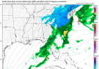
This whole column crashing is 100% rate driven, so if the rates aren't as strong as depicted on the NAM, then you can be even warmer.
View attachment 110640
View attachment 110639
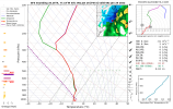
And since I was referring to Bern in my first post, here's the GFS sounding for Bern.
View attachment 110643
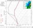
And here's Durham. GFS doesn't show below freezing till after precip is moving out.
View attachment 110645
You know me man...most of the time, I'm going to ride out with you and suit up with the cold first jersey. In this case, if we get light precip, honestly, who cares if it's rain or snow. It's going to come down in the middle of the night and probably won't amount to more than a dusting. But if we get rapid cyclogenesis off the coast, there will be plenty of precipitation and plenty of that will be snow. It won't be efficient at first, but it'll get there.I never stated the entire event, but there will be a several hour window of snow (maybe more) @ or above 32 degrees. You will not get efficient accumulations.
This whole column crashing is 100% rate driven, so if the rates aren't as strong as depicted on the NAM, then you can be even warmer.
View attachment 110640
View attachment 110639
And since I was referring to Bern in my first post, here's the GFS sounding for Bern.
View attachment 110643
And here's Durham. GFS doesn't show below freezing till after precip is moving out.
View attachment 110645
