Unreal

You may see the silhouette of my middle finger in my floodlightis there still a chance for charlotte to see something?
You may see the silhouette of my middle finger in my floodlight


Whoa statesville
Looks like that’s what’s starting to happen.They are right under the narrow heavy band, wonder if it will pivot se like some models showed
 00z RGEM showed
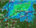
 Greensboro looks to be the real winner, already snowing with a couple hours of snow heading their way
Yup. Taking a hard SE turn now@Myfrotho704_ Is that band in Statesville legit moving S/SE?


I hope we aren't too far west for itThe most exciting thing about this, is that this band is strengthening as it pushes south View attachment 155424

@Myfrotho704_ How long do you think we have until that band potentially crosses over us?
I just saw GSPs radar and that band is really looking healthy across the board. We might get smoked lolNorth CLT/kannapolis/concord/huntersville should be the next 30-45 minutes when it enters. Nice backbuilding occuring on GSPs radar as well probably gonna see a response on TCLT soon as it gets closer to the ground
I think we should be fine I think that bit of green in lincolnton might cross right over us.Love the look of the band, may be our payoff. Hope I’m not too far sw in Matthews