It is tough to know what to root for now. Many people will have different opinions on this I am sure. It seems to me though if we are still going to pull for the baja low energy, we need it to speed up & eject quicker... Not just eject later. If it's going to eject later (like the 12z Euro), I imagine we need to go all in on the Northern stream dig.
-
Hello, please take a minute to check out our awesome content, contributed by the wonderful members of our community. We hope you'll add your own thoughts and opinions by making a free account!
You are using an out of date browser. It may not display this or other websites correctly.
You should upgrade or use an alternative browser.
You should upgrade or use an alternative browser.
Wintry 1/9-12 Winter Potential Great Dane or Yorkie
- Thread starter SD
- Start date
EmilyWx
Member
In my opinion today didn't really answer any questions and brought more uncertainty. It's worth noting that we should get better sampling of our potential UL energy within the next few days or so once it reaches land. 18z ECMWF follow suit in swinging our ULL east. We will have to monitor to see if future runs follow this solution.
Correct. Rarely in these situations where phasing is involved do we get any sort of clarity beyond 4 days out or so. The important thing to me is just not losing any of our main players. So far, we haven't.In my opinion today didn't really answer any questions and brought more uncertainty. It's worth noting that we should get better sampling of our potential UL energy within the next few days or so once it reaches land. 18z ECMWF follow suit in swinging our ULL east. We will have to monitor to see if future runs follow this solution.
You can't make the cake unless you have all the ingredients, so that's step one. Step two is putting them together.
Watching these models try to figure out whats going on at D7+ is like not knowing how to cook and trying to make a cake without a recipe. But I guess as long as we have all the ingredients, we might accidentally get it right.
Welcome aboard, btw!
NBAcentel
Member
lol this EPS run would have been way different 
packfan98
Moderator

Like the look on the end of the 18z ECMWF.. We're at 180hrs or so.. I don't think the very high end scenarios are completely off the table. A scenario is still in the cards where the Baja SW kicks out and phases and bombs out in the gulf, leading to a classic Miller A like we were seeing in models several runs ago. I'd say the 18z ECMWF took a decent step in that direction. It isn't the most likely scenario, it also isn't the only snowy scenario, but it can't be ruled out.

I know the totals are light but this is the most members the GEFS has had for snow for BHM throughout maybe the whole event since it got under 240.

iGRXY
Member
A lot of different options here that will affect people differently. If we stick to leaving the S/W in the southwest we have got to hope and pray the N/S energy drops down fast and further west, scoop of a piece of the Baja low in a partial phase and try and pop a nice coastal. If we get the 18Z GFS the 85 and I20 crew east of the apps are going to get absolutely robbed. And even those further west probably are looking at a 1-4” max. The I95 guys would also get into the mix like those out west. People will be happy but it really puts a damper on things if all we can do is get a partial 1-4” snow for part of the board in what is easily the best pattern we’ve had in 3 years.
The other option is the S/W ejects in time and we try and hold confluence to keep heights out east down and get a mauler or even get a a full phase with the northern stream dropping down to inject fresh cold air into the system. That would require a lot of timing and a lot can go wrong in that scenario also. A true boom or bust kind of thing. If you miss the phase it’s going to get shredded from the N/S or if the N/S doesn’t drop you’re going to get amplification out ahead.
Again, I’d rather just try and trend to a nice overrunning setup and get an over performing FGEN front end thump minimum and see where the warm nose ends up setting up at this point. That seems like the easiest option to get multiple portions of the board involved and while it may damper an all snow event you can get some big totals still.
wow
Member
I think we can narrow the snowfall depth range down to 0-30"Like the look on the end of the 18z ECMWF.. We're at 180hrs or so.. I don't think the very high end scenarios are completely off the table. A scenario is still in the cards where the Baja SW kicks out and phases and bombs out in the gulf, leading to a classic Miller A like we were seeing in models several runs ago. I'd say the 18z ECMWF took a decent step in that direction. It isn't the most likely scenario, it also isn't the only snowy scenario, but it can't be ruled out.
wow
Member
By the way my favorite part of the model chase is analyzing the 500mb vorticity maps down to the smallest bend in the height lines lol
I tell ya if gambling got into the model prediction world we'd all be homeless here
I tell ya if gambling got into the model prediction world we'd all be homeless here
NBAcentel
Member


 This setup is painful. Little H5 ticks and changes like this
rburrel2
Member
Just my two cents, but I think it could be better because it's dropping the first northern piece down far enough behind the first lobe that it may sort of allow some of that part to escape and get pulled in to the next northern stream wave coming down and heading our way. While the middle vort gets left behind and shunted towards the pacific.
We saw some of these scenarios a day or two ago and they lead to a decent overrunning type event, maybe?
Microsoft's model (Aurora) has a pretty decent look to it...


rburrel2
Member
Those moderate event slider type events the AI was showing before the big dawgs, started with a decent feed of moisture in Texas and did progress it East in our direction, lets hope that's where the Euro/EPS is going with this, I suppose.
This Aurora model looks like the best of all worlds, but limited maps.
I trust MS to have fed this thing more data than probably all the other AI models out there too.
I trust MS to have fed this thing more data than probably all the other AI models out there too.
rburrel2
Member
We're back! well sort of... The 18z Euro AI leaves behind our cut off, but does a much better job digging the northern stream and generates a light event for all of us. We can take baby steps and improve on this!
Last edited:
- Joined
- Nov 29, 2021
- Messages
- 42
- Reaction score
- 144
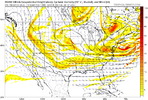
I don't post here much, but I love to follow this thread and others. I appreciate many of yall's dedication and vigor towards the evolving trends and weather. I like the end of the look on the RGEM at 84 hr with a less detached Baja low in sync with the broader flow. I'm too young to remember, but a weather mentor friend of mine a lot older than me told me a story about Matthew Holiday/Firsthand weather making a wild prediction about a subtle ULL over the four corners that ended up phasing with the main jet and brought snow to AL and other parts of the south. How the story was told to me was Matthew made the bold forecast and then was blasted by James Spann online only for Spann to be humbled because the storm evolved exactly as Matthew said it would. Based on how it was described to me, I'm wondering if this situation is similar or if anyone remembers what I'm talking about, as I was too young at the time. It may have been around 2014. I have attached a comparison between the RGEM and GFS at 84 HR for reference. Note how different the energies look. One of these models if going to have to make a big adjustment in the coming days.
Attachments
- Joined
- Nov 29, 2021
- Messages
- 42
- Reaction score
- 144
Oh, and by the way, the RGEM was the first model to pick up on Matthew's solution with that storm is what I remember.
Downeastnc
Member
We're back! well sort of... The 18z Euro AI leaves behind our cut off, but does a much better job digging the northern stream and generates a light event for all of us. We can take baby steps and improve on this!
I'm fine with this...really we don't want to see a trend to a big dog until mid next week. I guess I am old school but I would rather expect a middling event and have it trend to something better at the last moment than watch run after run smoking us with a big dog only to see it trend away the last 48 hrs. Overall the pattern is one that pays off so we just have to hope it comes through.

wow
Member
I invite everyone to read the model discussions from Gary Gray leading up to the '96 blizzard starting just 4 days prior. The MRF and AVN are what became thr GFS and the ETA became the NAM for all you youngins.
 www.americanwx.com
The Gary Gray Files - Jan '96
I had these archived and published on a site but no longer hosting it. Figured I would post them all here. These are the usenet posts from Gary Gray leading up to the Blizzard of '96. Keep history alive. Jan 3 1996: Subject: The Mid-Atlantic's Turn??... <1/3> From: [email protected] (A.K....
www.americanwx.com
NBAcentel
Member
Northern stream is a safer option, but lower ceiling unless we slow it and hook it, I say we partial phase it to the point of slowing the N/S but not full on phasing it. Thats my best option imo
I am rooting for everyone to have a good timeIt is tough to know what to root for now. Many people will have different opinions on this I am sure. It seems to me though if we are still going to pull for the baja low energy, we need it to speed up & eject quicker... Not just eject later. If it's going to eject later (like the 12z Euro), I imagine we need to go all in on the Northern stream dig.
")
I am also rooting for the low to get shoved to the Galapagos at this point
Trying to visit that site on a mobile device is hell with all the pop up ads. Will need to visit from my desktop.I invite everyone to read the model discussions from Gary Gray leading up to the '96 blizzard starting just 4 days prior. The MRF and AVN are what became thr GFS and the ETA became the NAM for all you youngins.
The Gary Gray Files - Jan '96
I had these archived and published on a site but no longer hosting it. Figured I would post them all here. These are the usenet posts from Gary Gray leading up to the Blizzard of '96. Keep history alive. Jan 3 1996: Subject: The Mid-Atlantic's Turn??... <1/3> From: [email protected] (A.K....
accu35
Member
Is there any snow back west?
The 18z AIFS reminds me a bit of the first mid-January 2022 storm (the bowling ball ULL one, not the coastal).
The waves follow similar paths and have fairly strong SE Canada lows. Although, I remember the January 2022 storm trending to more mixing because the bowling ball wave separated from the cold source too much. Fortunately, we have a bit more cold air in place with this setup.
With this potential, we have less amplification but a greater cold source. My personal rule is that if precipitation is non-zero, it will usually trend upward by the time the CAMS show up. See January 2018, and December 2017.
If we say goodbye to the Baja low interaction, I foresee the wave trending sharper as we get closer.
Last edited:

rburrel2
Member
The best news of the 18z runs is that the GEFS started nibbling on some moderate events. Thats an uptick from the basically 0 it's been showing. Would love to see that trend continue.
NBAcentel
Member


I think the 18z EC AI represents an almost best-case scenario, but one I think stands a realistic chance, also. It phases with vorticity streaming out ahead of the baja low, and explodes just offshore. Had the northern stream dug harder and phased sooner, that would have been a big dog closer to the coast.


Is there any snow back west?
1-2”
Sent from my iPhone using Tapatalk
1-2”
Sent from my iPhone using Tapatalk
Birmingham east
Sent from my iPhone using Tapatalk
All the flipping and flipping is insane. Wait till Sunday afternoon and there will start to be consensus. We will also know whether models ice or under perform. I’m just trying to be real patient and glad we got a look that could be fruitful
Sent from my iPhone using Tapatalk
Sent from my iPhone using Tapatalk
All the flipping and flipping is insane. Wait till Sunday afternoon and there will start to be consensus. We will also know whether models ice or under perform. I’m just trying to be real patient and glad we got a look that could be fruitful. As someone said earlier. Really complex forecast
Sent from my iPhone using Tapatalk
Sent from my iPhone using Tapatalk
Stormlover
Member
You quoted yourself?Sent from my iPhone using Tapatalk
NBAcentel
Member
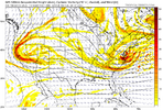
Here was the graph cast total QPF from the storm and 2mt with corresponding frames


>


>


Total QPF
>
>
Total QPF
NBAcentel
Member
Imagine we do manage to bomb out the northern stream over us/just past us and set up confluence/a cold feed for the actual ejecting Baja low later on…. HeheI think the 18z EC AI represents an almost best-case scenario, but one I think stands a realistic chance, also. It phases with vorticity streaming out ahead of the baja low, and explodes just offshore. Had the northern stream dug harder and phased sooner, that would have been a big dog closer to the coast.
View attachment 159214
View attachment 159213
god if we reel this storm in it will be like catching a 15 pound bass out of a farm pound a day after 10 inches of rain. This some hard work up in here
Here's the latest Graphcast (from 12z). It's pretty much like what I mentioned earlier - a sharper wave version of the 18z GFS - and it yields a bit more snow this run compared to its last run. The wave digging into the C Plains taps the baja wave, then moves east.


rburrel2
Member
After carefully scrutinizing the end of the 12z Ukmet and comparing it to some other previous various global/AI runs... I feel pretty confident in saying it was going to be an epic winter storm for most of us.