ForsythSnow
Moderator
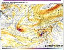
12Z NAM was a good hit for many in AL and GA, let's bring an event for us home

I haven’t looked at the models but what’s with the sharp cut off going into Sc. Is it no precip or just not cold enough for snow?12Z NAM was a good hit for many in AL and GA, let's bring an event for us home
Marginal tempsI haven’t looked at the models but what’s with the sharp cut off going into Sc. Is it no precip or just not cold enough for snow?
On the other hand the NAM isn’t far from skunking AL, GA and hitting TN.NAM is very close to a much bigger deal. A couple degrees from a blistering.
Given the track and upper air, this system really has a chance. In the end, though, it has heartbreak written all over it. As modeled, above freezing surface temps with rate dependant snowfall happening during the middle of the day will any real make accumulations extremely difficult.Hope the NAM is onto something but there is absolutely not a single ensemble member from the EPS or GEFS with any snowfall, I don’t like that.
Such a beautiful track though
Not sure how far it is from what happened in Feb 2020 but I have a similar feel to it. Small event that showed up and was really mostly ignored to be maybe a dusting event at best until the modeling got closer and it turned into a nice event for many across N GA.Wow I hadn’t been following this. Let’s reel it in
Tuesday looks very interesting. Lots of energy at H5.12z is out
I think this is the event you were referring to.Not sure how far it is from what happened in Feb 2020 but I have a similar feel to it. Small event that showed up and was really mostly ignored to be maybe a dusting event at best until the modeling got closer and it turned into a nice event for many across N GA.
Thread stays as there's still discussion regarding the system as well as a potential. It's also 3 days away so if it's showing up on modeling then it's valid enough for its own thread. With all the flipping globals have been on recently they're not too smart on tracks and moisture output so I would pay more attention to H5. Our wave is sitting over the SW rn as that Baja low. Its interaction with the jet will be what makes or breaks it. The NAM keeps it a lot stronger while the GFS weakens it too much but its still there.I think we should wait until the NAM gets into better range to start the thread tbh
Gotta be amped to have a shot.GFS was similar to RGEM. Suppressed and warm

Yeh, FFC has my high at 47 Tuesday. That’s a pretty big gulf to close with the NAM.There’s nearly a 15 degree surface temp difference between the GFS and the NAM at 7 PM Tuesday. I know it’s the long-range NAM but still… what gives?
Wow when did this happen? looks like central and north Alabama won't be getting out of the lower to mid 30s Tuesday. Very intrigued. Is this system even sampled yet?12Z NAM was a good hit for many in AL and GA, let's bring an event for us home
It comes down to interactions with the jet. It's over Baja right now as the cutoff and is supposed to merge Monday or so before making its way east.Wow when did this happen? looks like central and north Alabama won't be getting out of the lower to mid 30s Tuesday. Very intrigued. Is this system even sampled yet?
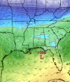
Definitely looks like snow levels will be around >2500' right now, but still a few days away.At 69 hours this is all rain for Atlanta. I think this is only going to be rain here. Mountains may still have a chance at frozen.
I’m at Beech….the only way I’ll ever score being from farther east than you even?Ofc, I'm on the wrong side of the cutoff like I am nearly every storm.
Storm is there. But warm 925 to surface. Some upper level support though pushing 850s below freezing in same locations as 12z.

Was just about to post about this .. seems very light on a lot of models and would be the definition of a flizzardThe 00z 3k NAM has some light snow across NC.
View attachment 110274