• Hello, please take a minute to check out our awesome content, contributed by the wonderful members of our community. We hope you'll add your own thoughts and opinions by making a free account!

Pattern August is the worst month of the year and it's not even close thread

Severe Weather Statement
National Weather Service New Orleans LA
314 PM CDT Fri Aug 21 2026

LAC033-037-091-212100-
/O.CON.KLIX.SV.W.0124.000000T0000Z-260821T2100Z/
St. Helena LA-East Feliciana LA-East Baton Rouge LA-
314 PM CDT Fri Aug 21 2026

...A SEVERE THUNDERSTORM WARNING REMAINS IN EFFECT UNTIL 400 PM CDT
FOR ST. HELENA...EAST CENTRAL EAST FELICIANA AND NORTHEASTERN EAST
BATON ROUGE PARISHES...

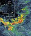
At 313 PM CDT, a severe thunderstorm was located near Gillsburg, or
12 miles north of Greensburg, moving south at 15 mph.

HAZARD...Tennis ball size hail and 70 mph wind gusts.

SOURCE...Radar indicated.

IMPACT...People and animals outdoors will be injured. Expect hail
damage to roofs, siding, windows, and vehicles. Expect
considerable tree damage. Wind damage is also likely to
mobile homes, roofs, and outbuildings.

Locations impacted include...
Greensburg, Montpelier, Darlington, and Easleyville.

PRECAUTIONARY/PREPAREDNESS ACTIONS...

Prepare immediately for large hail and deadly cloud to ground
lightning. Seek shelter inside a well-built structure. Stay away from
windows.

Continuous cloud to ground lightning is occurring with this storm.
Move indoors immediately. Lightning is one of nature`s leading
killers. Remember, if you can hear thunder, you are close enough to
be struck by lightning.

&&
Wait... tennis ball sized hail?? That's going to be a bad day for vehicle windshields. Prayers for those in the path of this thunderstorm.
 
Severe Weather Statement
National Weather Service Raleigh NC
648 PM EDT Fri Aug 21 2026

NCC037-063-135-183-212315-
/O.CON.KRAH.SV.W.0233.000000T0000Z-260821T2315Z/
Orange NC-Wake NC-Chatham NC-Durham NC-
648 PM EDT Fri Aug 21 2026

...A SEVERE THUNDERSTORM WARNING REMAINS IN EFFECT UNTIL 715 PM EDT
FOR SOUTHERN ORANGE...WEST CENTRAL WAKE...EASTERN CHATHAM AND DURHAM
COUNTIES...

At 647 PM EDT, a severe thunderstorm was located 8 miles southeast of
Carrboro, or 9 miles south of Chapel Hill, moving east at 40 mph.

HAZARD...60 mph wind gusts.

SOURCE...Radar indicated.

IMPACT...Expect damage to roofs, siding, and trees.

Locations impacted include...
Raleigh, Durham, Cary, Chapel Hill, Hillsborough, Pittsboro, Garner,
Carrboro, Goldston, and RDU International.
 
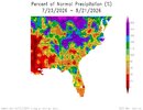
Only had a pitiful 0.3" today despite pretty bad flooding about 15 miles away in NC. Oh well.

Worked from home today and was treated to going on 7 hours now of constant rolling thunder and incalculable lightning strikes since the storms were so close and back building. Haven't seen that kind of electrical storm in a very long time in this area. For the first time you could feel the beginning of the end for summer today. What rain we had was cold and it got down to 70 during the showers.
 
Currently 71/70 with light rain and thunder. I'd have to double check but that might be the lowest temp/DP we've had since the last couple days of June going by the PWS graph.
 
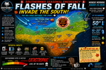
Greg Fishel posted this on Facebook. I guess we're getting practice for winter.

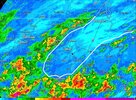
Many areas got the expected heavy rainfall, but not everybody. In fact, if you're inside of the white line I drew on top of the radar estimated rainfall amount image, you got less than an inch, and in some areas north and east of Raleigh, well less than inch. Once the sun went down, the area of heavy rain coming in from the west just collapsed. So once again, we have winners and we have losers.

1000062938.jpg
 
The .36 inches in my rain gauge at my house near Lake Wheeler in Wake County was welcome but it was a disappointment looking at some of the rain totals in surrounding areas. The NWS in Raleigh was crying wolf again about a multi inch rain event for Wake County as they have many times this summer. Whenever they write local forecasts, they should leave Wake County out of any flood warnings and put precipitation chances at a bare minimum for any state wide precipitation event.
 
The .36 inches in my rain gauge at my house near Lake Wheeler in Wake County was welcome but it was a disappointment looking at some of the rain totals in surrounding areas. The NWS in Raleigh was crying wolf again about a multi inch rain event for Wake County as they have many times this summer. Whenever they write local forecasts, they should leave Wake County out of any flood warnings and put precipitation chances at a bare minimum for any state wide precipitation event.
0.36" in Summerfield, as well. Very disappointed that we didn't get more, but I guess it's baby steps.
 
I picked up 1.05" from the storms yesterday. Was not worth it - with those storms came 60mph winds and of course (of course the day after landscaping cleaned everything up from the last storm) created a big big mess. I have schit down everywhere and my property is a complete mess.

Not worth it - take it back
 
Round II commencing this morning around Topsail Island this morning.. Lotsa Rain & Thunder/Lighting
 
It feels amazing outside right now!!


Sent from my iPhone using Tapatalk
It does feel much better outside. It's a good day for a walk in the woods and that's what I am about to do. I'm going to look at a piece of property east of Rocky Mount that I might be interested in. It is mostly woods with a creek running through it. It would serve as the perfect escape hatch from Wake County which is growing a little too fast for this old country boy. Even if I decide to buy it and never build on it, the timber would have some value and I could always use it for recreational purposes like hunting, fishing the creek with a ultralight and even four wheeling.
 
Yeah big time. Days getting shorter by about 2 minutes a day for most of us. Sun angle much less intense as well. Sun angle was 78 degrees on July 4th, 73 on August 1st, now down to 67 today (for my area).. Met Fall is almost here man!
Noticeably getting dark earlier. It's awesome.
 
Back
Top