GeorgiaGirl
Member
I don't think there's been a day without rain since I got back from Charleston/Edisto. Granted, the most recent days have been light, and I'm not sure how much we'll get here with this storm that pushed over.

Looking forward to low TDs for June 3-4!Just saw this on the GFS, would be a big help but damn thats chilly for early June
View attachment 196210
Enjoy it, because it could be the last time with comfortable Dew Points until September !Looking forward to low TDs for June 3-4!
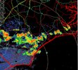
Rinse and repeat. Same cape levels! @Shaggy @Downeastnc @NCSNOW how you guys doing with the 70+ degree DPs and 90+ degree temps?! Fropa just passed here and its 85/59.


View attachment 196193
Just think, we get through today, and saturday, and then we have a nice week!
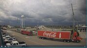
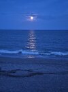
Doesnt beat this after the fropa we had earlier.A new first for me with this recent wet pattern...a rainbow before a heavy shower moved in. Have seen countless rainbows after a shower/storm but Tuesday evening marks the first one beforehand. Added bonus, it was paired with a vibrant sunset.
View attachment 196204
View attachment 196206
View attachment 196207

I just hope this rainy pattern keeps up all summer, with cooling rains, between the steam heat and stillness. Much better than Bermuda high blast furnace smoggy dry with the temps getting turned up day after day. Tstorm hail, mostly cloudy, storm winds, so much better than 103 and nothing.Looking forward to low TDs for June 3-4!

Check out the 40s DPs in RDU/GSO!Enjoy it, because it could be the last time with comfortable Dew Points until September !

I don't think there's been a day without rain since I got back from Charleston/Edisto. Granted, the most recent days have been light, and I'm not sure how much we'll get here with this storm that pushed over.

This is why you don’t want dry air masses in the summer months. They inevitably always heat up and turn into the death ridge and become impossible to move.The June thread isn't up yet but it looks like we are going into the oven after next weekend with several 100 degree days possible according to the GFS. We had better enjoy the cooler temperatures this upcoming week.
This sounds a lot like the way 2002 went to me.Most of the "chatter" in the energy and agriculture communities in the past week has sprung from a somewhat vague/hidden source that suggested that the so-called "Super El Nino" was going to make for a cold summer across the entire lower 48 states in the JJA semester. The problem is, of course, that the current ENSO state is a weak signature, evolving and taking a different course than what was seen in the summer of 2015, the only true "Super El Nino" on record. The sea surface temperatures then featured a very warm Indian Ocean, eastern Pacific Basin and Gulf of Alaska, and a huge Atlantic Ocean positive hydrothermal anomaly. In effect, there was a vast area of water that was much warmer than normal in addition to the equatorial realm, which was a full basin case (between the Marianas Trench and the Galapagos Islands.
That difference is important because it tells you that the apparent weather which occurred 11 years ago is unlikely to happen this time around. Also, the ENSO structure is still evolving, and likely will not reach a peak until perhaps November. The MDR of the equatorial Atlantic Ocean is actually a little colder than what it was a couple of months ago, as is the Gulf of Alaska. If you have not noticed, most of the model forecasts, like those of the summer of 2015, are fairly warm. You see, a true "super size" oceanic warm event supports a mostly hot summer in the lower 48 states, Europe, the Middle East and Central Asia. There will be advances of cold upper lows form the Aleutian Islands these next two weeks, but that is typical of June and would allow some ferocious heat build-ups in Mexico, Texas and the Great Plains. Thunderstorm risks will be higher but further north close to the Canadian border. Tropical cyclone risks will be less, with more "homegrown" disturbance off of Cape Hatteras, in the Gulf of Mexico, and later in the Caribbean Sea. 13 named storms, 6 hurricanes, and 2 major category cyclones remains my call, with the greatest strike potential being from Florida and up along the Eastern Seaboard.
Just so you are wondering, I think the third week of September, like a traditional El Nino, will see a pattern breakdown that resurrects the southern branch storm track and sets up excessive rainfall, thunderstorms and cooler temperatures in an arc from California to Texas to Florida/Georgia. But before we get there, plenty of hot weather dented by the occasional cold front and convection in the north central, Great Lakes, and Northeast.
Prepared by Meteorologist LARRY COSGROVE on
Saturday, May 30, 2026 at 11:45 P.M. CT
.png")
Nope July.Well at least in June we start losing daylight?
View attachment 196221

Nope July.