-
Hello, please take a minute to check out our awesome content, contributed by the wonderful members of our community. We hope you'll add your own thoughts and opinions by making a free account!
You are using an out of date browser. It may not display this or other websites correctly.
You should upgrade or use an alternative browser.
You should upgrade or use an alternative browser.
Pattern June’s Drought Dialogues
- Thread starter SD
- Start date
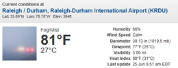
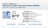
I think RDU's low will be 80 for last night. Currently Fog/Mist at 81 degrees.....:
View attachment 173215
If 80 were to be the 24 hour low for today at RDU and GSO, it would tie the all-time high record low for any date for both locations. It would also obliterate the previous high June low for GSO of 77.
However, any thunderstorms today or this evening should easily get it below 80, even if they’re only in the general vicinity and not right at these locations. Also, per RDU:
THE ALL-TIME RDU RECORD WARMEST OVERNIGHT LOW IS 80 DEGREES, AND THERE IS SOME MODEL GUIDANCE THAT IS SUGGESTING TEMPERATURES MAY REMAIN ABOVE THE MARK OVERNIGHT. HOWEVER, EVEN IF
TEMPERATURES DO REMAIN THAT WARM OVERNIGHT, THE CURRENT FORECAST
DOES PREDICT THAT TEMPERATURES WEDNESDAY EVENING WOULD LIKELY FALL
BELOW 80 BEFORE MIDNIGHT. EXPECT WIDESPREAD LOWS ONCE AGAIN IN THE
70S.
Last edited:
I'd like a storm today but at this point I'll take an outflow boundary. High convective coverage today seems like it wiggle help zap the heatwave with the upper ridge waning but the mid level temps staying stagnant over turning seems like the best way to back the heat down through Sunday
snowc
Member
snowc
Member
SEVERE THUNDERSTORM WATCH #459 HAS BEEN ISSUED UNTIL MIDNIGHT.


Last edited:
snowc
Member
If the above image doesn't show (they should be by now due to SPC issuing MDs over NC), refresh page.
UPDATE: The WWs have been issued.
UPDATE: The WWs have been issued.
Last edited:
snowc
Member
Remember the old saying Sharif struck by lightning?Eighteen?! Wow.
That's what it felt like.
With apologies to The Clash...
snowc
Member
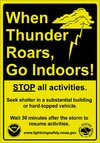
And that's why the NWS puts this dire warning on the SVRs and SVSs.Standard precaution for lightning strikes near bodies of water be it the ocean, a lake, a pool, a puddle or whatever is GTFO of the water. 18 people FA'd and FO.. smdh
If on or near <insert body of lake name here> lake, get away from the water and move indoors or
inside a vehicle. Remember, lightning can strike out to 15 miles
from the parent thunderstorm. If you can hear thunder, you are close
enough to be struck by lightning. Move to safe shelter now! Do not
be caught on the water in a thunderstorm.
snowc
Member
snowc
Member
And also, NWS provides this strong notice when a storm is expected to wreak havoc across a warned area.
Large hail and/or damaging wind and/or continuous cloud to ground lightning
are occurring with this/these storm/s. Move indoors immediately. Lightning is
one of nature's leading killers. Remember, if you can hear thunder,
you are close enough to be struck by lightning.
walked and shot +2 over 12 in my golf league last night. by the time we checked score cards i could barely focus because sweat was still dribbling down my nose and my brain was completely fried. heat was no joke
Downeastnc
Member
snowc
Member
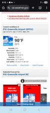
Huh? 86degree dew point. It's air you can wear!This is pretty stupid for 9 am
View attachment 173219
snowc
Member
My station said 82 last night for DP. Shattered the old record of 81.6 set on August 1 2024!
snowc
Member
Looks like today's RWT is going on as scheduled, despite threat for Severe weather.
Downeastnc
Member
Feels like summer outside
GeorgiaGirl
Member
Yeah, it feels worse out there today than it did yesterday, and I'm in the advisory/not sure I'm where the heat dome is positioned.
I'll be interested in seeing if this produces nasty storms later.
Stormsfury
Member
Humidity/Dewpoints are sky high across the board this morning. Already 90 at RDU at 9am. Unbelievably, SBCAPES already per SPC mesoanalysis running anywhere from 4000 to 5500 J/KG with some 7000 J/KG in Eastern NC.
Lead met at FFC
Stormsfury
Member
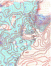
Hahaha, I just posted an analysis at the same time you uploaded what I was discussing!Some huge cape already View attachment 173221
92/83 is crazy for 945am
Last edited:
Downeastnc
Member
Should mix out some it will actually be less hot feeling at 2pm than it is now probably.
CHS breaking records for mid level lapse rates the last 12h
Downeastnc
Member
CHS breaking records for mid level lapse rates the last 12h
Every once on awhile we get a day like this and it turns real ugly....July 1 2012 for instance.
84.6/75.4 at almost 10am.
Stormsfury
Member
KCAE discussion from 634am actually stated they discussed with SPC on a potential enhanced upgrade but SPC wanted to evaluate the mesoscale environment this morning before any such possible upgrades.Every once on awhile we get a day like this and it turns real ugly....July 1 2012 for instance.
DCAPES 1500 to 1750 J/KG is insane.
Finding some soundings where DCAPE is getting very close to the sbCAPE values (in the 1700 ballpark!). should get a few beasts todayKCAE discussion from 634am actually stated they discussed with SPC on a potential enhanced upgrade but SPC wanted to evaluate the mesoscale environment this morning before any such possible upgrades.
DCAPES 1500 to 1750 J/KG is insane.
Bannerdude2
Member
93/78 HI 110 at 10:45 AM
Hotter than a $2 pistol
Hotter than a $2 pistol
NC State Climate station out on a farm near Goldsboro sitting at 91/84 (HI 117). That 84's probably a bit too high, but not completely unreasonable. KGSB was at 93/79 an hour ago, and JoCo Airport is at 91/81
snowc
Member
Or June 17 2022. 100k people without lights.Every once on awhile we get a day like this and it turns real ugly....July 1 2012 for instance.
snowc
Member
June 17 2022 repeat anyone???KCAE discussion from 634am actually stated they discussed with SPC on a potential enhanced upgrade but SPC wanted to evaluate the mesoscale environment this morning before any such possible upgrades.
DCAPES 1500 to 1750 J/KG is insane.
snowc
Member
Stormsfury
Member
If I'm not mistaken, there were locales that had 10,000 J/Kg of CAPE that day... 11,000 in KCAE IF I remember correctlyEvery once on awhile we get a day like this and it turns real ugly....July 1 2012 for instance.
snowc
Member
Downeastnc
Member
If I'm not mistaken, there were locales that had 10,000 J/Kg of CAPE that day... 11,000 in KCAE IF I remember correctly
Yeah it was some of the highest if not the highest cape I have ever seen for the region...
The NC State climate station located at Lake Wheeler about a mile from my house had a temperature of 93 degrees with a dew point of 81 producing a heat index of 113. My wife went on a morning walk around 6:00 AM this morning and came in looking she had taken a shower with her clothes on. Me and the dog were smart enough to stay at the house.

