
How is this place able to make snow ? Has to be inside some refrigerated enclosure and brung out an dumped. Scaly Mtn on GA/NC line area
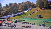




A lot of people don't realize that the Scaly Mountain Community is 500 feet higher in elevation than Boone. It doesn't explain making snow in the 60s tho.How is this place able to make snow ? Has to be inside some refrigerated enclosure and brung out an dumped. Scaly Mtn on GA/NC line area
View attachment 199192
Plastic snowHow is this place able to make snow ? Has to be inside some refrigerated enclosure and brung out an dumped. Scaly Mtn on GA/NC line area
View attachment 199192


Looks like a big chiller or some sort of HVAC doing the work.How is this place able to make snow ? Has to be inside some refrigerated enclosure and brung out an dumped. Scaly Mtn on GA/NC line area
View attachment 199192

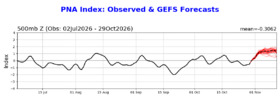
I’m rolling with Marcus. Bump the haters. December to remember.

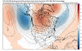
Yep!Does Marcus always post outlook maps with colored pencils? Old skool.

I’m rolling with Marcus. Bump the haters. December to remember.
