• Hello, please take a minute to check out our awesome content, contributed by the wonderful members of our community. We hope you'll add your own thoughts and opinions by making a free account!

Wintry Winter 26-27

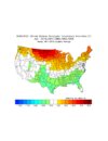
Then comes a much cooler Jan than Dec overall in the SE
2016: cool
2007: mild
1988: cold
1983: cool
1958: cold

Composite for Jan: cool SE

IMG_2906.png
——————

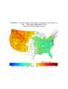
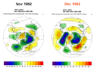
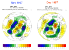
For the SE and E, the best is saved for Feb:
2016: normal
2007: cool
1988: cool
1983: cool
1958: very cold

Composite for Feb: cool to cold SE and even most of E

IMG_2907.png
 
I agree, I think that’s a favorable pattern for our more CAD Miller B setups rather than the gulf scrapers. My concern here is with the -PDO increasing heights over the northeast as it destructively interferes with our canonical ENSO pattern.
Agree. Our last significant Nino, we had a miller B winter storm. (Jonas) to be exact. Given the tendency for ridging in the north for descent and resulting high pressure and an active wavetrain associated with Nino that’s kind of the name of the game for +ENSO winters. More then often though it’s a cold rain
 
-- on the super idea
2409fa6426d6bc41dbf1a70f48c63cef.jpg


Sent from my iPhone using Tapatalk
 
Went back and Checked GSO October 72,82,97 & 15: All four of them avg BN temp wise ( 1972 by over 5 degrees BN ) and all four had over 3.0 qpf.

Fast forward to Oct 2026. Currently we are +2 AN temp wise. Who knows what that will look like after the next 3 days. Sitting at 1.26 qpf and really no prospects of any more on 360 hr guidance showing up.

So what this means/ who knows. Just find it interesting in the Preceeding OCT for other strong el ninos , This October is acting differntly so far.
 
Went back and Checked GSO October 72,82,97 & 15: All four of them avg BN temp wise ( 1972 by over 5 degrees BN ) and all four had over 3.0 qpf.

Fast forward to Oct 2026. Currently we are +2 AN temp wise. Who knows what that will look like after the next 3 days. Sitting at 1.26 qpf and really no prospects of any more on 360 hr guidance showing up.

So what this means/ who knows. Just find it interesting in the Preceeding OCT for other strong el ninos , This October is acting differntly so far.
23-24 was the only stronger nino I could find that will be even remotely close to this year as far as temps. One thing for this year though is the highly variable pacific wave train dominated pattern isnt that dissimilar from a typical strong/super but we have been biased toward the warmer side with the persistent elongated pac jet and GOA low. You can almost find 1:1 matches of our current look and some of the upcoming pattern to previous supers. I really dont see a lot of evidence that we are going to magically flip the switch and go cold, we had some building blocks on the models but the 0z runs basically destroyed that idea and we are back to more of the same with the late month pattern looking very much like late October 23. Probably going to take a swing at a fairly strong apps or west low pressure system right before or on Halloween then maybe see more of a nor easter shortly after that. I would watch the pacific construct later in the month as well. Eventually it's going to try to pump significant AN height in NW Canada and Alaska and that may be the time we start to really see the more classic nino type pattern really begin with the STJ getting into full swing, thats more of a november thread topic
 
23-24 was the only stronger nino I could find that will be even remotely close to this year as far as temps. One thing for this year though is the highly variable pacific wave train dominated pattern isnt that dissimilar from a typical strong/super but we have been biased toward the warmer side with the persistent elongated pac jet and GOA low. You can almost find 1:1 matches of our current look and some of the upcoming pattern to previous supers. I really dont see a lot of evidence that we are going to magically flip the switch and go cold, we had some building blocks on the models but the 0z runs basically destroyed that idea and we are back to more of the same with the late month pattern looking very much like late October 23. Probably going to take a swing at a fairly strong apps or west low pressure system right before or on Halloween then maybe see more of a nor easter shortly after that. I would watch the pacific construct later in the month as well. Eventually it's going to try to pump significant AN height in NW Canada and Alaska and that may be the time we start to really see the more classic nino type pattern really begin with the STJ getting into full swing, thats more of a november thread topic
Man, I blocked out winter 2023-24 from my memory, and I hope most everyone on here did the same, except those of you in TN/MS/AL.
 
23-24 was the only stronger nino I could find that will be even remotely close to this year as far as temps. One thing for this year though is the highly variable pacific wave train dominated pattern isnt that dissimilar from a typical strong/super but we have been biased toward the warmer side with the persistent elongated pac jet and GOA low. You can almost find 1:1 matches of our current look and some of the upcoming pattern to previous supers. I really dont see a lot of evidence that we are going to magically flip the switch and go cold, we had some building blocks on the models but the 0z runs basically destroyed that idea and we are back to more of the same with the late month pattern looking very much like late October 23. Probably going to take a swing at a fairly strong apps or west low pressure system right before or on Halloween then maybe see more of a nor easter shortly after that. I would watch the pacific construct later in the month as well. Eventually it's going to try to pump significant AN height in NW Canada and Alaska and that may be the time we start to really see the more classic nino type pattern really begin with the STJ getting into full swing, thats more of a november thread topic

Yea let’s not talk about 23-24.


Sent from my iPhone using Tapatalk
 
Man, I blocked out winter 2023-24 from my memory, and I hope most everyone on here did the same, except those of you in TN/MS/AL.
23/24 was full steam ahead toward Fab Feb and Mega march, models had a nice MJO progression and resultant -NAO/AO couplet, then the MJO didn't work out and into the toilet it went. Had that connected we probably look at it much more favorably than we do in our part of the world. The one cool thing about stronger ninos is they can take on a nina like flavor with more action in the pac jet and wave train where they can get some retractions with EPO/WC ridging and deliver some serious cold. We aren't even in a place to discuss that much right now but something to watch out for as we get deeper into the cold season.
 
23/24 was full steam ahead toward Fab Feb and Mega march, models had a nice MJO progression and resultant -NAO/AO couplet, then the MJO didn't work out and into the toilet it went. Had that connected we probably look at it much more favorably than we do in our part of the world. The one cool thing about stronger ninos is they can take on a nina like flavor with more action in the pac jet and wave train where they can get some retractions with EPO/WC ridging and deliver some serious cold. We aren't even in a place to discuss that much right now but something to watch out for as we get deeper into the cold season.
Understood. It often only takes only 1 event to determine if a winter is a good one or not. The joys of winter weather in the south.
 
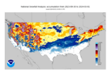
First snow of the season in progress out west. I was in Deer for 5 days and just left yesterday before it got cold enough...and now that I'm gone of course it snows lol. 3 inches there right now and still coming down. Had a lot of fun at any rate, plenty of hiking and 4x4 trails, gorgeous area any time of year really.

https://www.deervalley.com/explore-the-mountain/webcams
 
Yea let’s not talk about 23-24.


Sent from my iPhone using Tapatalk
23-24 behaved the way it did because the tropical convection in the Indian Ocean destructively interfered with the Aleutian low. Typically, during an El Niño, you get suppression in the Indian Ocean and convection in the Central Pacific, and that failed to develop. There was a paper published that ran some experiments that lowered the background ocean temperatures, and the atmosphere behaved more like a typical El Niño.

There are cases where the Indian Ocean convection can actually flip the forced response. That happened in 2005-2006, when, despite being in a La Niña, the atmosphere behaved more like El Niño in December because of what was going on in the Indian Ocean.

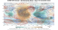
Take a look at the Nov to Feb VP 200 Anomaly from 2024. Notice how that suppressed convection over the Indian Ocean is much more dominant and eastward than the enhanced convection in the Pacific.
This plot is not dissimilar to the PNA


Then look at the EPS VP 200 forecast. Notice the enhanced convection is a bit more dominant this year and further west? This gives me more confidence we won't see a repeat of 2023-2024. However, it is a bit too early to be sure.

rossby200_d06-10.png
 
Keep in mind that in December, ENSO has less of an influence on North America weather. A strong ridge over the east coast is not a strong El Niño forced response (your second plot is).

For that reason, I wouldn’t say with confidence December is going to be a blowtorch. Off the top of my head, I can’t think of what other forces led to the warm December those years, but if anyone wants to dig into this, that might provide us some better insight on this year.

Maybe QBO?? I don’t really understand stratospheric dynamics that well.
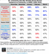
We'll see how it goes. This chart from EWebb for data from 1895-2016 doesn't show a strong bias towards warm or cool temperatures in Dec in NC when looking across all of ENSO except for warmth in Strong-Super Nino

ENSO Temp Probabilities EWebb.GIF
 
We'll see how it goes. This chart from EWebb for data from 1895-2016 doesn't show a strong bias towards warm or cool temperatures in Dec in NC when looking across all of ENSO except for warmth in Strong-Super Nino

View attachment 198876
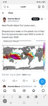
This was back in August. Dont know if this will help this winter to maybe be colder outcomes than one thinksScreenshot_20260819_213941_Samsung Browser.jpg
 
We'll see how it goes. This chart from EWebb for data from 1895-2016 doesn't show a strong bias towards warm or cool temperatures in Dec in NC when looking across all of ENSO except for warmth in Strong-Super Nino

View attachment 198876
And that's likely just because the sample size for strong El Nino's is so small.
 
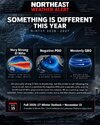
This is like Griteater level of understanding, but I think this means nobody has a clue about the upcoming winter!!IMG_6767.jpeg
 
This was back in August. Dont know if this will help this winter to maybe be colder outcomes than one thinksView attachment 198883
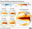
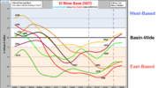
I don't think there is any way of getting around this being just a massive El Nino that is strongly east-based. Think we gotta just hope we end up with the actual weather being something closer to 82-83 than 97-98

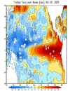
Sea Level Height Anomaly here showing higher than normal sea levels in the E Pacific and lower than normal sea levels in the W Pacific due to weakened trade winds and westerly winds pushing warm water east and piling it up in the E Pacific

Oct 11 SLH.gif


31 Nino 2+.png
 
Last edited:


Thanks for posting that. I believe this is at least partially because the high further W scenario is often associated with the deeper cold air of a solid +PNA, which is the index that correlates the most to snow in the SE US, especially snow associated with Gulf Miller A storms. The CAD scenario naturally has shallower air (850s often >0C with a mean of +2.3C) as Dr. Wall shows. So, instead of snow, sleet/ZR often are the more dominant ptypes due to the coldest air being closer to the near surface portion of the wedge. Thus the avg liquid equivalent of the total winter precip may actually be higher in the wedge situation despite less snowfall.
 
Last edited:
The Year Without Winter. Important the IOD was in Posotive suposedly back then. Currently it is in Neutral territory and forecasted to evolve into posotive phase by spring.

AI Overview


The "Year Without a Winter" refers primarily to the 1877–1878 winter in North America, an extraordinarily mild season marked by the 1877–1878 El Niño event. [1]

Key Details of 1877–1878
  • Impact in the Upper Midwest: Documented heavily across Minnesota, Iowa, and the Dakotas (via historical reports archived by the Minnesota Department of Natural Resources), the winter featured temperatures roughly 10°F to 12°F above average. [1, 2, 3]
  • Unseasonal Conditions: Farmers plowed fields into December, spring-like flowers bloomed around Christmas, lakes and rivers stayed largely free of ice, and there was a severe lack of snow for sleighing or logging. [1, 2]
  • Global Consequences: Compounded by a strong Indian Ocean Dipole and regional climate shifts, the same period triggered catastrophic droughts and famines across India (Great Famine of 1876–1878), China, and Brazil (Grande Seca), resulting in tens of millions of deaths. [1]
 
FFC put out a El Nino primer yesterday. The takeaway is that they believe the chances of wintry precipitation are elevated due to the subtropical jet providing additional chances for GOM low-pressure systems. In short, an additional number of storms increases the chance of winter precipitation if and when cold air is available.

Pretty in-depth for a public release and worth the time IMO.
 
The Year Without Winter. Important the IOD was in Posotive suposedly back then. Currently it is in Neutral territory and forecasted to evolve into posotive phase by spring.

AI Overview


The "Year Without a Winter" refers primarily to the 1877–1878 winter in North America, an extraordinarily mild season marked by the 1877–1878 El Niño event. [1]

Key Details of 1877–1878
  • Impact in the Upper Midwest: Documented heavily across Minnesota, Iowa, and the Dakotas (via historical reports archived by the Minnesota Department of Natural Resources), the winter featured temperatures roughly 10°F to 12°F above average. [1, 2, 3]
  • Unseasonal Conditions: Farmers plowed fields into December, spring-like flowers bloomed around Christmas, lakes and rivers stayed largely free of ice, and there was a severe lack of snow for sleighing or logging. [1, 2]
  • Global Consequences: Compounded by a strong Indian Ocean Dipole and regional climate shifts, the same period triggered catastrophic droughts and famines across India (Great Famine of 1876–1878), China, and Brazil (Grande Seca), resulting in tens of millions of deaths. [1]

Thanks for posting this showing how extraordinarily mild it was in 1877-8 in the N US, especially in the upper Midwest. However, for those who don’t know since this AI is focused up N (including Mack territory) and isn’t addressing the SE, I feel it’s important to point out these things about the SE that winter:

DJF actually averaged NN in the SE overall with
-a few degrees warmer than normal in Dec, the warmest month, although Dec 1-3 of 1877 had well below normal cold per Asheville’s records:

1877-12-01 33 14 23.5 -20.5 41 0 0.00
1877-12-02 37 20 28.5 -15.3 36 0 0.00
1877-12-03 44 19 31.5 -12.1 33 0 0.00

-Jan actually averaged slightly colder than normal in the SE. At AVL there were two 4” snowstorms:

Here’s the very cold early Jan of 1878 at AVL, including 4” of snow on the 4th and the strongest of the cold Jan 6-7th, which was during a 3 day period that didn’t get above 32:

1878-01-01 43 29 36.0 -3.1 29 0 0.00 M
1878-01-02 44 29 36.5 -2.5 28 0 0.00 M
1878-01-03 37 23 30.0 -8.9 35 0 0.00 M
1878-01-04 38 20 29.0 -9.9 36 0 0.40 4.0
1878-01-05 30 12 21.0 -17.8 44 0 0.00 M
1878-01-06 30 8 19.0 -19.7 46 0 0.00 M
1878-01-07 30 7 18.5 -20.1 46 0 0.00 M

1878-01-08 36 12 24.0 -14.6 41 0 0.00 M

Then there was another potent Arctic shot near mid-month leading to a low of 12 at AVL:

1878-01-12 49 12 30.5 -7.9 34 0 0.00

Next at AVL there was another day that didn’t get above 32 followed by a 2nd significant snow, 4.5”, at the end of Jan:

1878-01-30 32 23 27.5 -11.9 37 0 0.00 M
1878-01-31 42 30 36.0 -3.6 29 0 0.87 4.5


-Feb like Jan also averaged slightly colder than normal in the SE with plenty of cold although no extreme cold shots

-Here’s what I feel is a very notable stat for AVL: the warmest between Jan and Feb was only 58. That is THE coldest warmest of JF on record! The next coldest warmest of JF was 1905’s 60, another El Nino (moderate).

-The warmest for DJF at AVL was only 65. Only two had a colder warmest and that was only barely colder at 64! These were not surprisingly both during strong El Niños: 1930-1 and 1986-7.

——————————
AVL data is at this link:

 
Last edited:
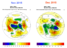
@ Grit speaking of November as a probable compass for how December and perhaps rest of winter turn out.

Judah Cohen was alluding to the same thing today in his newsletter

"If my forecast of the stretched PV verifies, it seems highly likely that a western ridge/eastern trough pattern will once again establish itself in early November, and possibly even the very end of October. One stretched PV is unlikely to be enough to force the November monthly means, but two would probably do it. This is of course all highly speculative on my part but if we do somehow get two stretched PVs in November that sets up a very interesting juxtaposition of what November is suggesting for the winter and the inevitability of the super El Niño imprint on the upcoming North American winter. At least here in Boston the TV mets love to say as goes November so goes the winter. That will setup a very intriguing conundrum for these same TV mets – tow the party line and go with a mild winter guaranteed by the super El Niño or go with this popular rule of thumb? Maybe more wishcasting on my part but if by some chance it materializes, grab the popcorn! I have a lot more I would like to share on the El Niño forecasts and their sense of inevitability, but I am running out of time, so it will have to wait for another day."
 
@ Grit speaking of November as a probable compass for how December and perhaps rest of winter turn out.

Judah Cohen was alluding to the same thing today in his newsletter

"If my forecast of the stretched PV verifies, it seems highly likely that a western ridge/eastern trough pattern will once again establish itself in early November, and possibly even the very end of October. One stretched PV is unlikely to be enough to force the November monthly means, but two would probably do it. This is of course all highly speculative on my part but if we do somehow get two stretched PVs in November that sets up a very interesting juxtaposition of what November is suggesting for the winter and the inevitability of the super El Niño imprint on the upcoming North American winter. At least here in Boston the TV mets love to say as goes November so goes the winter. That will setup a very intriguing conundrum for these same TV mets – tow the party line and go with a mild winter guaranteed by the super El Niño or go with this popular rule of thumb? Maybe more wishcasting on my part but if by some chance it materializes, grab the popcorn! I have a lot more I would like to share on the El Niño forecasts and their sense of inevitability, but I am running out of time, so it will have to wait for another day."
Yeah I read that after you posted about it. Only thing is, I'm on the train that it's unlikely that both Dec and Jan will be cold....and I'd rather sacrifice Dec for better climo and chances popping up mid-late winter, but we'll see how it goes in the end. It was striking though how those super ninos kept their pattern from Nov-Dec like that
 
I personally would rather have nov and dec warm and hope jan and feb turn colder. What strong niños had a -pdo and +qbo? Maybe you guys mentioned it but can't remember lol
 
I personally would rather have nov and dec warm and hope jan and feb turn colder. What strong niños had a -pdo and +qbo? Maybe you guys mentioned it but can't remember lol

Looking at only very strong Ninos:

QBO table goes back only to the 1957-8 very strong Nino:

+QBO dominating DJF like it almost definitely will in 2026-7: 2015-6, 1982-3, 1957-8
-PDO DJF average <0:
- only 1972-3 and that averaged only barely -PDO (-0.1)…I classify that as neutral;
-1965-6 averaged barely +, which I also count as neutral
 
Last edited:
Back
Top